Important Takeaways:
- In recent days, forecasters tracked no fewer than six cyclones that formed across the Indian Ocean and South Pacific, some of which have the potential to impact landmasses.
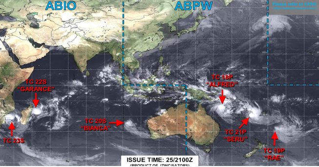
- Satellite imagery from the Joint Typhoon Warning Center showed cyclones stretching from off the coast of Africa and Madagascar to both coasts of Australia, with the names Alfred, Seru, Rae, Honde, Garance and Bianca.
- Among these storm systems, Cyclones Honde and Garance appeared to have the potential for the most immediate disruptions, particularly in regions such as Madagascar and Mozambique, where heavy rainfall and gusty winds were expected.
- The primary focus of meteorologists in the Land Down Under was Cyclone Alfred, which was forecast to make a direct hit on the Australian coastline in the coming weeks… raising concerns about potential flooding and significant travel disruptions.
- According to data compiled by Colorado State University, tropical cyclone energy in the Southern Hemisphere is running more than 138% above normal.
- Despite the current wave of cyclone activity, forecasters expect it to be the final major bout of the season, as the season will quickly come to an end over the next few weeks.
- Water temperatures will begin to cool as the Sun shifts to the Northern Hemisphere after the spring equinox, marking the transition towards the start of cyclone seasons across the Northern Hemisphere.
Read the original article by clicking here.


