Sri Lanka’s torrential rains drive more than 130,000 from homes

People walk through a flooded road after they moved out from their houses in Biyagama

COLOMBO (Reuters) – Flash floods and landslides in Sri Lanka, triggered by more than three days of heavy rain, have forced more than 130,000 people from their homes and killed at least 11, disaster officials said on Tuesday.

Troops have launched rescue operations in inundated areas of the Indian Ocean island, with boats and helicopters pulling more than 200 people trapped in the northwestern coastal district of Puttalam to safety, officials said.

“This is the worst torrential rain we have seen since 2010,” said Pradeep Kodippili, a spokesman for the disaster management center. Nineteen of Sri Lanka’s 25 districts have been hit.

Heavy rains have also struck the neighboring Indian states of Tamil Nadu and Kerala. More than 100 houses were damaged in coastal Kerala and about 50 families had been shifted to a relief camp in the state capital, Thiruvananthapuram, a state official said.

The weather department has forecast heavy rains across Tamil Nadu over the next two days and warned fishermen not to go out to sea.

Flooded roads and fallen trees led to traffic jams in the Sri Lankan capital, Colombo. Trains were halted as water submerged railway tracks, officials said.

Flooding and drought are cyclical in Sri Lanka, which is battered by a southern monsoon between May and September, while a northeastern monsoon runs from December to February.

(Reporting by Ranga Sirilal; Writing by Shihar Aneez; Editing by Nick Macfie)

9 dead, in Houston Flood; more rain coming

Flood waters cover the area of FM 1463 at IH-10 in Fort Bend County

HOUSTON (Reuters) – At least nine people have died and some 1,150 homes have been damaged in flooding triggered by torrential downpours in the Houston area this week, officials said on Wednesday, as forecasts called for more rain.

Eight of those killed were found in vehicles that had been in flooded areas, the Harris County Institute of Forensic Sciences and a local sheriff said, adding that medical examiners were working to confirm the causes of death.

The National Weather Service said more rain is on tap for the city, the country’s fourth largest, after a record-setting drenching that dumped as much as 18 inches (45 cm) on some parts of the Houston area on Monday.

The weather service has issued a flood watch from central Texas through Houston and into large parts of Louisiana.

There have been more than 1,200 water rescues during the recent flooding, with emergency crews shuttling people by boat to dry ground and picking up motorists whose cars were caught in rushing waters.

The Houston Independent School District, the country’s seventh-largest school district, said it would reopen on Wednesday after the flooding caused hundreds of schools to close earlier this week.

Heavy storms can overwhelm the drainage channels that move water from Houston back to the Gulf of Mexico, particularly if the ground is already saturated.

The city faced similar widespread flooding during a storm last May and Tropical Storm Allison’s torrent in 2001.

(Reporting by Jon Herskovitz in Austin, the Houston bureau and Brendan O’Brien in Milwaukee; Writing by Jon Herskovitz; Editing by Marguerita Choy and Paul Simao)

Storms Shut Down Most of Houston

The city of Houston, Texas was largely shut down on Monday after a stalled storm system caused severe flash flooding that has schools closed, bus and rail services suspended, and government officials warning residents to stay home.

According to The Weather Channel, rainfall totals were 10-20 inches from southeast Texas to the northwest of Houston. Some places saw 3 to 4 inches of rain per hour. Authorities reported that there were at least 650 residential calls for help on Monday morning.

Harris County Judge Ed Emmett told CNN that there were at least 150 water rescues in Harris County alone, and he suspects there will be more rescues as the flooding gets worse.

CNN also reported as of mid-morning that at least 100,000 homes and businesses were without power in the Houston area, and over 1,000 homes in Harris County were flooded.

Houston Mayor Sylvester Turner told reporters that the Houston area schools were closed along with nine regional hospitals that were closed to additional patients. He added that three apartment buildings had been evacuated, and the residents were taking shelter in a mall. At this time, multiple news outlets have stated that there are no reports of injuries or deaths.

The storm system causing the severe flooding will continue pelting the south through Tuesday before the system moves northwest and weakens. The storm could still produce severe thunderstorms capable of producing hail, strong winds, and even isolated tornadoes, according to CBS News.

Other residents in Mississippi and Louisiana also saw flash flooding according to WISHTV. The Salvation Army, the United Way of Southeast Louisiana, Convoy of Hope, Mercy Chefs, and the Second Harvest Food Bank are all taking donations for the victims of the flooding in Louisiana and Mississippi.

Oklahoma has also seen flooding according Oklahoma City station, KOCO. Approximately 7,000 acres of farmland is under water, and the Washita River is expected to crest Monday evening, bringing even more flooding.

Duo Storms Bring Potential Flooding and Snow to High Plains and Rockies

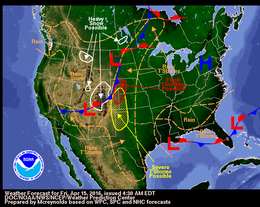
Duo storm systems over the Midwest and Rockies is likely to produce heavy rainfall capable of flooding, severe thunderstorms, and even snow.

The Weather Channel reports that the High Plains will see severe thunderstorms and even some flooding as the 4-5 day period of rain falls over the area. Some parts of the plains may even set all-time monthly records for April.

Many areas in the Plains from South Dakota to Texas could see at least 3 inches of rainfall through Tuesday evening. Parts of Kansas, Oklahoma, Nebraska, and Texas could see around 5-8 inches of rain over the next few days.

Additionally, this storm could produce severe thunderstorms with large hail, damaging winds, and possibly tornadoes.

And if that weren’t enough, the High Plains may also see snow as Winter Storm Vexo hits the Rockies this weekend.

The National Weather Service has issued winter storm warnings for parts of Utah, Colorado, and Wyoming. So far, The Weather Channel has reported that Nebraska and South Dakota will be the only states in the High Plains to possibly see snow.

Winter Storm Vexo will also bring strong winds that could reach gusting speeds of 30-50 mph and may cause power outages throughout the Rockies and High Plains.

Weekend Weather Promises Big Mix

This weekend weather promises a big mix of severe storms, snow, flooding and tornadoes. With a storm system moving across the Central and Southern Plains, a cold front on the East Coast and freezing weather setting in across numerous locations, you don’t have to go far for something different in your weather conditions.

According to the National Weather Service, The western U.S. will remain mostly dry through the weekend as high pressure remains in places across the region. Severe thunderstorms in the central and southern plains will produce hail, damaging winds and some tornadoes. This system will also produce flash flooding and snow over portions of the upper great lakes and central rockies.

The Weather Channel reports that multiple rounds of strong to locally severe storms are possible from Delaware and southeastern Virginia to the Carolinas, south/central Georgia, northern Florida, southern Alabama, southern Mississippi, and southeast Louisiana, as a cold front slowly pushes southeast.

A few thunderstorms may also develop farther north into Pennsylvania, New Jersey, New York and New England. The potential impacts of these storms could be damaging wind gusts and large hail, though a few tornadoes are possible.
Flash flooding will remain a threat from the Carolinas and Georgia, southern Alabama, the Florida panhandle, coastal Mississippi and southeast Louisiana.

The National Weather Service also reported that heavy rain and strong storms were expected for the Southeast states and snow with much colder temperatures will be the norm from the upper midwest to the Northeast this weekend.

Several tornadoes were reported in Mississippi and Alabama Thursday evening as a multi-day round of severe weather clobbered the South, and the threat persisted Friday morning into Georgia in reports by The Weather Channel.

One twister touched down in Lowndes County, Mississippi, near New Hope before rising off the ground and touching down again across the state line in Alabama near Ethelsville. Lowndes County Emergency Management Service Director Cindy Lawrence told the Associated Press that at least a dozen homes near New Hope were damaged by the storm, but there were no injuries. Survey crews from the National Weather Service found two EF1 tornadoes hit northern Pickens County in Alabama.

A Mississippi teen was killed earlier in the day Thursday in a wreck on wet roads.

For those of you experiencing any severe weather in your area, please stay tuned to your local weather stations for up to date information.

Southern U.S. flooding causes closure of major highway

SAN ANTONIO (Reuters) – Flooding caused by days of heavy rain forced the closure on Tuesday of a section of a major east-west U.S. highway on the Louisiana-Texas border along the rising Sabine River, officials in both states said.

At least five people have been killed in storms in Southern U.S. states over the past several days that have caused flooding in places including Texas, Louisiana, Mississippi and Arkansas, forcing thousands of people to flee homes caught in floodwaters.

The closure of the section of Interstate 10 was forcing drivers to take lengthy detours of up to hundreds of miles to traverse the flood-soaked region.

Flooding along the Sabine River that separates Texas and Louisiana has forced the evacuation of hundreds of people from their homes. Texas Governor Greg Abbott late on Monday issued a disaster declaration for 17 eastern and southeastern Texas counties.

In Louisiana, state officials said more than 6,000 structures had been damaged by flooding across the state, and new problems were being reported in some areas as rivers continued to rise.

Since last Wednesday, the Louisiana National Guard has rescued more than 4,200 people while the state’s Department of Wildlife and Fisheries has rescued another 700 people.

The hardest-hit parts of Texas have been in the southeastern part of the state, where “dozens if not hundreds” of high water rescues have taken place, according to Emergency Management Coordinator Billy Smith.

“It will probably be several days before it crests,” Smith said of the floodwaters, adding that the Sabine River is expected to crest at a level higher that the previous record set in 1882.

In eastern Harrison County in Texas, sheriff’s office Lieutenant Jay Webb said the high waters have raised worries about alligators.

“The nature of alligators is they don’t want to stay in water,” Webb said. “They want to be on higher ground with access to water. With flood levels porch-high, those alligators may be on somebody’s back porch.”

Authorities described the flooding as some of the worst in the region apart from that spawned by hurricanes. President Barack Obama on Sunday declared the flooding in Louisiana a major disaster, activating federal aid.

(Reporting by Jim Forsyth; Additional reporting by Colleen Jenkins in North Carolina; Writing by Jon Herskovitz; Editing by Will Dunham)

Five dead in storms in U.S. South as floods continue

SHREVEPORT, La. (Reuters) – The death toll from storms in Southern U.S. states rose to five as storm-weary residents of Louisiana and Mississippi watched for more flooding on Monday from drenching rains that inundated homes, washed out roads and prompted thousands of rescues.

Flood waters across Louisiana were blamed for four deaths and damage to at least 5,000 homes, and one person drowned in a flooded area in Oklahoma last week. Flood warnings were in effect as rivers, bayous and creeks stayed high after storms dumped more than 20 inches of rain in some places.

In Louisiana, Harold Worsham, 78, drowned in Saline Bayou when his boat capsized as he tried to remove items from a home as waters rose on Saturday night, according to the Natchitoches Parish Sheriff’s Office.

Many rivers and lakes in northern Louisiana have risen to historic levels and homes there face the threat of yet more flooding, said Matt Hemingway, a National Weather Service meteorologist in Shreveport.

“It’s going to take some time for them to fall back down below flood stage,” he said. “Some folks may be in this situation not just days but weeks.”

Authorities and meteorologists described the flooding as some of the worst seen in the region apart from that spawned by hurricanes. President Barack Obama declared flooding in Louisiana a major disaster on Sunday, activating federal aid.

The Louisiana National Guard said it had rescued more than 3,000 people and 300 pets.

Weldon Thomas, who lives in the Lake Bistineau area, said the flood was devastating for many of his neighbors.

“This is the worst flood that these people have ever seen, and some of them have been there 60 or 70 years,” he said. “It’s a tragic situation for everybody.”

In Bossier Parish, several feet of water covered low parts of normally busy Highway 71 and water rose to the top of road signs. Stranded livestock huddled on patches of dry land.

Emergency officials in Mississippi said flooding threatened to close interstates 59 and 10, which they warned could result in major traffic congestion.

As of Sunday afternoon, 185 homes were destroyed or significantly damaged in Mississippi and about 650 more sustained minor damage, according to the state.

Mandatory evacuation orders issued by authorities in the Texas county of Newton, which borders Louisiana, remained in effect for people living near the Sabine River over flood dangers.

(Additional reporting and writing by Colleen Jenkins and Curtis Skinner; Editing by Dan Grebler and James Dalgleish)

Flooding continues across South, more rain on the way

Heavy rains continued to pummel the South on Thursday morning, spurring concerns about more flash flooding in states that have already received more than nine inches of rain this week.

The National Weather Service had issued new flash flood warnings for portions of Texas, Arkansas, Mississippi and Louisiana, the four states hit the hardest by this week’s storms.

It also issued numerous other flood warnings and flash flood watches in the Mississippi and Ohio valleys as the storms threatened to bring multiple inches of rain today and tomorrow.

National Weather Service storm reports indicate that Northern Louisiana has seen the heaviest rains since Monday, with more than 17 inches falling at Monroe Regional Airport as of 9 a.m. Thursday. More than 14 inches fell in Bossier City, and Shreveport received more than 10.

Louisiana Governor John Bel Edwards declared a state of emergency in 16 parishes affected by the severe weather. One of them was Bossier Parish, where the local sheriff’s office reported that a mandatory evacuation was ordered for at least 1,000 homes as the Red Chute Bayou rose.

The National Weather Service’s office in Shreveport said that evacuations also occurred in Haughton and Minden, and the floods led to “numerous” road closures and high-water rescues.

Texas, Mississippi and Arkansas also had at least one community where nine or more inches fell, and those states were all experiencing some degree of flooding on Thursday.

The National Weather Service website showed dozens of river gauges in those states were at flood stage, adding that “major flooding” in at least six locations in Texas and Louisiana. Dozens more were near flood stage, and the additional rainfall threatened to push water levels higher.

The heaviest rains are expected along the southern banks of the Mississippi River, and the service said parts of Mississippi and Louisiana could receive five or more additional inches.

Heavy rains spur flash flooding in South, more rain on the way

Portions of three states were under flash flood warnings on Wednesday afternoon as a slow-moving storm brought more heavy rain and damage to the already-waterlogged South.

The National Weather Service issued the warnings for select counties in Arkansas, Louisiana and Texas, indicating that flash flooding was already occurring in those regions.

The service also issued flash flood watches for other counties in those three states and portions of six others — Illinois, Missouri, Kentucky, Tennessee, Oklahoma and Mississippi — cautioning that the inches of additional rain in the forecast could spur rapidly rising waters later this week.

The National Weather Service said Louisiana, Texas and Arkansas are still expected to see the worst of the storms, and could receive more than eight inches of additional rain by week’s end.

The service said each of those three states had at least one community where more than five inches of rain fell between Monday and Wednesday morning. That included more than one foot near Minden, Louisiana, which is located about 35 miles east of Bossier City in Webster Parish.

The Webster Parish Sheriff’s Office shared numerous photographs of flooding on its Facebook page, including a stretch of Interstate 20 that had been completely submerged. Another photo showed a stretch of Methodist Camp Road, which runs through Minden, had been washed out.

In Bossier Parish, authorities were calling for a voluntary evacuation in some flood-prone areas as waters of the Red Chute Bayou and Flat River continued to rise, according to a news release.

The severe weather prompted government offices in Webster, Bossier and four other Northern Louisiana parishes to close early on Wednesday, the state’s commissioner of administration said in a news release. Grambling State University and Louisiana Tech also cancelled classes.

The other areas in the flash flood watches were expected to see less rainfall, but multiple inches were possible. Residents of all of the affected states should monitor their local forecasts.

Tornado reported, flash flood watches expanded as severe weather targets South

Portions of the Southern Plains on Tuesday morning were beginning to feel the force of the thunderstorms and flash flooding that is expected to hit the region over the next few days.

National Weather Service radar showed rain falling across Texas and Oklahoma, the beginning of a series of thunderstorms forecast to bring up to 10 inches of rain to the South by Thursday.

The service said the thunderstorms could also generate tornadoes, and its Storm Prediction Center had already received one report of a funnel cloud in Texas by 10 a.m. Central Time.

A tornado watch was in effect for 31 counties in Texas. It was set to expire at 1 p.m. today.

Other counties in the Dallas-Fort Worth area were under warnings and watches for severe thunderstorms, and the service advised high wind gusts and penny-sized hail were possible.

The National Weather Service also expanded its flash flood watches to larger parts of Texas, Oklahoma, Arkansas and Louisiana, warning waters could rise quickly in those areas. The highest rainfall totals are still expected in East Texas, Western Louisiana and Southwest Arkansas, but updated forecasts show parts of Missouri and Oklahoma could receive 4 inches.

Many of the flash flood watches are slated to begin this afternoon and continue through Thursday, though residents of the affected areas should monitor their local forecasts.

The service’s Storm Prediction Center said communities in South Texas, as well as those along the state’s Gulf Coast, had the highest risk of experiencing severe thunderstorms today. It said there was an “enhanced” risk of the storms in those areas, the middle level on a five-tier system.

But the tornado was reported in Tolar, which is located about 80 miles southwest of Dallas.

The Storm Prediction Center had received at least 10 reports of high winds as of 10 a.m. Central Time, all in North Texas. The reports indicated that gusts of up to 70 mph were recorded in Tarrant County, where a roof was blown off a business and large branches fell on a sidewalk.

Utility company Oncor said about 36,000 of its customers in the Dallas-Fort Worth area were without power as of 10 a.m. Tuesday. And flight monitoring website flightaware.com said some 230 flights to or from Dallas-Fort Worth International Airport had been delayed by that time.