Rumbling volcano shuts down Philippine capital

By Karen Lema and Enrico Dela Cruz

MANILA (Reuters) – Schools and businesses shut across the Philippine capital on Monday as a volcano belched clouds of ash across the city and seismologists warned an eruption could happen at any time, potentially triggering a tsunami.

Thousands of people were forced to evacuate their homes around Taal, one of the world’s smallest active volcanoes, which spewed ash for a second day from its crater in the middle of a lake about 70 km (45 miles) south of central Manila.

Residents living near the errupting Taal Volcano evacuate in Lemery, Batangas City, Philippines, January 13, 2020. REUTERS/Eloisa Lopez

“The speed of escalation of Taal’s volcanic activity caught us by surprise,” Maria Antonia Bornas, chief science research specialist at the Philippine Institute of Volcanology and Seismology, told reporters.

“We have detected magma. It’s still deep, it hasn’t reached the surface. We still can expect a hazardous eruption any time.”

Authorities warned that an eruption could send a tsunami surging across the lake.

More than 24,000 people have been evacuated from the volcanic island and the area immediately around it – normally a popular tourist spot.

“We got scared of what could happen to us, we thought the volcano was going to erupt already,” said Marilou Baldonado, 53, who left the town of Laurel with only two sets of clothes after she saw the huge ash cloud build.

Some tourists ignored the dangers and traveled to towns close to the volcano to get a better look.

Residents living near the errupting Taal Volcano evacuate in Agoncillo, Batangas City, Philippines, January 13, 2020. REUTERS/Eloisa Lopez

“It’s a once in a lifetime experience for us,” Israeli tourist Benny Borenstein told Reuters as he snapped photos of Taal from a vantage point in Tagaytay City, about 32 km away.

To the southwest of the volcano, the towns of Agoncillo and Lemery were coated by a thick layer of ash, making roads impassable.

Agoncillo’s mayor, Daniel Reyes, told DZMM radio some homes and part of a building had collapsed under the weight of the fallen ash.

In nearby Talisay Batangas, Vice Governor Mark Leviste said rain had turned ash to mud and trucks were needed to evacuate more people from remote communities.

“There is no power. Even water was cut, so we are in need of potable water,” he said. “We are in need of face masks.”

SHUT DOWN

In Manila, masks sold out quickly after residents were advised to wear them if they had to go out. Some wore handkerchiefs across their faces as they breathed air tainted by the smell of sulfur.

Streets that would normally be snarled with some of the world’s worst traffic were largely empty in the city of 13 million people.

Schools and government offices were closed on official orders. The stock exchange suspended trading and many private businesses shut for the day too.

Classes in some cities in the capital will remain suspended on Tuesday, officials said.

Lightning strike in the midst of Taal volcano explosion is seen in Lipa City, Philippines January 12, 2020 in this picture obtained from social media. Cheslie Andal/via REUTERS

Flight operations at Manila’s international airport partially resumed, authorities said, after more than 500 flights were delayed or canceled on Sunday.

One flight that did land carried President Rodrigo Duterte, who was coming back from his home city of Davao in the southern Philippines. He had been unable to fly on Sunday because visibility was so low.

One of the most active volcanoes in the Philippines, Taal has erupted more than 30 times in the past five centuries, most recently in 1977. An eruption in 1911 killed 1,500 people and one in 1754 lasted for a few months.

The island has been showing signs of restiveness since early last year.

The Philippines lies on the “Ring of Fire,” a belt of volcanoes circling the Pacific Ocean that is also prone to earthquakes.

(Additional reporting by Peter Blaza; Writing by Matthew Tostevin; Editing by Stephen Coates and Andrew Heavens)

‘No signs of life’ on New Zealand volcano island after disaster ‘waiting to happen’

By Charlotte Greenfield

WHAKATANE, New Zealand (Reuters) – New Zealand said on Tuesday that eight people were missing, presumed dead, a day after a volcano unexpectedly erupted off the coast of New Zealand’s North Island, killing at least five people and injuring more than 30.

Prime Minister Jacinda Ardern told reporters in Whakatane, a town near the volcanic White Island tourist attraction, that aerial reconnaissance flights had shown no signs of life.

“It’s now clear that there were two groups on the island – those who were able to be evacuated and those who were close to the eruption,” Ardern told reporters.

New Zealanders and tourists from Australia, the United States, Britain, China and Malaysia were among the missing and injured, she said, adding that there were two explosions in quick succession. No further details were given.

“To those who have lost or are missing family and friends, we share in your unfathomable grief in this moment at time and in your sorrow,” Ardern said.

Waikato Police Superintendent Bruce Bird said 47 people visited the island on Monday – five were confirmed to have been killed and eight were missing. Some 31 were in hospital and three had been discharged.

Police said they did not expect to find any more survivors from the eruption, which spewed a plume of ash thousands of feet into the air. Many of the injured were in critical condition, most from burns, Ardern said.

White Island is about 50 km (30 miles) from the east coast of North Island and huge plumes were visible from the mainland. Volcanologists said the ash plume shot 12,000 feet (3,658 m) into the air.

“White Island has been a disaster waiting to happen for many years,” said Ray Cas, a professor emeritus at Monash University, in comments published by the Australian Science Media Centre.

“Having visited it twice, I have always felt that it was too dangerous to allow the daily tour groups that visit the uninhabited island volcano by boat and helicopter.”

Bird said rescue services were working to return to the island and were relying on advice from scientific and technical experts meeting in Wellington on Monday.

“We will only go to the island if it is safe for our people,” said Bird.

Many day tours visit the island regularly. One from a 16-deck cruise liner, Ovation of the Seas, was there at the time.

Ardern said helicopters made a deliberate decision to fly to the island to rescue survivors immediately after the eruption. Graphic: Volcanic Eruption in New Zealand, https://tmsnrt.rs/38iBpyN

“I want to acknowledge the courageous decision made by first responders and those pilots who in the immediate rescue effort made an incredibly brave decision under extraordinarily dangerous circumstances in an attempt to get people out,” she Ardern.

“As a result of their efforts a number of people were rescued from the island.”

‘THIS IS NOT A JOKE’

Janet Urey, 61, a nurse from Richmond, Virginia, said her son Matthew, 36, was injured in the eruption while on honeymoon.

“The phone rang at midnight. Then I heard a voicemail come on. It was my son. He said, Mom…this is not a joke. A volcano erupted while we were on the island. We’re at the hospital with severe burns.”

She has been frustrated by the lack of information from the cruise ship he was on and from authorities.

“I have not heard a word from the cruise people. I just want the word out there. I’m not really happy with how this has been handled,” she added.

A crater rim camera owned and operated by New Zealand science agency GeoNet showed groups of people walking toward and away from the rim inside the crater, from which white vapor constantly billows, in the hour leading up to the eruption.

Michael Schade, an engineering manager from San Francisco, was one of the tourists who made it off the island just before the eruption.

“This is so hard to believe,” Schade said in a video posted on Twitter as he sped away from the island by boat. “Our whole tour group were literally standing at the edge of the main crater not 30 minutes before.”

Geological hazard tracker GeoNet raised the alert level for the White Island volcano in November due to an increase in volcanic activity.

The volcano’s last fatal eruption was in 1914, when it killed 12 sulfur miners. There was a short-lived eruption in April 2016. Daily tours allow more than 10,000 people to visit the volcano every year.

‘Whakaari’, as it is known in the Maori language, is New Zealand’s most active cone volcano, built up by continuous volcanic activity over the past 150,000 years, GeoNet said.

About 70 percent is under the sea, making the massive volcanic structure the largest in New Zealand.

(Additionial reporting by Barbara Goldberg; Writing by Praveen Menon; Editing by Mark Heinrich and Nick Macfie)

‘Leave now’: Australians urged to evacuate as ‘catastrophic’ fires loom

‘Leave now’: Australians urged to evacuate as ‘catastrophic’ fires loom
By Colin Packham

SYDNEY (Reuters) – Authorities declared a state of emergency across a broad swath of Australia’s east coast on Monday, urging residents in high risk areas to evacuate ahead of looming “catastrophic” fire conditions.

Bushfires burning across New South Wales (NSW) and Queensland states have already killed three people and destroyed more than 150 homes. Officials expect adverse heat and wind conditions to peak at unprecedented levels on Tuesday.

Bushfires are a common and deadly threat in Australia’s hot, dry summers but the current severe outbreak, well before the summer peak, has caught many by surprise.

“Everybody has to be on alert no matter where you are and everybody has to be assume the worst and we cannot allow complacency to creep in,” NSW Premier Gladys Berejiklian told reporters in Sydney.

The country’s most populous city has been designated at “catastrophic fire danger” for Tuesday, when temperatures as high as 37 degrees Celsius (98.6 degrees Fahrenheit) are forecast to combine with powerful winds for potentially deadly conditions. It is the first time Sydney has been rated at that level since new fire danger ratings were introduced in 2009.

Home to more than 5 million people, Sydney is ringed by large areas of bushland, much of which remains tinder dry following little rain across the country’s east coast in recent months.

“Tomorrow is about protecting life, protecting property and ensuring everybody is safe as possible,” Berejiklian said.

Lawmakers said the statewide state of emergency – giving firefighters broad powers to control government resources, force evacuations, close roads and shut down utilities – would remain in place for seven days.

On Monday afternoon, the fire service authorised use of the Standard Emergency Warning Signal, an alarm and verbal warning that will be played on radio and television stations every hour.

NSW Rural Fire Service (RFS) Commissioner Shane Fitzsimmons urged people to evacuate before conditions worsened, warning that new fires can begin up to 20km (12 miles) ahead of established fires.

“Relocate while things are calm without the pressure or anxiety of fires bearing down the back door,” he said.

Authorities stressed that even fireproofed homes will not be able to withstand catastrophic conditions, which Fitzsimmons described as “when lives are lost, it’s where people die”.

More than 100 schools will be closed on Tuesday.

On Monday afternoon, rescue services were moving large animals from high risk areas, while health officials warned that air quality across NSW will worsen as winds blow smoke from the current mid-north coast bushfires south.

The fires have already had a devastating impact on Australia’s wildlife, with about 350 koalas feared dead in a major habitat.

CLIMATE CHANGE DEBATE

Australia’s worst bushfires on record destroyed thousands of homes in Victoria in February 2009, killing 173 people and injuring 414 on a day the media dubbed “Black Saturday”.

The current fires, however, come weeks ahead of the southern hemisphere summer, sharpening attention on the policies of Australia’s conservative government to address climate change.

Environmental activists and opposition lawmakers have used the fires to call on Prime Minister Scott Morrison, a supporter of the coal industry, to strengthen the country’s emissions targets.

Morrison declined to answer questions about whether the fires were linked to climate change when he visited fire-hit areas in the north of NSW over the weekend.

Deputy Prime Minister Michael McCormack on Monday accused climate activists of politicising a tragedy at the expense of people in the danger zones.

“What we are doing is taking real and meaningful action to reduce global emissions without shutting down all our industries,” McCormack told Australian Broadcasting Corp radio.

“They don’t need the ravings of some pure, enlightened and woke capital city greenies at this time, when they’re trying to save their homes.”

(Reporting by Colin Packham. Editing by Lincoln Feast and Jane Wardell)

New Fast-moving Los Angeles wildfire destroys homes, prompts evacuation orders

Fast-moving Los Angeles wildfire destroys homes, prompts evacuation orders
(Reuters) – Thousands of people in Los Angeles were ordered to evacuate after a fast-moving brush fire ignited early on Monday morning near the Getty Center museum, the latest outbreak in a wildfire season that has scorched parts of California.

Spot fires break out on a hillside as the Getty Fire burns in west Los Angeles, California, U.S. October 28, 2019. REUTERS/Gene Blevins

Spot fires break out on a hillside as the Getty Fire burns in west Los Angeles, California, U.S. October 28, 2019. REUTERS/Gene Blevins

The fire broke out around 1:30 a.m. (0830 GMT) and has since grown to consume more than 500 acres (202 hectares) in the scrub-covered hills around Interstate 405, near some of the city’s most expensive homes. Commuters posted videos of slopes aglow with orange flames close to the road’s edge.

At least five homes had burned down but there were no reported injuries, Mayor Eric Garcetti told reporters at a news conference with fire officials, warning that he expected the number to rise.

“This is a fire that quickly spread,” he said, urging residents in the evacuation zone, which encompasses more than 3,300 homes, to get out quickly.

Los Angeles Lakers star LeBron James, who lives in the area, said he had heeded the warning and had been driving around before dawn with his family looking for shelter.

“Finally found a place to accommodate us!” he wrote a short time later on Twitter. “Crazy night man!”

Officials at the Getty art museum said the fire was burning to the north of the building, which was designed with thick stone walls to prevent fire from damaging its treasures.

The fierce winds fanning wildfires elsewhere in the state, including a large fire consuming parts of the picturesque wine country north of San Francisco, were expected to abate on Monday.

But forecasters with the National Weather Service said high winds would return later in the week and could be the strongest so far this year in the south of the state.

Marc Chenard, a forecaster with the NWS’s Weather Prediction Center, said wind gusts in northern California would abate by midday and in the south of the state by later in the afternoon.

Wind gusts can be between 50 to 60 miles per hour (80-96 kph), with some significantly higher, he said.

The northern California wine country has borne the brunt of the fires, with 84 square miles (218 sq km) burned and 190,000 people evacuated in the Kincade fire.

Only about 5% of that fire was contained early on Monday after crews lost ground against the wind-driven wildfire a day earlier.

About 3,000 people were battling the Kincade Fire, the worst of more than a dozen major blazes that have damaged or destroyed nearly 400 structures and prompted Governor Gavin Newsom to declare a statewide emergency.

Investigators have not yet said what they believed caused the blaze, although it ignited near a broken wire on a Pacific Gas & Electric <PCG.N> transmission tower.

POWER OUTAGES

More than a million homes and businesses were without power on Monday morning, most of those from planned outages. Forecasts of high winds had prompted PG&E to shut off power to 940,000 customers in 43 counties on Saturday night to guard against the risk of touching off wildfires.

PG&E expects to issue a weather all clear for safety inspections and restoration work to begin early Monday morning for the northern Sierras and North Coast, the company said.

The governor has been sharply critical of PG&E, saying corporate greed and mismanagement kept it from upgrading its infrastructure while wildfire hazards have steadily worsened over the past decade.

PG&E filed for bankruptcy in January, citing billions of dollars in civil liabilities from deadly wildfires sparked by its equipment in 2017 and 2018.

(Reporting by Stephen Lam in Healdsburg, California, additional reporting by Jonathan Allen in New York and Rich McKay in Atlanta; Editing by Scott Malone, Steve Orlofsky and Bill Berkrot)

Floodwaters rise on Charleston’s streets as Hurricane Dorian skirts U.S. coast

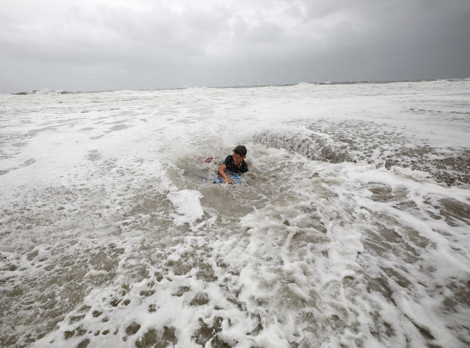
Nathan Piper, 11, is swamped by increasingly rough waves while body surfing as Hurricane Dorian approaches, in Carolina Beach, North Carolina, U.S., September 5, 2019. REUTERS/Jonathan Drake

By Nick Carey and Amanda Becker

CHARLESTON, S.C. (Reuters) – Deserted, rain-lashed streets in Charleston, South Carolina, vanished beneath water on Thursday as Hurricane Dorian churned a few dozen miles offshore after reducing parts of the Bahamas to rubble.

Water pooled a few inches deep near the centuries-old waterfront. In certain low-lying blocks, it rose to a foot or more, as high tide approached and forecasters warned of storm surges of up to 8 feet (2 meters).

John Rivers, 74, and his three children were among the few to be seen in the streets on Thursday. They cleared drains of branches, leaves and debris, using a shovel, a rake and their bare hands.

“We’re giving the water somewhere to go,” Rivers said, sheltering temporarily from the driving rain and gusts of wind under a covered walkway. His daughter Caroline, 12, pulled off her rubber boots one at a time, emptying a stream of water from each. “I see this as a good life lesson for my kids,” Rivers said.

Officials said Thursday afternoon that more than 7 inches (18 cm) of rain had fallen in parts of Charleston.

Dorian was about 50 miles (80 kilometers) off Charleston on Thursday, wavering in strength between a Category 2 and 3 on the five-step Saffir-Simpson wind scale. It was forecast to possibly make landfall in North Carolina late Thursday or early Friday.

Life-threatening storm surges and dangerous winds were possible in much of the coast of South Carolina, North Carolina and Virginia, the National Weather Service said.

Dorian whipped up at least three tornados in the region, officials said. One in North Carolina damaged scores of trailers in a campground in Emerald Isle, but no one was injured, North Carolina’s News & Observer reported.

Governors in the region declared states of emergency, closed schools, opened shelters, readied national guard troops and implored residents to take warnings seriously, as fresh images of the devastation wrought by the storm in the Bahamas earlier this week continued to circulate in the media.

At least 70,000 Bahamians needed immediate humanitarian relief after Dorian became the most damaging storm ever to hit the island nation.

In the Carolinas alone, more than 900,000 people had been ordered to evacuate their homes. It was unclear how many did so.

In Kill Devil Hills, in North Carolina’s Outer Banks, Mark Jennings decided to ignore the order, lining his garage door with sandbags and boarding up his home with plywood.

The retired firefighter planned to stay put with his wife and two dogs: “We are ready to go. If something happens, we can still get out of here.”

FOUR DEATHS IN THE U.S.

At least four storm-related deaths have already been reported. Three people died in Orange County, Florida, during storm preparations or evacuation, according to the Orange County mayor’s office. In North Carolina, an 85-year-old man fell off a ladder while barricading his home for Dorian, the governor said.

More than 210,000 homes and businesses were without power in South Carolina and Georgia early on Thursday, according to local electric companies.

On Charleston’s historic South Battery Street, which runs down to the harbor, Brys Stephens tried to keep the water away from his stately home, built in the veranda-wrapped Southern style that lures crowds of tourists to the city.

He and his family pumped water out of the yard and tried to reattach metal flood gates into the perimeter wall.

“The gates worked pretty well so far and we’ve managed to keep water away from the house,” Stephens said. “But we’ve got another storm surge coming later on, so we’ll see then if it holds.”

(Reporting by Nick Carey in Charleston, South Carolina, and Amanda Becker in Kill Devil Hills, North Carolina; Additional reporting by Jonathan Allen, Peter Szekely, Matt Lavietes and Scott DiSavino in New York; Writing by Jonathan Allen; Editing by Scott Malone and Bernadette Baum)

Vermont capitol on lockdown after person with gun enters state building: official

FILE PHOTO: People walk past a sign prohibiting firearms and weapons inside the State Legislature in Montpelier, Vermont, U.S., March 13, 2018. REUTERS/Christinne Muschi

(Reuters) – Vermont state office buildings in Montpelier were on lockdown on Friday after a person with a gun was seen entering the complex, the governor’s office said in a statement.

“Evacuation and shelter-in-place procedures were activated, per state security procedures,” the statement from the office of Governor Phil Scott said.

Police from federal, state and local law enforcement agencies were responding, the statement said.

However, the state Department of Human Resources issued a statement saying, “our understanding is that the situation is well under control and not a danger,” according to WCAX TV in Burlington. It did not provide more details.

(Reporting by Scott Malone in Boston and Peter Szekely in New York; Editing by Chris Reese and Steve Orlofsky)

Floods in India kill 33, displace thousands

Members of a rescue team wade through a water-logged area during heavy rains on the outskirts of Kochi in the southern state of Kerala, India, August 8, 2019. REUTERS/Sivaram V

By Rajendra Jadhav and Derek Francis

MUMBAI/BENGALURU (Reuters) – Floods brought by heavy rains and overflowing rivers across large swathes of western and southern India have killed at least 33 people and forced the evacuation of 180,000 from their homes, officials said on Thursday.

Seasonal monsoon rains from June to September cause deaths and mass displacement across South Asia every year, but they deliver more than 70% of India’s rainfall, crucial for farm output and economic growth.

The tally of dead in the floods was 25 in the western state of Maharashtra by Thursday, officials said, while government data in the neighboring southern state of Karnataka showed eight dead.

Rivers burst their banks in some parts of Maharashtra after authorities released water from dams brimming with as much as 670 mm (26.4 inches) of rain received in a week.

“If we get more rainfall, then we have no option but to release water in rivers,” said administrative official Deepak Mhaisekar, adding that many reservoirs around the state’s industrial city of Pune were full.

A boat full of villagers trying to escape the floods capsized on Thursday, killing at least 9 people, with rescuers searching for three or four still feared missing, he added.

Thousands of trucks were stuck on a national highway linking the financial capital of Mumbai with the southern technology hub of Bengaluru, as waters submerged the road in some places, Mhaisekar said.

In Karnataka, officials said some major reservoirs were nearly full, and warned that nearby villages could be hit by large discharges of water.

“We have sought help from the central government to rescue any people who may get stranded because of the floods,” Chief Minister B.S. Yediyurappa told media.

Temples and electric poles were underwater as the floods flowed unabated, in video images posted by a journalist in a northern district of Karnataka.

Weather officials have forecast heavy rain in the region, including the nearby states of Kerala and Goa, over the next three to five days.

Kerala weather officials called a “red alert” in four districts they saw at risk of receiving more than 200 mm (8 inches) of rain on Thursday.

Schools and colleges in many places have been shut since Monday and are unlikely to open this week, authorities have said.

(Reporting by Rajendra Jadhav in Mumbai and Derek Francis in Bengaluru; Editing by Euan Rocha and Hugh Lawson)

Isolation, evacuations in U.S. central Plains as floods kill three

Flooded Camp Ashland, Army National Guard facility, is seen in this aerial photo taken in Ashland, Nebraska, U.S., March 17, 2019. Picture taken March 17, 2019. Courtesy Herschel Talley/Nebraska National Guard/Handout via REUTERS

(Reuters) – Flooding that killed three people in the central plains of Nebraska and Iowa has cut roads to a nuclear power plant and inundated a large portion of a U.S. Air Force base, forcing it to work with a skeleton staff on Monday, while more of region’s residents possibly faced evacuation.

The floods, which have prompted each state’s governor to declare a state of emergency, are the result of last week’s “bomb cyclone” winter storm, a winter hurricane that blew in from the western Rocky Mountains. Three people died in the flooding and at least one person was missing after hundreds of weekend rescues.

Flooded Camp Ashland, Army National Guard facility, is seen in this aerial photo taken in Ashland, Nebraska, U.S., March 17, 2019. Picture taken March 17, 2019. Courtesy Herschel Talley/Nebraska National Guard/Handout via REUTERS

Flooded Camp Ashland, Army National Guard facility, is seen in this aerial photo taken in Ashland, Nebraska, U.S., March 17, 2019. Picture taken March 17, 2019. Courtesy Herschel Talley/Nebraska National Guard/Handout via REUTERS

The floodwaters forced the operators of the Cooper nuclear plant, near Brownville, Nebraska, to fly in staff and supplies by helicopter, and covered one-third of that state’s Offutt Air Force Base, near Bellevue, home to the U.S. Strategic Command. The nuclear plant continued to operate safely and was at full power, its operator said.

The National Weather Service reported that some of the region’s larger rivers were running at record highs above flood level, causing levy breaks. Some small towns and communities have been cut off by floods while others have seen fresh drinking water become scarce. Floodwaters destroyed many homes and businesses over the weekend.

The NWS reported that temperatures across the hardest-hit areas will reach above 50 degrees Fahrenheit (10 C) through midweek and exceed 60 Fahrenheit by Friday. That would speed the pace of snow melt across the region and contribute water to already swollen rivers, the NWS said, possibly forcing evacuations in communities along the Missouri River on the Nebraska and Iowa border, as well as along the Elkhorn and Platte rivers in Nebraska.

“There could be issues across portions of Nebraska and Kansas for the next seven days,” NWS meteorologist Jim Hayes said.

Nebraska Governor Pete Ricketts, who declared a statewide emergency last week, said on Monday that emergency officials have rescued about 300 people but that at least one person was missing.

At Offutt Air Force Base, 30 buildings had been flooded by up to 8 feet (2.4 m) of water and 30 more structures had been damaged, according to reports by the Omaha World-Herald, citing a base spokeswoman. Base officials did not immediately respond to a request for comment.

The flooding covered 3,000 feet of the base’s 11,700-foot runway, the World-Herald reported.

The weather was blamed for three deaths, including one person who died at home after failing to evacuate, and a man swept away while trying to tow a trapped car with his tractor.

In Iowa, one man died after he was submerged in floodwaters on Friday in Riverton, according to the Fremont County Sheriff’s Office.

Iowa Governor Kim Reynolds also issued an emergency proclamation at the outset of the flooding.

(Reporting by Gina Cherelus in New York and Rich McKay in Atlanta; Editing by Scott Malone)

Death toll in floods in Indonesia’s Papua rises to nearly 80

Cars are submerged in mud following a flash flood in Sentani, Papua, Indonesia, March 17, 2019 in this photo taken by Antara Foto. Antara Foto/Gusti Tanati/ via REUTERS

JAKARTA (Reuters) – Authorities in Indonesia raised the death toll from floods and landslides in the easternmost province of Papua to nearly 80 on Monday as President Joko Widodo called for the urgent evacuation of victims from devastated communities.

The deadly floods and landslide struck at the weekend after torrential rain fell across the Cyclops mountain range, much of which has been stripped of tree cover by villagers chopping fire wood and farmers cultivating plantations.

The death toll shot up to nearly 80 from 58 on Sunday as rescuers found more victims as they struggled to clear mud, rocks and shattered trees from the area near the provincial capital of Jayapura, including a 70 km stretch of road.

With 43 people missing, Widodo urged rescuers to step up their efforts.

“What is most important is handling the evacuation,” he said in a statement posted on Instagram.

More than 4,000 people have been displaced and are sheltering in tents, schools, and public buildings.

Disaster authorities have warned provincial officials of the danger of flash floods due to deforestation, said Sutopo Purwo Nugroho, spokesman of the national disaster mitigation agency.

The central government sent supplies of seedlings last year, hoping to help restore some forest cover, he said.

(Reporting by Jessica Damiana; Writing by Kanupriya Kapoor)

U.S.-backed Syrian force starts final battle in Islamic State enclave

A fighter of Syrian Democratic Forces (SDF) sits on a vehicle near the village of Baghouz, Deir Al Zor province, Syria February 27, 2019. REUTERS/Rodi Said

By Ellen Francis and Rodi Said

DEIR AL-ZOR PROVINCE, Syria (Reuters) – U.S.-backed Syrian fighters launched an operation on Friday to clear the last remaining pocket of Islamic State fighters from the besieged eastern Syrian village of Baghouz after weeks of delays caused by the evacuation of thousands of civilians.

The Syrian Democratic Forces (SDF) moved on the enclave, a tiny area on the eastern bank of the Euphrates River, at 6 p.m. (1600 GMT) after the last batch of civilians were removed, said Mustafa Bali, the head of the SDF media office.

“Nothing remains in Baghouz except for terrorists. The battle … will not end until the elimination of Daesh and the liberation of the village,” he told Reuters, using an Arabic acronym for Islamic State.

Bali said the initial fighting involved heavy weapons. Asked how long the battle would last, he said: “We expect a fierce and heavy battle.”

The Islamic State enclave at Baghouz, a tiny pocket on the eastern bank of the Euphrates River, is the last populated territory held by the jihadists, who have been steadily driven by an array of enemies from swathes of land they once held.

Though the fall of Baghouz will mark a milestone in the campaign against Islamic State, the group continues to be seen as a security threat, using guerrilla tactics and holding some desolate territory in a remote area west of the Euphrates River.

The SDF commander-in-chief said on Thursday that his force would declare victory over the jihadists in one week.

(Additional reporting by Tom Perry in Beirut and Stephanie Nebehay in Geneva; Writing by Tom Perry/Stephen Kalin in Beirut; Editing by Kevin Liffey)