
Important Takeaways:
- A deadly barrage of severe weather, tornadoes and torrential rain has come to an end, but the danger is far from over in communities across the Midwest and South as angry rivers continue to rise, forcing families from their homes.
- At least 25 people in seven states have been killed due to the severe weather, including deaths from tornadoes and extreme weather in Tennessee, Missouri, Indiana, Arkansas and Mississippi, and fatalities from flooding in Kentucky.
- One of those monster tornadoes was captured live on FOX Weather on Wednesday, April 2, by FOX Weather Exclusive Storm Tracker Brandon Copic.
- That tornado that touched down in northwestern Arkansas prompted forecasters to issue a rare Tornado Emergency as the supercell thunderstorm passed through communities such as Lake City and Blytheville.
- Kentucky Gov. Andy Beshear said at a news conference on Monday. “Remember, this event is not over until the waters have receded. Until the areas that are flooded are fully dry. Until we don’t have saturated ground that could create mudslides over roads and bridges.”
- Beshear said on Monday that more than 500 roads across the state were closed due to historic flooding, mudslides and landslides.
- Tennessee flooding leads to mandatory evacuations
- The order also had a dire warning – those who don’t comply with the evacuation order may not be able to receive help from first responders. In addition, residents may be held personally liable for any damage or injuries sustained.
- Meteorologist-in-Charge at the National Weather Service office in Memphis, Tennessee, Darone Jones, joined FOX Weather on Tuesday morning and said there’s still a lot of recovery ahead for waterlogged communities.
- “It’s very hard to contextualize this,” Jones continued. “You know, you mentioned the 223 warnings. Just in comparison to last year, 2024, we issued 262 warnings for the entire year. So, we did all of that in like a four-day span.”
- Jones went on to say that the event is still unfolding.
- “The worst is yet to come for a lot of areas,” he said. So, you know, it’s not over. So, it’s hard to talk about the uniqueness from a historical perspective at this time.”
Read the original article by clicking here.

Important Takeaways:
- A deadly tornado outbreak spawned more than 20 reports of twisters across the lower and mid-Mississippi Valley on Wednesday and Wednesday night.
- At least two people have died in Tennessee due to the severe weather, the state’s Department of Health confirmed early Thursday. The storms also injured multiple others and destroyed several homes from Arkansas, Missouri and Tennessee through Kentucky, Illinois and Indiana.
- A massive tornado was spotted by FOX Weather Storm Tracker Brandon Copic as it roared near Lake City, Arkansas. Authorities issued a Tornado Emergency – the most dire of tornado alerts – for towns in the path of the storm, such as Leachville and Monette.
- “You need to be underground,” Copic said. “You will not survive this tornado if you are above ground.”
- NOAA’s Storm Prediction Center labeled Wednesday’s event as a “Particularly Dangerous Situation,” with the threat level reaching a Level 5 out of 5 “high risk” on its severe thunderstorm risk scale.
- The high-risk designation marks only the second time this year and the first instance of two such high-risk alerts in a single year since 2021 that a Level 5 threat has been issued. The previous Level 5 alert was issued on March 15 when the National Weather Service confirmed 13 tornadoes, including six powerful EF-3s, which tragically resulted in seven deaths and 12 injuries.
- More severe weather is forecast through the end of the week and into the weekend, as well.
- The deadly severe weather system continues to charge east Thursday and is expected to tear across more than a dozen states, from parts of Texas to the densely populated mid-Atlantic and Northeast, placing over 55 million Americans directly in the path of its destructive forces.
- The numerous rounds of rain and storms will also lead to potentially generational flooding in the Mississippi and Ohio valleys.
Read the original article by clicking here.

Important Takeaways:
- Cleanup and recovery operations are underway across the central and eastern U.S. in the wake of a powerful storm system that swept across the nation, producing violent tornadoes, a dust storm, wildfires and blizzard conditions that have left at least 40 people dead.
- The multiday severe weather outbreak began to unfold Friday and lasted through the weekend, pounding communities with thunderstorms that packed hurricane-force wind gusts, torrential rain and lightning that knocked out power to hundreds of thousands of utility customers.
- In total, NOAA’s Storm Prediction Center (SPC) said more than 1,000 storm reports were received during the multiday severe weather outbreak.
- The FOX Forecast Center has confirmed at least 56 tornadoes in 10 states so far, including EF-3 and EF-4 tornadoes, and storm survey teams from the National Weather Service will be out in full force to inspect damage and determine the intensity and path of additional twisters.
- President Donald Trump released a statement on Sunday saying he was monitoring the situation and said his administration stands ready to assist as recovery operations begin.
- Trump said the National Guard has been deployed to Arkansas, and his administration “is ready to assist state and local officials, as they help their communities to try and recover from the damage.”
- He asked people to join him and First Lady Melania Trump in praying for those impacted by the deadly storms.
- One of the deadliest crashes was reported along Interstate 70 near the Kansas-Colorado state line, where a dust storm, which is believed to have dropped visibility to nearly zero, is being eyed as a contributor to the fatal crash. Troopers said at least 71 vehicles were involved in the incident, and at least eight people were killed as a result.
- To the south, in Texas and Oklahoma, a similar situation unfolded.
- Four people were killed and multiple people were injured in crashes across Oklahoma and Texas as a powerful dust storm fueled by 60-85 mph wind gusts dropped visibility to nearly zero along highways and interstates on Friday afternoon.
- While many parts of the U.S. were preparing for severe weather, to the north, winter weather was a concern.
- Residents across the northern Plains and parts of the Midwest faced the powerful winter storm that unleashed strong winds, blowing snow and plummeting temperatures, creating near-blizzard conditions and hazardous travel.
- The FOX Forecast Center said wind gusts up to 50-60 mph were expected from the Rockies and High Plains to the western Great Lakes.
Read the original article by clicking here.

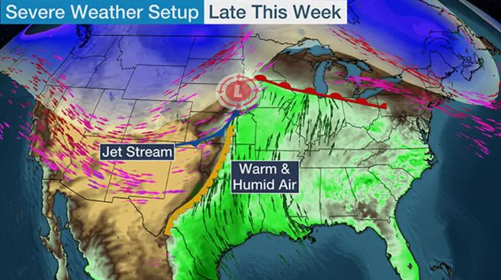
Important Takeaways:
- A significant outbreak of severe weather, including the risk of some nocturnal tornadoes will unfold by Tuesday and continue on Wednesday which will put lives and property at risk in the central and eastern U.S.
- As an early March storm strengthens from Monday night to Wednesday night, severe thunderstorms will extend across nearly two dozen states, and associated impacts may affect 170 million people from the southern Plains to the Midwest and East, AccuWeather meteorologists warn.
- The main threat from severe weather will be powerful wind gusts that can knock over trees and cut the power in some communities from Texas and Oklahoma to portions of Florida, Michigan, New York, Pennsylvania and New Jersey. There is also a risk of a dozen or two tornadoes spinning up in the strongest storms, and part of that threat will exist during the nighttime hours in the Central states.
- Wind energy from the storm will first be felt over portions of the southern Rockies and Plains beginning at the end of the weekend. Gusts frequenting 50-70 mph in the mainly clear, dry air, combined with the dry winter brush, will significantly boost the risk of wildfires through Tuesday.
- As a trailing cold front associated with the storm begins to encounter moisture from the Gulf late Monday night, thunderstorms will erupt.
- At this early stage of the severe weather outbreak, the main threat will be from powerful wind gusts during Monday night from central Texas to much of Oklahoma and southern Kansas. However, this will only mark the beginning or ramp-up phase of the severe weather.
- AccuWeather meteorologists believe there is a high risk of severe weather that represents a widespread threat from northeastern Texas to southwestern Tennessee. This area may also be the most prone to tornadoes, with that threat continuing after dark, adding to the danger.
- From Tuesday to Tuesday night, a massive area with few to numerous severe thunderstorms will extend from south Texas to Kansas, Missouri, Illinois, Indiana, Ohio and the Florida Panhandle. In addition to the likelihood of high winds and a few tornadoes, some of the storms will produce damaging hail and lightning, as well as flash flooding.
- As the storm lifts northward toward the Upper Midwest, the threat of severe weather will be carried into the Great Lakes region, part of the Atlantic Seaboard and the northeast Gulf coast on Wednesday and Wednesday night. There can even be thunder and lightning with gusty winds as far to the north as the St. Lawrence Valley and eastern New England.
Read the original article by clicking here.

Important Takeaways:
- Hundreds of people in a southern Illinois town were ordered to evacuate Tuesday as water rolled over the top of a dam, just one perilous result of severe weather that raged through Midwest overnight with relentless rain and tornadoes and hit the Chicago area especially hard.
- Hundreds of thousands of people lost power, and even weather forecasters had to briefly scramble for safety.
- A woman in Indiana died after a tree fell on a home Monday night.
- Water overtopped a dam near Nashville, Illinois, sending first responders out to ensure everyone got out safely. There were no reports of injuries in the community of 3,000, southeast of St. Louis, but a woman reported water up to her waist in her home, said Alex Haglund, a spokesperson for the Washington County Emergency Management Agency.
Read the original article by clicking here.

Important Takeaways:
- Second destructive derecho in a week slams central US with 100-mph winds, baseball-sized hail
- On Thursday, a derecho plowed across parts of Texas and Louisiana, blasting the Houston metro area with winds up to 100 mph that left at least seven people dead and more than 1 million customers in the dark.
- Cleanup efforts are underway across parts of the central U.S. after a destructive derecho blasted across Kansas with 100 mph wind gusts and baseball-sized hail, causing major damage and knocking out power to tens of thousands of utility customers across the region.
- This is now the second derecho in a week to blast parts of the U.S. On Thursday, a derecho plowed across parts of Texas and Louisiana, blasting the Houston metro area with winds up to 100 mph that left at least seven people dead and more than 1 million customers in the dark.
- Damaging wind reports stretch more than 400 miles across Kansas
- Millions of people from the Plains to the Midwest will be on alert for powerful thunderstorms capable of producing damaging wind gusts, large hail and possible tornadoes.
- The highest threat of severe weather will be found across portions of the Plains on Monday, but the potential for powerful storms will also have people in cities like Chicago, Milwaukee and Des Moines in Iowa on alert.
Read the original article by clicking here.

Important Takeaways:
- Heightened tornado risk targets Nashville as severe weather outbreak expands to nearly 150 million Wednesday
- Nearly 4 million people, including the cities of Nashville in Tennessee and Bowling Green in Kentucky, are included in a Level 4 out of 5 risk of severe weather. Another 14 million are included in a Level 3 out of 5 risk, including Memphis in Tennessee and St. Louis in Missouri.
- The nation’s deadly severe weather outbreak enters its third day with a higher risk of strong, long-track tornadoes in densely populated areas.
- This comes as several damaging twisters tore across the Midwest and Ohio Valley on Tuesday, with Michigan being the hardest hit.
- Tornadoes, very large to giant hail and destructive wind gusts are all possible. Some of the tornadoes may be EF-2 or stronger.
- “Mayfield, Kentucky, is right in the middle of this. That is always a concern when you see those towns that have been hard hit by severe weather in the last three years or so,” FOX Weather Meteorologist Britta Merwin said. “It takes a lot of time to come back from an EF-4 tornado.”
- [According to a Fox graphic: (May 7-8) 126 sever T- Storm warnings, 68 Tornado Warnings, 1 Tornado Emergency]
Read the original article by clicking here.
Luke 21:25 ““And there will be signs in sun and moon and stars, and on the earth distress of nations in perplexity because of the roaring of the sea and the waves
Important Takeaways:
- Severe Thunderstorms With Hail, High Winds Possible In Plains, South
- A threat of severe thunderstorms is back in the nation’s midsection and South this week.
- Scattered severe thunderstorms are most possible from parts of northeast Kansas into southeast Nebraska, Iowa and northwest Missouri, including a few of the same areas affected by severe storms last Friday.
- The majority of these storms should flare up early Wednesday evening and night. Large hail is the main threat, with some destructive hail possibly larger than baseballs. Damaging wind gusts and a few tornadoes are also possible.
- Any storms farther south into the areas shaded in Oklahoma and Texas could be more isolated or might not occur at all during the late afternoon or evening. Large hail and perhaps a strong wind gust are the main concerns if any of these storms can punch through an inhibiting cap.
Read the original article by clicking here.

Revelation 16:9 “They were scorched by the fierce heat, and they cursed the name of God who had power over these plagues. They did not repent and give him glory.”
Important Takeaways:
- Southern Severe Weather: At Least Two People Dead, Multiple Tornadoes Reported
- At least two people have died in the outbreak.
- An eyewitness describes a tornado in Bassfield, Mississippi.
- Reports of severe weather stretched from Texas to Kentucky.
- Two Deaths Confirmed In Montgomery County, Alabama
- Damage in Elmore County, Alabama
- Injuries Reported in Montgomery, Alabama
- Damage In Choctaw County, Mississippi
- Eyewitness Account Of Tornado In Bassfield, Mississippi
Read the original article by clicking here.

Revelation 16:9 “They were scorched by the fierce heat, and they cursed the name of God who had power over these plagues. They did not repent and give him glory.”
Important Takeaways:
- Thousands of flights delayed or cancelled after severe weather sets off travel chaos as millions of Americans head home after Thanksgiving holiday
- More than 6,098 flights were delayed and 173 were canceled as of Sunday night
- A severe weather system is to blame for many of the delays and cancelations as travelers tried to get back home after the Thanksgiving holiday
- Airports in three major cities – New York City, Washington D.C., and Boston – appear to be the most affected.
- Airlines had prepared for an estimated 4.5M to fly this Thanksgiving holiday
- Earlier this month, the Transportation Security Administration announced it would cut the cost of enrolling in TSA PreCheck
Read the original article by clicking here.


