Be prepared as severe thunderstorms and high winds will pack a punch from the plains to the south

Luke 21:25 ““And there will be signs in sun and moon and stars, and on the earth distress of nations in perplexity because of the roaring of the sea and the waves

Important Takeaways:

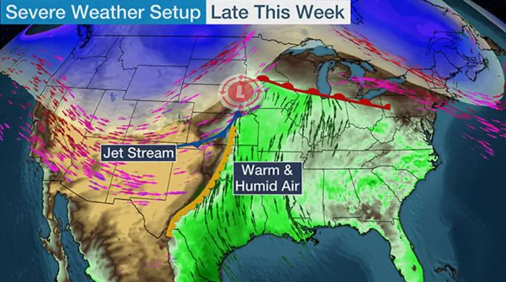
  • Severe Thunderstorms With Hail, High Winds Possible In Plains, South
  • A threat of severe thunderstorms is back in the nation’s midsection and South this week.
  • Scattered severe thunderstorms are most possible from parts of northeast Kansas into southeast Nebraska, Iowa and northwest Missouri, including a few of the same areas affected by severe storms last Friday.
  • The majority of these storms should flare up early Wednesday evening and night. Large hail is the main threat, with some destructive hail possibly larger than baseballs. Damaging wind gusts and a few tornadoes are also possible.
  • Any storms farther south into the areas shaded in Oklahoma and Texas could be more isolated or might not occur at all during the late afternoon or evening. Large hail and perhaps a strong wind gust are the main concerns if any of these storms can punch through an inhibiting cap.

Read the original article by clicking here.

Firefighters, military planes, troops arrive in California to fight massive blazes

By Dan Whitcomb

LOS ANGELES (Reuters) – Crews from across the U.S. West, military planes and National Guard troops poured into California on Sunday to join the fight against two dozen major wildfires burning across the state, as officials warned of more dry lightning storms approaching.

The worst of the blazes, including the second and third largest wildfires in recorded California history, were burning in and around the San Francisco Bay Area, where more than 200,000 people have been told to flee their homes.

“Extreme fire behavior with short and long range spotting are continuing to challenge firefighting efforts. Fires continue to make runs in multiple directions and impacting multiple communities,” the California Department of Forestry and Fire Protection said of the largest conflagration, the LNU Lightning Complex.

The fires, which were ignited by lightning from dry thunderstorms across Northern and Central California over the past week, have killed at least six people and destroyed some 700 homes and other structures. All told nearly one million acres have been blackened, according to Cal Fire.

Smoke and ash has blanketed much of the northern part of California for days, drifting for miles and visible from several states away.

The LNU Complex, which began as a string of smaller fires that merged into one massive blaze, has burned across roughly 340,000 acres of Napa, Sonoma, Lake, Yolo and Solano counties, Cal Fire spokesman Daniel Berlant said at a news briefing on Sunday.

It is now the second-largest wildfire on record in the state and was only 17% contained as of Sunday afternoon. To the south the SCU Lightning Complex was nearly as large, at 339,000 acres, and only 10% contained, Berlant said.

CREWS ARRIVE FROM OTHER STATES

Outside the Bay Area, the flames were threatening forests near the University of California at Santa Cruz and a wide swath of the area between San Francisco and the state capital of Sacramento.

Reinforcement crews and fire engines have arrived from Arizona, Montana, Nevada, Texas and Utah, with more on the way, Berlant said. Some 200 members of the National Guard had been activated and the U.S. military sent planes, he said.

U.S. President Donald Trump on Saturday declared the fires a major disaster, freeing up federal funds to help residents and businesses harmed by the fires in seven counties pay for temporary housing and repairs.

Berlant said more dry thunderstorms were forecast through Tuesday and so-called red flag warnings had been issued across much of the northern and central parts of California during a record-breaking heat wave that has baked the state for more than a week, caused by a dome of atmospheric high pressure hovering over the American Southwest.

Meteorologists say that same high-pressure ridge has also been siphoning moisture from remnants of a now-dissipated tropical storm off the coast of Mexico and creating conditions rife for thunderstorms across much of California.

Most of the precipitation from the storms evaporates before reaching the ground, leaving dry lightning strikes that have contributed to a volatile wildfire season.

The American Lung Association has warned that the coronavirus pandemic has heightened the health hazards posed by smoky air and extreme heat. Inhaling smoke and ash can worsen the weakened lungs of people with COVID-19, said Afif El-Hassan, a physician spokesman for the lung association.

(Reporting by Dan Whitcomb; Editing by Daniel Wallis)

Lightning-sparked fires rage across California, tens of thousands flee

By Steven Lam

VACAVILLE, Calif. (Reuters) – A firefighting helicopter pilot was killed in a crash, and scores of homes burned in California on Wednesday as hundreds of lightning-sparked blazes forced tens of thousands of people to flee their dwellings.

Nearly 11,000 lightning strikes were documented during a 72-hour stretch this week in the heaviest spate of thunderstorms to hit California in more than a decade, igniting 367 individual fires. Almost two dozen of them have grown into major conflagrations, authorities said.

Multiple fires raced through hills and mountains adjacent to Northern California’s drought-parched wine country, shutting down Interstate 80 at Fairfield, about 35 miles (56 km) southwest of Sacramento, as flames leapt across the highway, trapping motorists caught in a hectic evacuation.

Police in the nearby town of Vacaville reported that advancing flames had prompted the evacuation of a state prison there and a medical facility for inmates.

Four residents whose communities were overrun by flames hours earlier in the same area suffered burns but survived, though the severity of their injuries was not immediately known, said Will Powers a spokesman for the California Department of Forestry and Fire Protection (CalFire).

He said thousands of residents were under mandatory evacuation orders in a four-county area stricken by a cluster of nine wind-driven fires collectively dubbed the LNU Complex, triggered by lightning on Monday.

In central California, a helicopter was on a water-dropping mission in Fresno County about 160 miles (258 km) south of San Francisco when it crashed, killing the pilot, a private contractor, CalFire said.

As of Wednesday night, the LNU complex of fires had burned largely unchecked across 124,000 acres (50,000 hectares), with zero containment, destroying at least 105 homes and other structures and leaving another 70 damaged, CalFire said. Several of the fires had merged by nightfall.

Wearing a singed nightgown, Diane Bustos said her husband abandoned their car as it caught fire and then blew up on the west side of Vacaville early Wednesday morning. She lost both her shoes when she and her family ran for their lives.

“I made it, God saved me,” Bustos told television station KPIX.

There were social media accounts of people trapped in the blaze, but CalFire’s Powers said authorities had no reports of anyone missing.

A Reuters reporter saw dozens of burned-out homesteads and houses in the Vacaville-Fairfield area, dead livestock among torched properties and some animals wandering loose.

“We are experiencing fires the like of which we haven’t seen in many, many years,” California Governor Gavin Newsom told a news conference, adding he had requested 375 fire engines from out of state to help.

He declared a statewide fire emergency on Tuesday.

The last time California experienced dry lightning storms of such devastating proportions was in 2008, said CalFire spokesman Scott Maclean.

Fanned by “red-flag” high winds, the fires are racing through vegetation parched by a record-breaking heat wave that began on Friday. Meteorologists have said the extreme heat and lightning storms were both linked to the same atmospheric weather pattern – an enormous high-pressure area hovering over America’s desert Southwest.

The largest group of fires, called the SCU Lightning Complex, had scorched at least 102,000 acres some 20 miles east of Palo Alto, while a third cluster, the CZU August Lightning Complex, grew to more than 10,000 acres and forced evacuations around 13 miles south of Palo Alto.

(Reporting by Steven Lam in Vacaville, Calif.; Additional reporting by Jane Ross and Steve Gorman in Los Angeles and Sharon Bernstein in Sacramento. Writing and reporting by Andrew Hay in Taos, New Mexico; Editing by Stephen Coates, Sandra Maler and Lincoln Feast.)

Australia’s bushfire-stricken east welcomes drenching rain

By Lidia Kelly

MELBOURNE (Reuters) – Intense thunderstorms with heavy rains dampened bushfires on Australia’s east coast on Friday, to the relief of exhausted firefighters and farmers battling years of drought, and granting a reprieve to the organisers of next week’s Australian Open.

Australia, famous for its pristine beaches and wildlife, has been fighting bushfires since September, with fires killing 29 people and millions of animals, and destroying more than 2,500 homes while razing an area roughly a third the size of Germany.

Victoria, New South Wales and Queensland, three of the states most affected by drought and bushfires welcomed this week’s drenching rain, with fire services saying it would not extinguish all the blazes, but would greatly aid containment.

“Our fingers are crossed that this continues over the coming days,” New South Wales fire services said on Twitter on Friday.

Severe storms are forecast to continue in many fire-stricken regions of New South Wales and Queensland, including areas that have not seen heavy falls for years, weather officials in New South Wales said, slightly easing a three-year drought.

“The recent rain has just been absolutely fantastic,” said cattle farmer Sam White near the northern town of Guyra in New South Wales.

“It’s producing significant amounts of runoff, which is what we need, and it’s getting into our dams.”

While the wet weather brings relief to fire fighters and drought-hit farmers, it also comes with dangers, such as flash flooding and falling trees. One wildlife park had to rescue koalas from floodwaters and beat back crocodiles with brooms.

The heavy downpours have helped to clean smoky air in Australia, but Sydney, Canberra and Melbourne remained in the world’s top 100 polluted cities on Friday, a pollution ranking by AirVisual showed.

Melbourne, shrouded this week in thick smoke that disrupted the Australian Open qualifying matches and other competitions, is forecast to again be blanketed by unhealthy air over the weekend, before the Grand Slam begins in earnest on Monday.

But fears the smoke would return on Saturday for the final round of qualifying eased on Friday, when the Environmental Protection Agency forecast air quality in the Melbourne area would be “moderate” rather than “very poor”.

The smoke haze plaguing Australia’s major cities for weeks has been tracked by NASA circumnavigating the globe and the space agency’s satellites showed on Thursday there was also a large concentration of lower smoke over the Pacific Ocean.

Here are key events in the bushfire crisis:

* Early on Friday, 82 fires were burning across New South Wales, 30 uncontained, and several in Victoria, fire authorities said.

* An emergency evacuation order was issued for parts of Victoria’s northeast, with an out-of-control bushfire threatening the Buffalo River Valley.

* Firefighters, family and the community of Holbrook in New South Wales bade farewell to Samuel McPaul, a 28-year-old volunteer who died in December while fighting a massive and fast-moving blaze.

* Australia will have to wait until March for rains heavy enough to bring sustained relief from dry weather that has fuelled the bushfires, the weather bureau said.

* Top tourism body estimates the bushfire crisis has cost the Australian industry almost A$1 billion ($690 million). [L4N29L069]

* Players’ complaints about pollution blighted qualifying rounds of the Australian Open in Melbourne, the year’s first tennis Grand Slam.


(Reporting by Lidia Kelly; Editing by Michael Perry and Clarence Fernandez)

U.S. south ‘still under the gun’ after deadly storms

A storm cloud formation is seen in Collinsville, Oklahoma, U.S., May 20, 2019 in this picture obtained from social media on May 21, 2019. BRI'ANNE WALTON/via REUTERS

By Rich McKay

(Reuters) – A storm system that blasted the U.S. South was weakening on Tuesday but another was on its way after thunderstorms and tornadoes left a swath of destruction, killed at least two people and tore up a NASCAR grandstand.

More than 30 tornadoes struck on Monday and Tuesday from Texas, Oklahoma and across the southern plains into Missouri, said meteorologists with the National Weather Service.

While this weakening storm system is expected to roll into the Great Lakes region early Wednesday, another system is brewing Wednesday night into Thursday, said Brian Hurley, a forecaster with the NWS Weather Prediction Center.

“The Southern Plains can’t catch a break,” Hurley said. “More storms will develop overnight into Thursday morning.”

Rainfalls are predicted to be about 2 inches across eastern Kansas, Oklahoma, and into western Missouri, with localized spots getting up to 5 inches, he said.

“That whole area is still under the gun,” Hurley said.

In Wheatland, Missouri, at the Lucas Oil Speedway, a reported tornado injured 7 people, flipped over cars, toppled campers and damaged the grandstands, with local media images showing piles of twisted metal and upside down vehicles.

The Memorial Day weekend “Lucas Oil Show-Me 100” races at the speedway, about 120 miles southeast of Kansas City, were canceled indefinitely. A crowd topping 3,000 fans of the National Association for Stock Car Auto Racing (NASCAR) had been expected, track officials said on Tuesday.

Dozens of people were rescued from rising floodwaters and felled trees that smashed homes and blocked roadways in Oklahoma on Tuesday.

Crews using boats pulled at least 50 people from rising water as heavy downpours inundated roads and homes, Oklahoma Emergency Management Agency spokeswoman Keli Cain said.

Two deaths from a traffic accident on a rain-slicked Missouri highway were reported by police late Monday.

Missouri Gov. Mike Parson declared a state of emergency on Tuesday for the state, out of concern for floods from cresting rivers and streams, with forecasts of more rain on the way.

Forecasters said the Missouri River is expected to crest on Thursday at more than 32 feet at the state capital of Jefferson City. Local media including NBC News said that is two feet higher than the city’s levees.

(Reporting by Rich McKay in Atlanta; additional reporting by Brendan O’Brien in Milwaukee and Dan Whitcomb in Los Angeles; Editing by Peter Graff)

Second wave of twisters in U.S. South turns deadly as storm pushes east

4-19-2019 Twitter photograph of Macron, MS twitter - Bryce Jones

By Rich McKay

(Reuters) – A second wave of tornadoes and thunderstorms to hit the U.S. South and Midwest this week turned deadly on Thursday with three people reported killed, as the storms pushed eastward on Friday, officials and media accounts said.

One person was killed after a tree fell on his vehicle in Neshoba County, Mississippi, Thursday afternoon, the local paper, the Neshoba Democrat, reported.

A second death was reported in St. Clair County, Mississippi, after a tree fell on a home, late Thursday, according to AccuWeather.

A third death was reported late Thursday in the Wattsville community, north of Pell City, Alabama, the National Weather Service (NWS) reported, after a tree fell on a home.

The deaths come in the wake of at least five people, including three children, who were killed last weekend in a storm system that drove more than three dozen tornadoes across the U.S. South.

Communities in central Texas and western Louisiana, already hit by flash floods and twisters in the first round last weekend, were hit once more by high winds, twisters, egg-sized hail and intense rain Thursday and Friday, according to AccuWeather and the NWS.

In the latest storm system, multiple possible tornadoes hit southwest and central Mississippi Thursday night and early Friday, the NWS said, but the damage will have to be surveyed before confirmation of twisters.

“We’re still under some severe storm warnings, tornado watches and flood warnings into this morning and the afternoon across a broad swipe of the U.S.,” said NWS meteorologist Bob Oravec early Friday.

“The severe thunderstorms will impact the deep South and southeastern U.S., through Georgia and the Florida panhandle, before it heads up the Atlantic Coast,” he said.

Flash flooding could remain a threat in Maine, New Hampshire and Massachusetts on Saturday, the weather service said.

The storm system will lose much of its punch late in the weekend, but the East Coast should expect a soggy Easter, Oravec said.

Power outages were reported early Friday in Texas, Mississippi, Alabama and Tennessee, affecting a total of about 91,800 homes and businesses, according to the tracking site PowerOutage.Us.

(Reporting by Rich McKay; Editing by Mark Potter)

Second wave of tornadoes, thunderstorms to pummel the U.S. South and Midwest

National Weather forecast for 4-17-19

(Reuters) – Tornadoes and thunderstorms will hit the U.S. South and Midwest for a second time this week, starting Wednesday afternoon and pushing eastward, forecasters said.

At least five people, including three children, were killed over the weekend in a storm system that drove more than three dozen tornadoes across the U.S. South.

Communities in central Texas and western Louisiana, already hit by flash floods and twisters in the first round, will be hit once more by high winds, twisters and intense rain, according to AccuWeather and the NWS.

“This is a dangerous, vigorous storm,” Jim Hayes, a meteorologist with the National Weather Service’s Weather Prediction Center in Maryland, said early Wednesday.

The storm is expected to stretch from Iowa and Missouri in the north through Kansas, Oklahoma and Texas to the south, said AccuWeather Senior Meteorologist John Feerick.

“Dallas and Oklahoma City, from there on eastward is probably at greatest threat from damaging winds, flooding downpours and tornadoes,” said Feerick.

Northern Oklahoma could be pelted with hail 2 inches (5 cm) in diameter, or larger, on Wednesday, the NWS tweeted.

NWS forecaster Hayes said the storm gets its initial fuel from warm, moist air over the Gulf of Mexico.

“It’ll kick-up this afternoon over southern Kansas and about all of Oklahoma, with rain, wind gusts of 65 mph, hail and tornadoes.”

“The worst will hit before midnight,” he added. “By early Thursday it’ll push into Kentucky and Alabama.”

As the storm tracks eastward, it will extend from Indiana south to Florida by late Thursday, hitting the Atlanta area that night and the Atlantic coast the next day.

Picking up moisture from the ocean, the system is likely to produce intense thunderstorms up the eastern seaboard as far north as New York state.

New York City, Philadelphia and Washington may face travel delays from the rain and possibly property damage from high winds, AccuWeather warned.

Flash flooding could remain a threat in Maine, New Hampshire and Massachusetts on Saturday, the weather service said.

(Reporting Andrew Hay in Taos, New Mexico and Rich McKay in Atlanta; Editing by Raissa Kasolowsky)

Firefighters gain on California wildfires as weather cooperates

A USGS geologist making observations of the fissure 8 lava channel at sunset is pictured in this July 3, 2018 fisheye lens handout photograph near the Kilauea volcano eruption in Hawaii, U.S. USGS/Handout via REUTERS

(Reuters) – Firefighters are gaining momentum as they battle several wildfires that have destroyed dozens of homes and forced the evacuation of thousands of residents in California.

Across the state, milder weather over the last couple of days has helped firefighters to hold the line against several blazes, allowing them to lift evacuation orders for residents forced to flee their homes.

Temperatures are expected to fall this week in parts of the state, the National Weather Service said, after scorching heat, high winds and low humidity fanned dozens of fires this summer in a particularly intense fire season across the U.S. West.

“The weather is starting to cooperate, so it’s letting firefighters get the upper hand on the fires,” said Lynette Round, a spokeswoman for the California Department of Forestry and Fire Protection, called Cal Fire.

U.S. wildfires have already burned more than 3.3 million acres (1.3 million hectares) this year, more than the annual average of about 2.6 million acres over the past 10 years, according to the National Interagency Fire Center.

One person has been killed and three firefighters injured in a wildfire on the California-Oregon border. That blaze, the Klamathon Fire, has torched 36,500 acres (14,770 hectares) and destroyed 82 homes since erupting on Thursday.

Shifting wind patterns remained a concern, but that fire was not expected to grow significantly overnight, a spokesman for Cal Fire said.

In western Nevada, a fire weather watch will be in effect on Wednesday as winds up to 50 miles (80 km) per hour and thunderstorms with lightning are expected in the area.

Elsewhere in the U.S. Southwest, dozens of active fires remained burning, including the 107,900-acre Spring Creek Fire, which is on pace to become the second-largest fire in Colorado’s history, according to the Denver Post newspaper.

“Near critical fire weather conditions are possible across portions of eastern Colorado Tuesday afternoon,” the National Weather Service said in an advisory.

Showers and thunderstorms are also in the forecast for parts of the region through Wednesday, the weather service said, warning of lightning and gusty winds that could create and fan wildfires.

(Reporting by Brendan O’Brien in Milwaukee, editing by Larry King)

Power outages linger as U.S. Northeast recovers from deadly storm

Commuters wait as service was temporarily suspended on all Metro North lines at Grand Central Terminal due to storms in Manhattan, New York, May 15, 2018. REUTERS/Herbert Lash

NEW YORK (Reuters) – A violent spring storm that killed at least five people in the northeastern United States downed trees and power lines, leaving hundreds of thousands of people without power on Wednesday.

By daybreak, more than 370,000 residents were without power in New York, New Jersey, Connecticut and Pennsylvania, down from more than 600,000 on Tuesday night.

Amtrak and most local commuter railroads in the New York metropolitan area said their services were back to normal on Wednesday. Some schools canceled classes or delayed their openings.

The line of strong thunderstorms with wind gusts of 50 to 80 miles per hour (80 to 129 kilometers per hour) sped eastward across the region Tuesday evening, causing local flooding, scattering debris and dropping hail as large as tennis balls.

Falling trees killed an 11-year-old girl and a woman in separate incidents in Newburgh, New York, police said. Falling trees also killed two people in Connecticut in separate incidents, as well as a person in Pennsylvania, local media reported.

Local news showed footage of trees resting on top of crushed cars and houses, and vehicles submerged in water.

There were more than 100 reports of hail in states including Ohio, Pennsylvania, New York and Connecticut, the National Weather Service said.

New York Governor Andrew Cuomo declared a state of emergency in several counties in southeast New York and deployed members of the New York National Guard to assist with the recovery.

Officials in Brookfield, Connecticut, declared a town disaster and told residents to stay inside until they could assess the damage.

“Please be aware that there are hundreds of downed trees, utility poles and electrical lines. AVOID all down trees and utility poles as they may still involve LIVE power lines,” the Brookfield Police Department said on Facebook.

(Reporting by Peter Szekely in New York and Brendan O’Brien in Milwaukee; Editing by Alison Williams and Susan Thomas)

Storms move east after killing three in U.S. Midwest

By Brendan O’Brien

MILWAUKEE (Reuters) – Tornadoes and storms that already have killed at least three people and destroyed homes in the U.S. Midwest are moving east on Wednesday, the National Weather Service and media reported.

Tornado watches remained in effect from northeast Arkansas north into Ohio and eastern Pennsylvania for Wednesday morning after the band of storms rolled through the Midwest on Tuesday night, the National Weather Service said.

“Widespread damaging winds can be expected, along with some tornado risk,” the service said in an advisory.

The storm system will continue moving east toward the Atlantic Ocean, according to AccuWeather meteorologists. This is likely to bring severe thunderstorms and possible travel delays later on Wednesday to New York City, Washington, Philadelphia and Boston.

The storm has left tens of thousands of people without electricity and killed at least three people, according to local officials and media reports. One person died while driving on a Missouri freeway after strong winds swept old cars from a nearby junkyard onto the road.

Tornado spotters have already reported at least 23 twisters in Illinois, Missouri, Iowa, Tennessee and Indiana on Tuesday evening, the National Weather Service said.

(Reporting by Brendan O’Brien; Additional reporting by Jonathan Allen in New York; Editing by Lisa Von Ahn)