Important Takeaways:
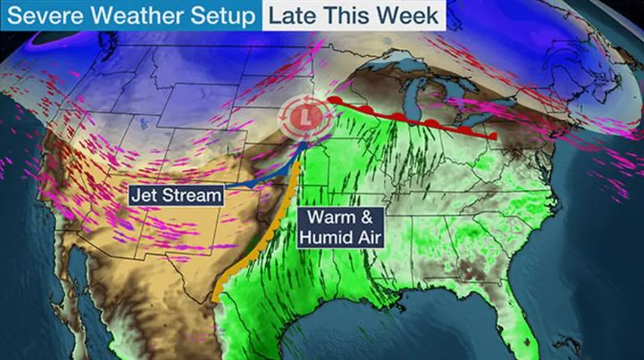
- A mammoth and multifaceted storm – which was dealing wind, fire, choking dust and the threat of a blizzard – is pummeling much of the country as it marches east.
- Here’s the latest:
- Deep South feeling the punch: A line of damaging storms moving through Alabama, Georgia and the Florida Panhandle overnight will continue to head east Wednesday, bringing a threat of strong winds and a few tornadoes.
- East Coast braces for impacts: The storm is expected to bring its strongest to the Carolinas and Mid-Atlantic by Wednesday afternoon, bringing strong winds and a chance of tornadoes from Charleston, South Carolina, up to Norfolk, Virginia. Lower storm threats are possible from Florida to southern New York, which could see gusty winds, rain and hail.
- Fires in Texas: Dozens of fires have erupted across Texas amid a critical fire risk across a large portion of the state. High winds in Atascosa County resulted in several house fires Tuesday afternoon, law enforcement officials said.
- Blizzard conditions possible: Heavy snowfall and gusty winds will remain across the Midwest through Wednesday afternoon. This will mean possible blizzard conditions in more populated areas, including Kansas City, Omaha, Nebraska; Des Moines, Iowa; and perhaps Minneapolis. Gusts of 50-70 mph are expected in some areas.
- Widespread power outages: Severe thunderstorms with intense damaging wind gusts are roaring across the South. Wind gusts in excess of 70 mph have occurred in states, including Texas and Oklahoma. More than 500,000 homes and businesses were without power across central US, the Southeast and parts of the Midwest by early Wednesday, according to PowerOutage.us.
- Dust storm: Officially called a haboob, the fast-moving wall of dust and debris was still blowing across the region Tuesday as strong winds moved across the region, especially in Texas. The winds have since died down from 45 mph to below 10 mph across much of the region.
Read the original article by clicking here.