Power outages and car accidents across the south as Ice Storm barrels down

Luke 21:25-26 “And there will be signs in sun and moon and stars, and on the earth distress of nations in perplexity because of the roaring of the sea and the waves, people fainting with fear and with foreboding of what is coming on the world. For the powers of the heavens will be shaken.

Important Takeaways:

  • Death toll climbs, power outages remain rampant during southern US ice storm
  • At least eight people have now died from storm-related crashes in Texas and Arkansas, and two law enforcement officers have been seriously injured since Monday, The Associated Press reported.
  • The weight of ice on trees and power lines caused power outages to rise overnight. As of 5 a.m. CST, more than 400,000 customers across four states are in the dark. The majority of the outages were in Texas, with over 390,000 without power. According to PowerOutage.US, over 165,000 of the outages were in Travis County. This county is the home to the city of Austin. Freezing rain is continuing to fall in Texas, Arkansas, Tennessee and Mississippi this morning, so the power outage number may rise further before crews have a chance to restore electricity.

Read the original article by clicking here.

At least one dead in numerous car crashes in icy New England

connecticut state police

By Scott Malone

BOSTON (Reuters) – An unexpected bout of icy weather on Wednesday morning caused scores of accidents around New England, with 55 vehicles colliding in a series of crashes outside Boston and a man killed in a separate incident.

Police in Needham, Massachusetts, said a vehicle struck and killed a 63-year-old man who had been trying to help another motorist stuck on the ice in the suburb about 18 miles (29 km) west of Boston.

“It appears as though the vehicle was sliding on the ice and was unable to stop before striking the victim, pinning him between the two vehicles,” the Needham Police Department said in a statement. It did not identify the victim.

North of Boston, some 55 cars were involved in a series of crashes in the suburb of Wakefield, Massachusetts, with multiple motorists injured, though none seriously, state police said.

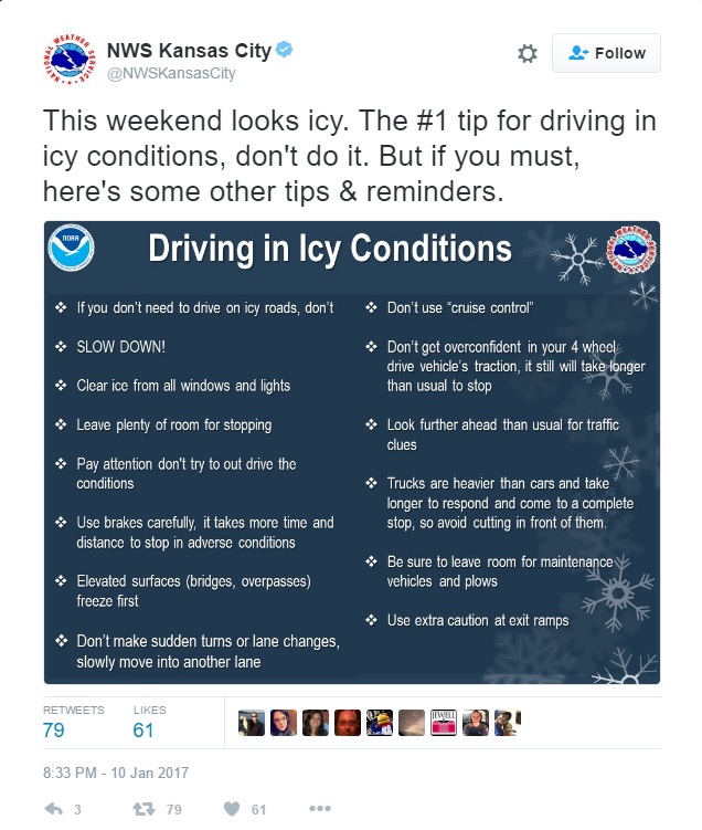
It was the start of a forecast whipsaw of weather over 48 hours. Temperatures around Boston are expected to pass 50 degrees Fahrenheit (10°C) on Wednesday before dropping back below freezing overnight, when a snowstorm is expected to begin.

The National Weather Service was forecasting 8 to 14 inches (20-36 cm) of snow on Thursday.

Wednesday’s ice, the result of an overnight rainstorm, may have caught commuters off-guard since earlier forecasts had anticipated temperatures would rise above freezing before the snow begins, said National Weather Service meteorologist Bill Simpson.

The result was chaos on roads around Massachusetts, Connecticut and New Hampshire.

Photos from the Wakefield area showed vehicles spun at strange angles and entirely blocking the roadway, with emergency responders having trouble maintaining their footing on icy roads.

The Massachusetts State Police had not yet counted the total number of traffic collisions around the state, a dispatcher said.

Massachusetts Governor Charlie Baker ordered a two-hour opening delay for state offices.

“Exercise extreme caution,” Baker said, “as driving is very difficult due to icy conditions.”

Farther north, all but one lane of a major interstate highway in Maine was closed after a tractor-trailer that ran off the road and flipped on its side due to the ice. Work crews were removing its cargo, bags of potatoes, before attempting to lift the vehicle off its side, a state police spokesman said.

(Reporting by Scott Malone; Editing by Lisa Von Ahn)

Ice storm targets central United States

empty runway at natioanal airport due to ice

Reuters) – An ice storm heading for the central United States is threatening to cause power outages and create treacherous travel conditions on Friday and into the weekend, the National Weather Service said.

Ice, freezing rain and winter storm warnings were in effect for a large swathe of the Plains, from the Texas panhandle north into Iowa and east through central Indiana, the Weather Service said in an advisory.

“Significant amounts of ice accumulations will make travel dangerous or impossible,” the weather service said. “Travel is strongly discouraged. Commerce will likely be severely impacted.”

Ice accumulation could be more than half an inch (1 cm) depending on local temperatures, creating slick roadways especially on bridges and overpasses, and possibly causing scattered power outages across the region, the service said.

Oklahoma Governor Mary Fallin declared a state of emergency for the entire state ahead of the storm.

“Emergency personnel are coordinating with state and local officials to ensure we are prepared and ready for whatever comes our way,” said Fallin.

A handful of public school districts and universities in Idaho, Oklahoma and other parts of the central region have either canceled classes on Friday or had delayed openings due to the impending storm.

Parts of the region could also see as much as 3 inches (8 cm) of snow later in the weekend, according to the forecast.

(Reporting by Brendan O’Brien in Milwaukee; Editing by Janet Lawrence and Bernadette Baum)

Preparation and driving tips for incoming Midwest ice storm

By Shirette Stockdall

Multiple weather services (including The Weather Channel, AccuWeather, and the National Weather Service) are reporting a widespread ice storm to hit the U.S. Midwest this weekend. Winter storm watches have been placed in several counties ranging from Texas to Ohio. This storm is expected to bring freezing rain/sleet starting Friday, January 13th and continue throughout the region until Tuesday, January 17th.

The Weather Channel reports that the storm will slowly move north throughout the weekend. Radar shows that the storm will hit Oklahoma, Kansas, Missouri, Illinois, and Indiana with the most ice. By Monday, the freezing rain/sleet will move north, hitting Iowa, Wisconsin, and Michigan until Tuesday.

Despite the storm moving across the Midwest, meteorologists warn that ice accumulation could get up to half an inch. This is more than enough to weigh down trees and damage power lines, meaning that hundreds of thousands could be without power during the weekend, according to The Weather Channel. Ice will also accumulate on the roads, leading to dangerous driving conditions.

The National Weather Service is warning drivers to stay off the roads, but also provided driver safety tips on Twitter for those who do have to brave the storms.

Additionally, multiple weather services are advising residents in these regions to stock up on preparation items for the storm. These items include:

Flashlights, candles
Batteries
Battery powered radio
Extra Prescriptions/medications
First Aid Kit
Bottled Water
Nonperishable Food
Extra fuel for your generator
A cooler with ice to store cold foods
Extra blankets/warm clothes
Extra toiletries
Cash

Other actions can be taken to prepare for the storm. Make sure to charge all electronics before the power could possibly go out. If you have a generator, run it before the storm hits, make sure it has plenty of fuel or is full charged, and train all family members to be able to operate it. Teach family members basic first aid. Unplug sensitive appliances before the storm hits. If your house will be without heat for a couple days, make sure to drain all of your water pipes to avoid bursts. And if you do lose power, keep your refrigerator closed. Frozen food will keep for approximately 48 hours in the fridge, even without power.

Stay safe and stay warm!

Bitter Cold Freezes Niagara Falls

While not completely frozen to the riverbed, Niagara Falls is putting on a display of winter beauty from the latest polar vortex.

The upper part of the waterfall has completely frozen in the bitter temperatures, creating the impression for the second time this winter that the legendary waterfall has completely frozen.

The water pressure keeps the falls from freezing to the riverbed meaning that under the stacks of ice the river continues to rage.  However, none of the running water can be seen flowing over the falls as sheets of ice blanket the rocks and hills surrounding the falls.

Temperatures in the area have been hovering between zero and 9 degrees this week.

The cold freezing the falls is not the only record cold.  In Iowa, Des Moines broke a low temperature record set in 1884.  Atlantic City set a record not only for March 3rd but also for the entire month of March with 2 above zero, breaking a record dating back to 1874.  Several towns around Washington DC also shattered records.

Major Ice Storm Strikes South; Snow Hits East

Parts of the deep south found themselves coated in ice Monday morning while residents along the east coast are digging out from up to a foot of snow.

Airports from Kansas City, Missouri through Washington, DC saw the delay or cancellation of thousands of flights because of a band of snow that covered over half the nation.  Parts of St. Louis and Indianapolis had area receive as much as a foot of snow while surrounding areas saw three to six inches.

The snowfall turned to sleet and ice further south.  Parts of Arkansas, southern Tennessee and northern Mississippi faced power outages and impassable roads with some locations coated in more than an inch of ice.

Weather forecasters say the snow removal and ice removal will be harder than normal because of the weight of the ice and snow.  Heavy moisture from the Gulf of Mexico helped fuel the storm.

“Crippling Ice Totals” Possible In Atlanta

The second winter storm in two weeks is likely to bring “crippling ice totals” to Atlanta and parts of the east coast Wednesday.

The National Weather Service said some areas could end up with 18 inches of precipitation as a result of Winter Storm Pax.  While most of the Carolinas will receive snow, Georgia officials are preparing for up to an inch of ice.

Over 86,000 residents in the southeast have already lost power because of the storm and tens of thousands likely will lose power before the end of the day Wednesday.

Seven deaths have been directly attributed to the storm.  Over 75 percent of the flights from Atlanta’s Hartsfield-Jackson International Airport were canceled due to the weather.  The number is expected to climb through the day Wednesday.

Alabama and Georgia were under states of emergency because of the storm.  Alabama officials reported ice starting to build up on vehicles and power lines early Wednesday morning as the storm moves east.  In some parts of Georgia, a half inch of ice has already accumulated on trees and power lines before the bulk of the storm.

National Guard troops in Georgia are on stand by to evacuate nursing homes or hospitals if power lines go down.  Georgia officials say it’s possible to have “catastrophic” problems with the power grid.

Texas, Louisiana Covered In Ice

Southern Texas is facing a rare coating of ice as temperatures continue to plummet to record lows.

“The crazy thing is that the current cold snap this week looks to be a bit more modest in the face of next week’s outbreak,” Matt Rogers of the Commodity Weather Group told Bloomberg. “The cold coming for the end of January is sufficient to make this the coldest month of the century so far and the coldest the Lower 48 has felt in at least 20 years.”

Interstate 10 from Texas to Louisiana had to be closed because ice on the highway caused multiple accidents. State police warned residents to avoid the roadways as conditions deteriorated through the day Thursday and into Friday.

At least two deaths have been attributed to the icy accidents.

Louisiana Governor Bobby Jindal declared a state of emergency because of the storm.

Texas officials are warning residents Friday that even if the winter weather warnings have been lifted, roads and bridges can freeze and be ice covered after dark.

Southern Canada Hit By Weather-Created “Frost Quakes”

Canadians are experiencing a rare phenomenon as part of the polar vortex that has descended over the central part of North America.

Meteorologists call the incidents “frost quakes” and they can produce a sound as strong as a sonic boom.

The “quakes” happen when ice and rain seep into the ground and then the temperature falls so low that it freezes, causing the earth to split open as during an earthquake.

The phenomenon shocked residents of Toronto who thought someone was breaking into their homes or that gunfire had erupted in their neighborhoods. Toronto police reported hundreds of calls from worried residents over loud, unexplained noises.

Some residents told London’s Daily Mail that the quakes were strong enough to wake them from sleep and make dishes rattle.

First Snowfall In 100 Years Hits Cairo

The first snowfall in 100 years fell in Cairo leaving adults in awe of the sight and children playing in snow dusted parks. Other parts of the city were pelted by rain and hail during the storm.

The winter storm that rolled through the Middle East brought three feet of snow to Israel making roads into Jerusalem impassable and leaving much of the country without power. The snow was so heavy in the West Bank that olive trees buckled under the weight of the snow.

The storm drove waves to the point it hammered the Egyptian Mediterranean coast and fisherman in Alexandria were warned by officials it was too dangerous to put out to sea.

Syrian refugees in Lebanon were hit particularly hard by the storm as constructed shelters were not designed to deal with heavy snowfall and bitter cold.