Polar vortex, Midwest floods, California fires: The U.S.’s wild 2019 weather

By Brendan O’Brien

CHICAGO (Reuters) – From a brutal polar vortex that froze much of the Midwest and East Coast in January to Hurricane Dorian that killed dozens in the Bahamas in September, Mother Nature dealt Americans a wild and deadly weather year in 2019.

Weather events that made headlines this year included:

POLAR VORTEX BLAMED FOR 21 DEATHS

The year got off to a roaring start with a polar vortex that paralyzed the U.S. Midwest and the East Coast for several days at the end of January, putting tens of millions of Americans in a deep freeze. Arctic-like temperatures as low as minus 56 degrees F (-49 C) were blamed for at least 21 cold-related deaths, including nine in Chicago. The record-breaking cold snap shut schools and businesses, grounded hundreds of flights and filled emergency rooms with frostbite victims.

HISTORIC FLOODING SWAMPS U.S. PLAINS, MIDWEST

A quick-melting snow from a March “bomb cyclone” storm left wide swaths of nine states flooded in the U.S. Plains and Midwest. At least four deaths and hundreds of millions of dollars in damage to homes and businesses were blamed on the historic flooding. Some of the region’s larger rivers filled to record high levels, causing levees to break. Several small towns and communities were cut off by the high waters while others were short of fresh drinking water. The flooding also destroyed billions of dollars of crops that were in storage and damaged roads and railways.

22 DEAD IN JULY HEAT WAVEAt least 22 people died during a massive heat wave that baked the U.S. Midwest, South and East Coast during the third week of July. Millions of residents in major U.S. cities including Chicago and New York were urged to stay indoors as temperatures reached over 100 degrees F (37.8 C). To make matters worse, parts of Manhattan lost power, darkening Broadway theaters, halting subways and closing restaurants and shops in a blackout blamed on a faulty piece of equipment. In downtown Madison, Wisconsin, thousands of homes and businesses lost power after fires erupted at two substations near the state capitol during the hot weather.


FILE PHOTO: A man walks among debris at the Mudd neighborhood, devastated after Hurricane Dorian hit the Abaco Islands in Marsh Harbour, Bahamas, September 6, 2019. REUTERS/Marco Bello/File Photo

HURRICANE DORIAN SLAMS BAHAMAS, KILLING SCORES

At least 70 people lost their lives, with more than 250 still missing, when Hurricane Dorian, a Category 5 storm, slammed the Bahamas with 200-mile-per-hour (320-kph) winds during the first week of September. It was one of the strongest Caribbean hurricanes on record and stands as the worst disaster in the history of the archipelago nation of 400,000 people. The storm reduced thousands of homes and businesses to rubble and displaced tens of thousands of Bahamians before heading north and making landfall in the Carolinas as a Category 1 hurricane. Once in the United States, Dorian flooded coastal towns, whipped up tornadoes and cut power to hundreds of thousands of people.

THREE DEAD IN CALIFORNIA WILDFIRE SEASON

This year’s wildfire season in California was relatively tame compared to the epic spate of conflagrations in 2017 and 2018 that ranks as the deadliest and most destructive in state history. California, however, was not completely spared. The state’s biggest fire in 2019 was the Kincade fire, a wind-driven blaze that scorched 120 square miles (310 sq km) of Sonoma County wine country, where it damaged or destroyed hundreds of structures and forced thousands to evacuate. In all, just three fatalities were recorded in 2019, compared to nearly 150 lives lost during the previous two years.

(Reporting by Brendan O’Brien in Chicago; Editing by Scott Malone and Sandra Maler)

Icy blast begins to ease in U.S. Midwest, Northeast

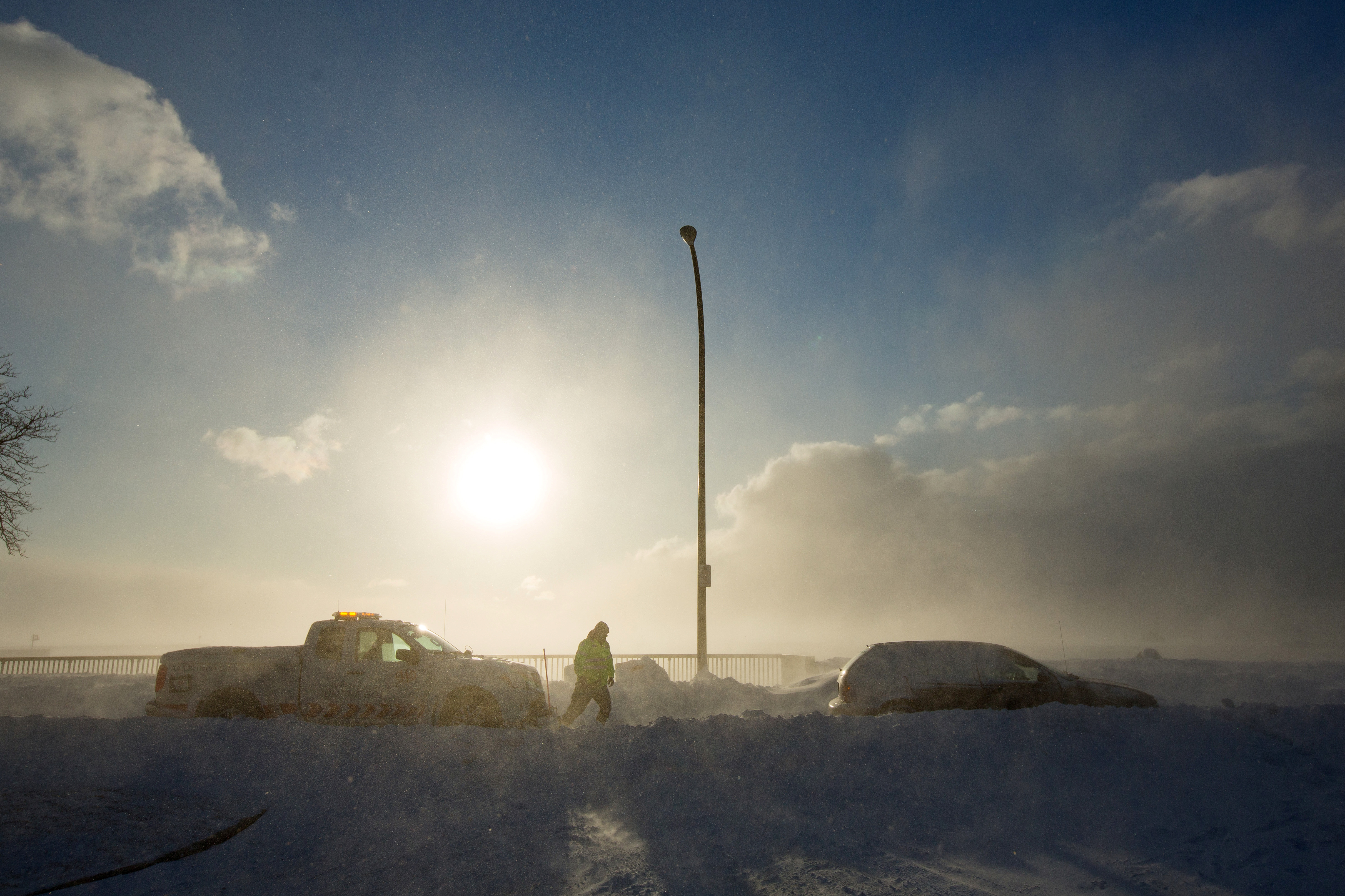
A worker from AAA aids vehicle trapped in snow during the polar vortex in Buffalo, New York, U.S., January 31, 2019. REUTERS/Lindsay DeDario

By Michael Hirtzer and Gina Cherelus

CHICAGO/NEW YORK (Reuters) – Frigid weather that paralyzed a large swath of the United States this week and caused at least 21 deaths began easing on Friday as an Arctic air mass pulled away, setting the stage for a warmer weekend in the Midwest and the Northeast.

Temperatures from southern New England to the Upper Midwest should reach the mid-40s to low 50s Fahrenheit through the weekend and Monday, forecasters said, after a record-breaking cold snap that stopped mail deliveries in some parts of the Midwest and shuttered schools and businesses.

In Chicago, which experienced temperatures as low as minus 22F (minus 30 Celsius) earlier this week, temperatures of 19F (-7C) on Friday morning felt positively balmy as a measure of normalcy returned to the nation’s third-largest city.

“It feels like summer,” said Dolores Marek, 57, as she got off her commuter train in Chicago wearing a long parka coat as set out on the 1.5 mile-(2.4 km) walk to the local college where she works. “This is much better than it was.”

Meteorologists linked the spell of brutal cold to the so-called polar vortex, a cap of icy air that usually swirls over the North Pole. Changing air currents caused it to slip down through Canada and into the U.S. Midwest this week.

Bryan Jackson, a National Weather Service meteorologist, said the core of the vortex was pulling north into eastern Canada, though residual icy air was still pushing over to the U.S. Northeast.

Temperatures on Friday morning ranged from below zero Fahrenheit to the teens in parts of New York, Pennsylvania, Massachusetts and New Jersey. The Washington D.C. area, which had 20F (minus 7C) temperatures, was under a winter weather advisory until the afternoon as around one inch (2.5 cm) of snowfall accumulated during the morning.

“That cold air that was over the Great Lakes, over the Midwest, has shifted off. Now the high pressure is over Pennsylvania and New York,” Jackson said in a phone interview. “As it moves east, it’ll bring in air from the south and we do expect it to warm up over the weekend.”

Rachel Liao, 29, a student at the New School in New York, said she wished classes had been canceled due to the cold.

A woman takes a selfie in front of a mostly frozen Bryant Park fountain, as record low temperatures spread across the Midwest and Eastern states, in New York City, U.S., January 31, 2019. REUTERS/Brendan McDermid

A woman takes a selfie in front of a mostly frozen Bryant Park fountain, as record low temperatures spread across the Midwest and Eastern states, in New York City, U.S., January 31, 2019. REUTERS/Brendan McDermid

“I just want to stay inside,” Liao, a New York native, said. “I’m not used to this.”

Temperatures in the Upper Midwest, including Illinois, Indiana and Ohio, will reach well above zero F (minus 18C) on Friday, with highs making it into the teens and low 20s.

Even so, parts of Minnesota, Wisconsin, Michigan and Iowa were still experiencing temperatures in the negative single digits, Jackson said.

The lowest temperature recorded early Friday morning was minus 34F (minus 37C) in Stonington, Michigan, according to the National Weather Service.

By Saturday, highs will be in the 30s and even low 40s in the Midwest. The central Plains will be in the low 60s, nearly 20 to 25 degrees above normal, the weather service said.

More than 40 cold-temperature records were broken on Thursday, the coldest morning since the polar vortex moved in late on Tuesday. The mass of Arctic air had clung to a swath of the United States from Iowa and the Dakotas across the Great Lakes region and into Maine for days.

Officials across multiple states linked at least 20 deaths to the deep freeze. The death toll rose after at least nine more people in Chicago were reported to have died from cold-related injuries, according to Stathis Poulakidas, a doctor at the city’s John H. Stroger Jr. Hospital.

Amtrak train services that had been halted since Wednesday in Chicago’s hub resumed on Friday, as did U.S. postal service that was halted or limited in six Midwest states.

Thousands of flights were canceled and delayed earlier in the week, mostly out of Chicago, but on Friday the flight-tracking site FlightAware reported cancellations in the United States down to more than 400.

(Reporting by Rich McKay in Atlanta and Gina Cherelus in New York; Additional reporting by Peter Szekely and Gabriella Borter in New York and Michael Hirtzer in Chicago; Editing by Larry King, Jonathan Oatis and Frances Kerry)

Record-breaking cold clobbers two-thirds of the U.S.

FILE PHOTO: Cars move along a snow-covered road in Denver, U.S., January 22, 2019 in this video grab obtained from social media video by Reuters January 28, 2019. Denver International Airport/via REUTERS

By Rich McKay

(Reuters) – Two-thirds of the continental United States will be a frozen ice box Tuesday, as the so-called polar vortex of frigid arctic air spins across the U.S. Midwest, clips the Great Lakes, the Ohio Valley and pushes on into New England.

And the sub-zero cold and bitter winds will stick around for a couple of days, possibly bringing dozens of record lows with a life-threatening freeze before dissipating by the weekend, the National Weather Service reported (NWS).

The polar vortex is a mass of freezing air that normally spins around the North Pole, but has slipped southward and swirled into the United States, forecasters said.

The hardest-hit area will be the Midwest, where wind chill could bring temperatures as low as -50 F (-46C) in the Chicago area by Tuesday evening, the NWS reported. One-to-two feet of snow was forecast in Wisconsin, and six inches in Illinois.

Even Alabama and Mississippi could see snow, the service added.

“This arctic air dumps out of Canada and will affect us for days,” said Richard Bann, a forecaster with the NWS’s Weather Prediction Center in College Park Maryland.

“We’ll even get some snow this afternoon in the (Washington) D.C. area,” he said. “And because it’s so cold, there won’t be much of a warm-up Wednesday. You’ll have to wait for the weekend, before you see any higher temperatures.”

Blizzard conditions were predicted across parts of the western Ohio Valley and snow was expected through Wednesday from the Great Lakes region into New England.

States of emergency have been declared from Wisconsin and Michigan, down to Alabama and Mississippi.

In Illinois, Governor J.B. Pritzker said wind chill could drive temperatures to -55 degrees Fahrenheit in northern parts of the state on Tuesday evening, a level that can cause frostbite in a matter of minutes.

“This is a potentially historic winter storm that will bring extreme cold to our state and all Illinoisans must prepare,” Pritzker said in a written statement released by his office.

Parts of north and central Georgia are expecting about 2 inches of snow or more in the coming days, along with freezing rain and ice-slicked highways. Georgia Gov. Brian Kemp shut down government offices in 35 counties Tuesday, and schools across swaths of the state are also closed.

Air traffic in the region is affected, with more than 1,200 flights canceled and as many delayed, the flight tracking site FlightAware.com reported early Tuesday.

Atlanta-based Delta Air Lines Inc said it would waive flight change fees for passengers affected by the winter weather in Chicago, Detroit and areas of the Upper Midwest.

(Reporting by Rich McKay in Atlanta, Maria Caspani and Gina Cherelus in New York and Dan Whitcomb in Los Angeles; Editing by Andrew Heavens)

Polar Vortex Drives Down Summer Temperatures

The polar vortex is back…but many Americans are happy to see it arrive this time.

The vortex is bringing cool summer temperatures into the Midwest and south that remind many residents of early September rather than the middle of June.  In some areas, record low temperatures are being set and the daily highs are the lowest in history.

Mobile, Alabama, on the Gulf of Mexico, reported a low temperature of 64 degrees Thursday morning, breaking a 128-year-old temperature record.  Huntsville, Alabama tied a record low of 59 degrees set in 1945.

Nashville, Tennessee tied a record set in 1886 of 57 degrees.  Other cities setting temperature low records included Kansas City, Missouri and Omaha, Nebraska.

Forecasters say the cool air from the vortex is going to expand eastward through the rest of the week and into the weekend, bringing down temperatures from Michigan to southern Louisiana.

The temperature shifts have also caused unusual weather incidents.  Waterspouts formed over Lake Erie on Sunday and meteorologists say the other Great Lakes are at risk for waterspouts because of warmer waters mixing with colder air.

Bitter Cold Freezes Niagara Falls

While not completely frozen to the riverbed, Niagara Falls is putting on a display of winter beauty from the latest polar vortex.

The upper part of the waterfall has completely frozen in the bitter temperatures, creating the impression for the second time this winter that the legendary waterfall has completely frozen.

The water pressure keeps the falls from freezing to the riverbed meaning that under the stacks of ice the river continues to rage.  However, none of the running water can be seen flowing over the falls as sheets of ice blanket the rocks and hills surrounding the falls.

Temperatures in the area have been hovering between zero and 9 degrees this week.

The cold freezing the falls is not the only record cold.  In Iowa, Des Moines broke a low temperature record set in 1884.  Atlantic City set a record not only for March 3rd but also for the entire month of March with 2 above zero, breaking a record dating back to 1874.  Several towns around Washington DC also shattered records.

Potentially Record Cold Facing Midwest

Forecasters say that a temperature record that was set in the 19th century for Chicago could be in danger over the next week.

The polar vortex bringing cold temperatures back to the Midwest and Upper Plains states could cause Chicago to see a high temperature for Wednesday stay below the record for the date of 10 degrees set in 1888.   The standing low record for the date is 1 below zero, but that was not broken overnight.  It could still be broken later tonight.

Wind chill is also a major problem in the city with some areas reporting a wind chill more than 20 below zero.

The problem is predicted to be compounded by a second wave of cold air from the arctic that will force temperatures as far as ten below zero with wind chills greater than 30 below zero.

Forecasters say it’s possible the record low maximum temperature for Thursday, also 10 degrees set in 1888, could fall because of the second blast of cold air.  The record low on February 28th of zero degrees set in 1884 is also likely to fall.

The blast of cold air is expected to keep driving down temperatures for over a week.

Polar Vortex Isn’t Done Yet

If you packed away your winter coat, dig it back out.

Meteorologists say the polar vortex, which has wreaked so much havoc on temperatures and winter storms, is coming back for at least one more round before the winter is over.

The National Weather Service reports that record cold temperatures are possible for the Upper Midwest, Great Lakes and High Plains areas of the country.  Minneapolis, Chicago, Buffalo and other northern cities could face temperatures as much as 40 degrees lower than normal this week.

The Climate Prediction Center says the frigid temperatures could last through the first week of March.

Third Polar Vortex Likely Coldest

A third “polar vortex” is aiming at the U.S. this week and it could bring the lowest temperatures of this winter’s trio of storms.

The forecast models show the frigid arctic air reaching into northern Mexico and all the way to south-central Florida.  Parts of the Gulf of Mexico could see temperatures well below freezing.

The vortex is also expected to be longer than the previous two, lasting almost three days in some regions.  Cities in the upper to central Midwest could be facing lows below zero for consecutive days with wind chills that could reach -50 degrees.

The National Weather Service said it could actually be warmer in the nation’s northernmost city, Barrow, Alaska, than it could be in most of the Midwest.  Barrow’s predicted high for Monday is -4 degrees.  That is the same predicted high for Chicago.

Forecasters say the temperature without wind chill could reach -17 degrees downtown.  Wind chills could surge past -40 degrees.

In the northern Midwest, residents faced an additional problem as high winds blew snow to the point it made travel impossible.

Officials across the Midwest are encouraging residents to stay inside for the next two days and avoid travel unless absolutely necessary.

Southern Canada Hit By Weather-Created “Frost Quakes”

Canadians are experiencing a rare phenomenon as part of the polar vortex that has descended over the central part of North America.

Meteorologists call the incidents “frost quakes” and they can produce a sound as strong as a sonic boom.

The “quakes” happen when ice and rain seep into the ground and then the temperature falls so low that it freezes, causing the earth to split open as during an earthquake.

The phenomenon shocked residents of Toronto who thought someone was breaking into their homes or that gunfire had erupted in their neighborhoods. Toronto police reported hundreds of calls from worried residents over loud, unexplained noises.

Some residents told London’s Daily Mail that the quakes were strong enough to wake them from sleep and make dishes rattle.