Tropical Storm Gordon hits southern Florida, spins toward U.S. Gulf Coast

FILE PHOTO: Homes sit on the edge of the Gulf of Mexico in the Myrtle Grove Estates development in Plaquemines Parish, Louisiana, U.S. October 7, 2017. REUTERS/Jessica Resnick-Ault/File Photo

By Jon Herskovitz and Rich McKay

(Reuters) – A tropical storm whipped the southern tip of Florida with high winds and rain on Monday morning and was forecast to gain strength as it passed over the Gulf of Mexico toward Louisiana, officials said.

Tropical Storm Gordon was forecast to drop as much as 8 inches (20 cm) of rain in some areas of the U.S. South still reeling from hurricanes a year ago.

The storm was generating winds of 45 miles per hour (72 km/h) on Monday as it steamed west-northwest at 17 miles an hour (27 km/h), National Hurricane Center Director Kenneth Graham said in a video briefing on Facebook.

“It looks like for the next three or four days we’re going to be having to really watch close,” Graham said, “and remember if you’re even inland you can get some of these heavy rainfall totals so now is the time to be prepared.”

Last year, hurricanes walloped Texas, Florida and Puerto Rico, causing thousands of deaths, hundreds of billions of dollars in damage, massive power outages and devastation to hundreds of thousands of structures.

The National Hurricane Center warned of high winds around parts of Florida as the storm passed over the southern tip of the state on Monday morning.

The storm was expected to strengthen over the Gulf of Mexico, and reach the central Gulf Coast states of Alabama, Mississippi and Louisiana late on Tuesday, the National Hurricane Center said.

At the mouth of the Mississippi River, around the area of New Orleans, the storm could generate a surge of up to 4 feet (1 meter) and smaller surges could hit coastland along other parts of the Gulf Coast, Graham said.

“The combination of a dangerous storm surge and the tide will cause normally dry areas near the coast to be flooded by rising waters moving inland from the shoreline,” the National Hurricane Center said in a statement.

Louisiana Governor John Bel Edwards said on Sunday he had activated the state’s Crisis Action Team as a precaution.

There were no immediate indications that the storm had affected energy operations in the Gulf of Mexico area.

(Reporting by Rich McKay in Atlanta, Alex Dobuzinskis in Los Angeles; Editing by Frank McGurty and Andrea Ricci)

Hurricane Lane strengthens to Category 5 as it heads for Hawaii

Members of the Alapahoe outrigger canoe club move their canoes off the beach to higher ground as Hurricane Lane approaches Honolulu, Hawaii, U.S. August 21, 2018. REUTERS/Hugh Gentry

By Jolyn Rosa

HONOLULU (Reuters) – Hurricane Lane strengthened to a Category 5 storm on Tuesday as it charged toward Hawaii where residents braced for “life threatening” winds and flooding, the National Hurricane Center (NHC) said.

Forecasters said it was still uncertain whether the eye of the powerful hurricane would hit land in the U.S. island chain, whose Big Island is reeling from a three-month eruption of Kilauea volcano.

But “preparations to protect life and property should be rushed to completion,” the center said.

The center of the storm is expected to track “dangerously” close to or over the islands Thursday through Saturday, the NHC said.

Jaycee Sotello fills her truck up with gas as Hurricane Lane approaches Honolulu, Hawaii, U.S. August 21, 2018. REUTERS/Hugh Gentry

Jaycee Sotello fills her truck up with gas as Hurricane Lane approaches Honolulu, Hawaii, U.S. August 21, 2018. REUTERS/Hugh Gentry

A direct hit anywhere in Hawaii “would be a worst-case scenario,” said Thomas Birchard, a meteorologist with the hurricane center.

The powerful hurricane was about 350 miles (565 km) south-southeast of Kailua-Kona, Hawaii, with maximum sustained winds of 160 miles per hour (260 km/h) at about 11:30 p.m. local time, the NHC said.

As of late Tuesday night, a hurricane warning was in effect for the Big Island and a hurricane watch was in effect for the rest of the state, the hurricane center said.

The storm, which was moving west-northwest near 9 mph (15 km/h), was expected to turn toward the northwest on Wednesday, followed by a turn to the north-northwest on Thursday, the center said.

Winds and rain from the storm are expected to hit the Big Island, then churn north over the islands of Maui, Lanai, and Moloka’i, which were all under hurricane and flash flood watches.

Rainfall of 20 inches (51 cm) in some areas could lead to major flash flooding, landslides, and mudslides, the NHC said.

Devastation caused by winds and flooding may make locations uninhabitable for weeks and Hawaii residents to be prepared to evacuate their homes, local authorities warned.

(Reporting by Andrew Hay and Brendan O’Brien; Editing by Bill Tarrant, Sandra Maler, and Andrew Heavens)

Officials urge patience as Florida towns re-open after Irma

Officials urge patience as Florida towns re-open after Irma

By Andy Sullivan and Robin Respaut

FLORIDA CITY/MARCO ISLAND, Fla. (Reuters) – Florida began allowing some residents to return to their homes hammered by Hurricane Irma on Tuesday, but officials warned that it would take a long time to repair the damage wrought by high winds and pounding surf, particularly in the Keys archipelago.

Irma, which had rampaged through the Caribbean as one of the most powerful Atlantic hurricanes on record, was downgraded to a tropical depression on Monday. It will likely dissipate from Tuesday evening, the National Hurricane Center said.

At its peak it prompted the evacuation of 6.5 million people, the largest evacuation in modern U.S. history.

Local authorities told around 90,000 residents of Miami Beach and from some parts of the Florida Keys they could go home but warned it may be prudent not to remain there.

“This is going to be a frustrating event. It’s going to take some time to let people back into their homes particularly in the Florida Keys,” Brock Long, administrator of the Federal Emergency Management Agency, told a morning press conference.

He noted that FEMA was continuing to rescue people stranded by flooding around Jacksonville, in the state’s northeast.

After leaving a trail of destruction on several Caribbean islands, killing nearly 40 people, Irma caused record flooding in parts of Florida. Only one Florida fatality has been confirmed so far, but a local official said there had been more deaths.

Irma became the second major hurricane to make landfall in the United States in a little more than two weeks when it roared ashore on Key Cudjoe as a powerful Category 4 storm on Sunday. It followed Hurricane Harvey, which plowed into Houston late last month, killing about 60 and wreaking some $180 billion in damage, largely through flooding.

About 2-1/2 months remain in the official Atlantic hurricane season. The National Hurricane Center is monitoring another hurricane, Jose, which is spinning in the Caribbean, currently about 700 miles (1,130 km) from the mainland.

MILITARY AID

The U.S. aircraft carrier Abraham Lincoln has arrived off Florida’s east coast and two amphibious assault ships will arrive on Tuesday to help in the Keys. The military will distribute food and help evacuate 10,000 residents who did not leave before the storm.

Monroe County Commissioner Heather Carruthers said Monday that people had been killed in the Keys, where nearly 80,000 permanent residents live, apart from one already known fatality. She did not have a count on how many.

“We are finding some remains,” she said in an interview with CNN. Video footage of the islands showed homes torn apart by sustained winds of up to 130 mph (210 kph).

Several major airports in Florida that halted passenger operations due to Irma began limited service on Tuesday, including Miami International, one of the busiest U.S. airports.

The scope of damage in Florida and neighboring states paled in comparison with the devastation left by Irma in parts of the Caribbean, where it razed islands and killed nearly 40.

RECORD FLOODS

The center of Irma moved into Alabama on Tuesday and will head into western Tennessee by Tuesday evening with maximum sustained winds of 25 mph.

In South Carolina, the Charleston Harbor area saw major flooding on Monday with water about 3 feet (1 meter) above flood stage and minor flooding is forecast for Tuesday, the National Weather Service said.

Miami Beach will allow residents to return home from 8 a.m. (1200 GMT), its mayor said. More evacuation orders are likely to be lifted on Tuesday.

Monroe County opened road access on Tuesday morning for residents and business owners from Key Largo, the main island at the upper end of the chain, as well as the towns of Tavernier and Islamorada farther to the south, fire officials said.

No timetable was given for reopening the remainder of the Keys.

MOST OF FLORIDA WITHOUT ELECTRICITY

Insured property losses in Florida from Irma are expected to run from $20 billion to $40 billion, catastrophe modeling firm AIR Worldwide estimated.

Utilities reported some 7.4 million homes and businesses were without electricity in Florida and neighboring states and said it could take weeks to fully restore service.

Between 2,000 and 3,000 utility workers from out of state, sent to inspect and repair power lines, were staying in Broward County in cramped conditions at BB&T Center, home to the National Hockey League’s Florida Panthers, said Gus Beyersdorf, 40, of De Pere, Wisconsin.

“Each one of us has a cot, a single foot apart,” Beyersdorf said on Monday afternoon. “I slept in the truck last night just to get a break from it.”

At least one other possibly storm-related fatal car crash was reported on Sunday in Orange County, Florida. On Monday, two people were killed by falling trees in two Atlanta suburbs, according to local authorities.

(Additional reporting by Daniel Trotta in Orlando, Fla., Bernie Woodall, Ben Gruber and Zachary Fagenson in Miami, Dan Whitcomb in Los Angeles, Letitia Stein in Detroit, Jon Herskovitz in Austin, Texas, Colleen Jenkins in Winston-Salem, N.C., Harriet McLeod in Mt. Pleasant, S.C., Scott DiSavino in New York and Marc Frank in Havana; Writing by Scott Malone and Jon Herskovitz; Editing by Raissa Kasolowsky and Chizu Nomiyama)

Residents flee Texas coast ahead of Hurricane Harvey landfall

By Brian Thevenot

CORPUS CHRISTI, Texas (Reuters) – Businesses closed and lines of cars streamed out of coastal Texas as officials called for residents to evacuate ahead of Hurricane Harvey, expected to arrive about midnight as the most powerful storm to hit the U.S. mainland in more than a decade.

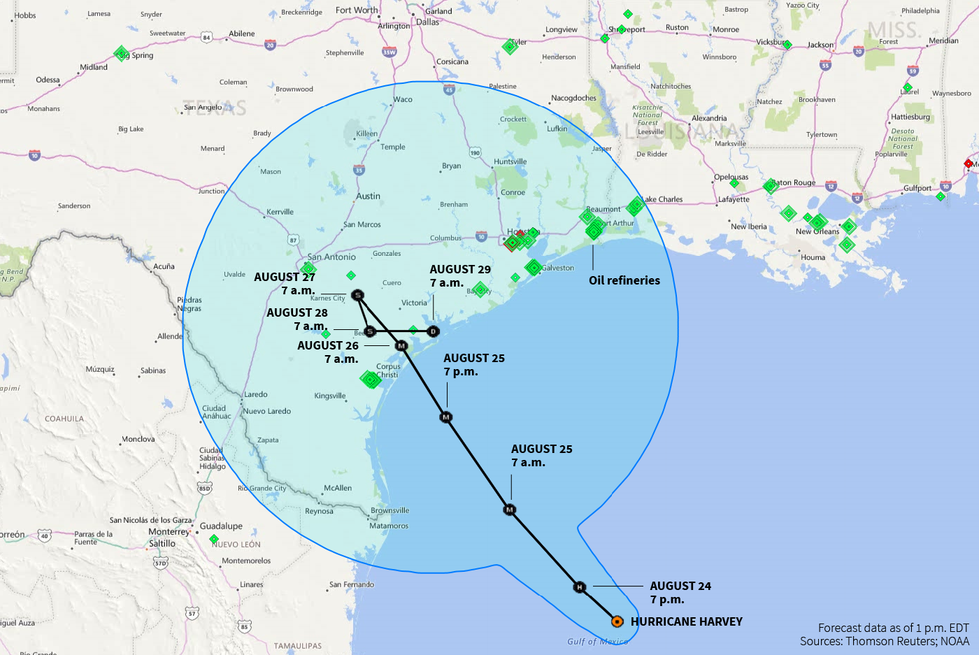
The hurricane is forecast to slam first near Corpus Christi, Texas, drop flooding rains along the central Texas coast and potentially loop back over the Gulf of Mexico before hitting Houston, some tracking models showed.

“My urgent message to my fellow Texans is that if you live in a region where evacuation has been ordered, you need to heed that advice and get out of harm’s way while you can,” Texas Gov. Greg Abbott said in a televised address.

The storm has so far shutdown 22 percent, or 377,000 barrels per day (bpd) of Gulf of Mexico oil production, the U.S. reported Friday afternoon, and halted 4.4 percent of U.S. refinery output. Some inland shale oil producers ceased operations as a precaution against expected flooding.

Gas stations and grocery stores in the region were packed as residents readied their cars and pantries for any shortages following the storm. Coldplay, the British rock band, canceled a Friday concert in Houston, telling fans it didn’t want to risk anyone’s safety.

At a Willis, Texas, station, about 50 miles (77 km) north of Houston, Corey Martinez, 40, was heading to Dallas from his Corpus Christi home.

“It has been pretty stressful. We’re just trying to get ahead of the storm,” he said. “We’ve never been through a hurricane before.”

Harvey became a Category 3 hurricane on Friday, the National Hurricane Center said, the third most powerful on the Saffir-Simpson scale with winds of 111-129 mile per hour (178-208 km/h) that can uproot trees, damage homes and disrupt utilities for days. That would make it the first major hurricane to hit the mainland United States since Hurricane Wilma struck Florida in 2005.

The storm was about 85 miles (140 km) off Corpus Christi and packing winds of 110 mph in early afternoon on Friday, the NHC said. It projected windspeeds could reach 120 mph just before landfall.

The NHC’s latest tracking model shows the storm sitting southwest of Houston for more than a day, giving the nation’s fourth most populous city a double dose of rain and wind.

“Now is the time to urgently hide from the wind. Failure to adequately shelter may result in serious injury, loss of life, or immense human suffering,” the National Weather Service said.

Up to 35 inches (97 cm) of rain are expected over parts of Texas, and sea levels may surge as high as 12 feet (3.7 meters). Louisiana could get 10 to 15 inches of rain. Flood warnings are in effect for Louisiana and northern Mexico.

“Life-threatening and devastating flooding expected near the coast due to heavy rainfall and storm surge,” the NHC said.

The storm’s approach triggered evacuations in south Texas communities and central coast residents were voluntarily leaving the area. Cities canceled classes on Friday and Monday at dozens of schools along the south Texas coast, home to 5.8 million people from Corpus Christi to Galveston.

David Ramirez left his home in Corpus Christi early on Friday to wait out the storm in San Antonio, Texas.

“With the level of storm surge they’re talking about, there isn’t a lot I could do to protect my house,” he said in an interview while awaiting directions to an emergency shelter.

Harvey also forced the cancellation or delay of at least 40 flights in and out of major airports in Texas on Friday, according to Flightaware.com, which tracks airline traffic.

Louisiana and Texas declared states of disaster, authorizing the use of state resources to prepare. President Donald Trump has been briefed and is ready to provide resources if needed, the White House said on Thursday.

The port of Houston, the nation’s busiest petrochemical port, closed its terminals at noon, and earlier halted inbound and outbound ship traffic on Friday. The city of Houston warned residents of flooding from close to 20 inches of rain over several days.

GASOLINE PRICES SPIKE

More than 45 percent of the country’s refining capacity is along the U.S. Gulf Coast, and nearly a fifth of the nation’s crude oil is produced offshore. Ports from Corpus Christi to Texas City, Texas, were closed to incoming vessels.

The U.S. government said 9.6 percent of crude output capacity was shut and 14.6 percent of natural gas production was halted.

Three refineries in Corpus Christi and one farther inland at Three Rivers were shutting down ahead of the storm. Two others reduced output as ports were closed.

Concern that Harvey could cause shortages in fuel supply drove benchmark gasoline prices to their highest in four months, before profit trading pulled back prices. Meanwhile, U.S. gasoline margins hit their strongest levels in 5 years for this time of year earlier in the day.

Prices for gasoline in spot physical markets on the Gulf Coast rose to a near three-year high.

The U.S. government has emergency stockpiles of crude available to plug disruptions, and has regularly used them to dampen the impact on energy supplies of previous storms.

The stockpiles in the Strategic Petroleum Reserve were last used in 2012, after Tropical Storm Isaac shut down 95 percent of oil output in the Gulf and hit Louisiana. The government has not yet said if it plans to use the reserve after Harvey.

Houston-based energy bank Tudor Pickering Holt & Co said in a note not to expect significant or lasting production impacts from Harvey. But it said it would impact some production and disrupt refinery runs, imports and exports, “which will show up in the weekly inventory numbers for the next few weeks.”

Royal Dutch Shell Plc, Anadarko Petroleum Corp and Exxon Mobil Corp have evacuated staff from offshore oil and gas platforms in the storm’s path.

The potential for flooding at shale oil fields in south Texas that produce more than one million barrels of oil a day led several producers to curb operations. EOG Resources Inc said shut some production in the Eagle Ford shale region. Noble Energy Inc and Statoil ASA also said they were evacuating some staff from production facilities.

Union Pacific Corp, the No. 1 U.S. railroad, said it was moving rail cars in yards prone to flooding to high elevations and will curtail trains operating through areas likely to be hit by excessive winds and rain that will impact operations.

Union Pacific said changes could include locations from Brownsville near the border with Mexico north to Beaumont, Texas.

(Reporting by Brendan O’Brien in Milwaukee and Brian Thevenot in Corpus Christi; Editing Meredith Mazzilli and Andrew Hay)

Hurricane Harvey strengthens, threatens U.S. with most powerful storm in 12 years

Hurricane Harvey strengthens, threatens U.S. with most powerful storm in 12 years

GALVESTON, Texas (Reuters) – Hurricane Harvey intensified early on Friday into potentially the biggest hurricane to hit the U.S. mainland in more than a decade, as authorities warned locals to shelter from what could be life-threatening winds and floods.

Harvey is set to make landfall late Friday or early Saturday on the central Texas coast where Corpus Christi and Houston are home to some of the biggest U.S. refineries. Oil and gas operations have already been affected and gasoline prices have spiked.

“Now is the time to urgently hide from the wind. Failure to adequately shelter may result in serious injury, loss of life, or immense human suffering,” the National Weather Service said.

Harvey grew into a category 2 storm with winds of 105 mph (169 kph) as it moved northwest about 185 miles (295 km) off Port O’Connor, Texas, the National Hurricane Center said.

Up to 35 inches (97 cm) of rain are expected over parts of Texas, with winds up to 125 mph, and sea levels may surge as high as 12 feet (3.7 meters). Louisiana could get 10 to 15 inches of rain. Flood warnings are in effect for Louisiana and northern Mexico.

“Life-threatening and devastating flooding expected near the coast due to heavy rainfall and storm surge,” the hurricane center said.

The storm’s approach triggered evacuations and forced the cancellation of classes on Friday at dozens of schools along the south Texas coast, home to 5.8 million people from Corpus Christi to Galveston.

It also forced the cancellation or delay of at least 40 flights in and out of major airports in Texas on Friday, according to Flightaware.com, a site that tracks airline traffic.

Louisiana and Texas declared states of disaster, authorizing the use of state resources to prepare for the storm. President Donald Trump has been briefed and is ready to provide resources if needed, the White House said on Thursday.

Harvey is forecast to come ashore as a Category 3 hurricane, the National Hurricane Center said, the third most powerful on the Saffir-Simpson scale. That would make it the first major hurricane to hit the mainland United States since Hurricane Wilma struck Florida in 2005.

The NHC expects Harvey to move slowly over Texas and linger over the state for days. Houston, the nation’s fourth most populous city, warned residents of flooding from close to 20 inches of rain over several days.

GASOLINE PRICES SPIKE

More than 45 percent of the country’s refining capacity is along the Gulf Coast, and nearly a fifth of the nation’s crude oil is produced offshore. Ports from Corpus Christi to Texas City, Texas, were closed to incoming vessels.

The government said 9.6 percent of crude output capacity was shut and 14.6 percent of natural gas production was halted.

Three refineries in Corpus Christi and one farther inland at Three Rivers were shutting down ahead of the storm. Concern that Harvey could cause shortages in fuel supply drove benchmark gasoline prices to a three-week high.

One other refinery reduced output and others were considering shutting.

Prices for gasoline in spot physical markets on the Gulf Coast rose even more, hitting a one-year high.

Profit margins for refineries producing gasoline rose by more than 12 percent on Thursday, on course for their biggest daily percentage gain in six months, according to Reuters data.

Royal Dutch Shell Plc, Anadarko Petroleum Corp and Exxon Mobil Corp have evacuated staff from offshore oil and gas platforms in the storm’s path.

The storm could also bring flooding to shale oil fields in southern Texas that produce more than one million barrels of oil a day.

EOG Resources Inc said it had curtailed drilling and shut some production in the Eagle Ford shale region. Noble Energy Inc and Statoil ASA also said they were evacuating some staff from production facilities.

(Reporting by Brendan O’Brien in Milwaukee; Editing by Robin Pomeroy)

U.S. gasoline prices rise, refineries shut as Texas braces for hurricane

Tropical Storm Harvey is seen approaching the Texas Gulf Coast,. NOAA/via Reuters

By Jim Forsyth

SAN ANTONIO (Reuters) – U.S. gasoline prices surged to a three-week high on Thursday as Hurricane Harvey moved across the Gulf of Mexico and threatened to slam oil refineries in Texas when it comes ashore this weekend.

The U.S. National Hurricane Center (NHC) upgraded Harvey to a hurricane from a tropical storm on Thursday afternoon, and said it would strengthen into a Category 3 hurricane before hitting the Texas coast late on Friday or early on Saturday.

The storm is now expected hit the central Texas coast with a combination of winds of 115 miles (185 km) per hour and heavy rains, said John Tharp, a forecaster with Weather Decision Technologies in Norman, Oklahoma.

“With this system’s intensity and slow motion, it is the worst of both worlds,” he said referring to the expected winds and rains. “There will be major impacts along the coast and inland with periods of prolonged rain.”

Harvey will cause a storm surge that will flood parts of the Texas coast as it makes landfall and linger for days over the state, dumping up to 30 inches (76.2 cm) of rain on some areas, the NHC said in an advisory on Thursday.

The mayor of Texas coastal city Corpus Christi warned on Wednesday that flooding was his biggest concern.

“I hope people will listen to forecasters when they say ‘beware of flash floods,'” Joe McComb said. “Flash floods can come quickly, and they can be deadly.”

The city, a major oil refining center, has not issued any evacuation orders, he told reporters at a news conference, but its emergency operations center has been activated.

Harvey has already disrupted U.S. oil supplies.

Energy companies including Royal Dutch Shell <RDSa.L>, Anadarko Petroleum <APC.N> and Exxon Mobil <XOM.N> have evacuated staff from offshore oil and gas platforms in the storm’s path.

Two oil refineries Corpus Christi were shutting down ahead of the storm, and concern that Harvey could cause shortages in fuel supply drove benchmark gasoline prices <RBc1> to a three-week high.

Prices for gasoline in spot physical markets on the Gulf Coast rose even more, hitting a one-year high.

Profit margins for refineries producing gasoline rose by over 12 percent on Thursday, putting margins on course for their biggest daily percentage gain in six months, according to Reuters data.

The two refineries that have shut have combined capacity to refine more than 450,000 barrels per day of crude.

The NHC expects the storm to come ashore along the central Texas coast, an area that includes Corpus Christi and Houston, home to some of the biggest refineries in the country.

More than 45 percent of the country’s refining capacity is along the U.S. Gulf Coast, and nearly a fifth of the nation’s crude oil is produced offshore in the region.

The storm could also bring flooding to inland shale oil fields in Texas that pump millions of barrels per day of crude.

Texas Governor Greg Abbott declared a state of disaster on Wednesday for 30 counties, authorizing the use of state resources to prepare for the storm.

Coastal cities and counties distributed sandbags to residents as some businesses boarded up windows, and residents flocked to grocery stores to stock up on supplies, local media reported.

Texas A&M University-Corpus Christi issued a mandatory evacuation to all students who live on campus and canceled events.


(Additional reporting by Jarrett Renshaw and Devika Krishna Kumar in NEW YORK, Erwin Seba and Ernest Scheyder in HOUSTON, Brendan O’Brien in Milwaukee; Writing by Simon Webb; Editing by Meredith Mazzilli)


NHC says Harvey quickly strengthening, to be a major hurricane

Tropical Storm Harvey is seen approaching the Texas Gulf Coast,. NOAA/via Reuters

(Reuters) – Tropical storm Harvey is gaining strength and is expected to be a major hurricane when it approaches the middle Texas coast, the U.S. National Hurricane Center said in its latest update on Thursday.

“Harvey will approach the middle Texas coast on Friday and make landfall Friday night or early Saturday, and then stall near the middle Texas coast through the weekend,” the NHC said.

The system is located 365 miles (590 kilometers) southeast of Corpus Christi, Texas, and packing maximum sustained winds of 65 miles per hour (100 km/h), the Miami-based weather forecaster said.

(Reporting by Karen Rodrigues and Eileen Soreng in Bengaluru)

Weakening Typhoon Noru makes landfall, batters central Japan with rain

A big wave caused by Typhoon Noru crashes on a breakwater in Aki, Kochi Prefecture, Japan in this photo taken by Kyodo on August 7, 2017.

By Elaine Lies

TOKYO (Reuters) – A weakening Typhoon Noru made landfall in central Japan on Monday, pounding some regions with more than a month’s worth of rain, but while it appeared likely to brush close to Tokyo it was losing much of its strength.

At one point the world’s strongest storm this year, Noru’s approach to the Japanese heartland prompted evacuation advisories for tens of thousands on Shikoku, Japan’s smallest main island, and more than 400 flights were canceled, NHK public broadcaster said.

But there were no further deaths reported than two at the weekend, one of them a fisherman in his 80s who went out to check on his boat during the storm. No people were missing and only around a dozen injured, NHK added.

Noru, whose name is the Korean word for a type of deer, made landfall in the central prefecture of Wakayama on Wednesday afternoon and continued to head northeast, raising the possibility it could brush past Tokyo on Tuesday – although by then it will have weakened to a tropical depression.

Parts of Shikoku were hit with 52 mm (2.1 inches) of rain in one hour on Monday morning, with some parts of central Japan likely to see 500 mm (20 inches) of rain in the 24 hours to Tuesday morning due to the storm’s unusual slowness, the meteorological agency added.

“Usually typhoons just whip right on through, but this one is so slow, the rain goes on and on,” one man told NHK.

Three Japanese oil refiners said they had halted berth oil product shipments at their refineries in western and central Japan on Monday due to a typhoon, but that there had been no impact on refining operations or truck shipments.

Noru formed more than two weeks ago and wandered around the north Pacific in a circular course until it strengthened and began heading for Japan. At one point it was a Category 5 storm, but has been downgraded to a Category 1.

Noru is likely to weaken to tropical storm strength later on Monday, according to Tropical Storm Risk.com and be a tropical depression by the time it brushes past Tokyo on Tuesday.


(Additional reporting by Osamu Tsukimori,; Editing by Michael Perry)


Tropical storm Cindy heads inland in Louisiana; one dead in Alabama

This graphic shows an approximate representation of coastal areas under a hurricane warning (red), hurricane watch (pink), tropical storm warning (blue) and tropical storm watch (yellow). The orange circle indicates the current position of the center of the tropical cyclone. The black line, when selected, and dots show the National Hurricane Center (NHC) forecast track of the center at the times indicated. The dot indicating the forecast center location will be black if the cyclone is forecast to be tropical and will be white with a black outline if the cyclone is forecast to be extratropical. Courtesy of NOAA and the National Weather Service

(Reuters) – Tropical storm Cindy was headed inland near the Louisiana-Texas border on Thursday morning and continued producing heavy rainfall and life-threatening conditions over the northern Gulf Coast, the U.S. National Hurricane Center said.

The storm caused its first reported fatality on Wednesday when a 10-year-old boy struck by a log that a large wave dislodged while he stood near shore in Fort Morgan, Alabama, the Baldwin County coroner said.

Cindy is about 30 miles (45 km) west-southwest of Lake Charles, Louisiana, with maximum sustained winds of 40 miles per hour (65 km/h), is expected to weaken into a tropical depression later on Thursday, the Miami-based weather forecaster said.

“Now is the time to hide from the wind. Remain sheltered until the hazardous wind subsides,” the National Weather Service said in an advisory early on Thursday warning.

Cindy could drop six to nine inches (15-23 cm) of rain and bring as much as 15 inches to some parts of southeastern Louisiana, Mississippi, Alabama and Florida, the NHC said.

The storm could cause a surge of up to three feet (1 meter) in isolated areas and possibly spawn tornados from southern Louisiana to the Florida Panhandle, the NHC said.

Two tornados were reported about four miles (6.4 km northwest of Biloxi, Mississippi. Two more were reported on the northwest coast of Florida, according to the National Oceanic and Atmospheric Administration.

The Louisiana Offshore Oil Port, the largest privately owned crude storage terminal in the United States, suspended vessel offloadings but expected no interruptions to deliveries from its hub in Clovelly, Louisiana.

Energy companies with operations in the Gulf of Mexico reported little impact on production. Shell suspended some well operations and Anadarko Petroleum, ENI and Enbridge said they had evacuated non-essential personnel.

The Gulf of Mexico region is home to about 17 percent of U.S. crude and 5 percent of dry natural gas output, according to the U.S. Energy Information Administration.

(Reporting by Brendan O’Brien in Milwaukee, editing by Larry King)

U.S. Gulf Coast braces for Tropical Storm Cindy

This graphic shows an approximate representation of coastal areas under a hurricane warning (red), hurricane watch (pink), tropical storm warning (blue) and tropical storm watch (yellow). The orange circle indicates the current position of the center of the tropical cyclone. The black line, when selected, and dots show the National Hurricane Center (NHC) forecast track of the center at the times indicated. The dot indicating the forecast center location will be black if the cyclone is forecast to be tropical and will be white with a black outline if the cyclone is forecast to be extratropical. Courtesy of NOAA and the National Weather Service

By Liz Hampton

(Reuters) – Communities and oil refining and production facilities from Texas to Florida braced on Tuesday for potential disruptions as Tropical Storm Cindy strengthened over the U.S. Gulf of Mexico, threatening to bring flash floods across parts of the northern Gulf Coast.

Cindy was located about 230 miles (365 km) south of Morgan City, Louisiana late Tuesday with maximum sustained winds of 60 miles (95 km) per hour, the National Hurricane Center said.

The storm was moving toward the northwest near seven miles (11 km) per hour, and this motion was expected to continue through Wednesday.

On the forecast track, the center of Cindy will approach the coast of southwest Louisiana and southeast Texas late Wednesday, and move inland over southeastern Texas on Thursday, the Miami-based weather forecaster said.

A Tropical Storm Warning is in effect for San Luis Pass, Texas to the Alabama-Florida border, Metropolitan New Orleans and Lake Pontchartrain.

“The winds aren’t looking to get much stronger than they are now,” but some areas east of Houston and toward Florida could see as much as 12 inches of rain, said Stephen Strum, vice president of extended forecast services at Weather Decision Technologies in Tulsa, Oklahoma.

“It’s moving fairly slow, so it’s going to produce rain for a long time,” he added.

Heavy rains and wind could disrupt oil supplies at the massive refining and production centers along the U.S. Gulf Coast, which could drive up prices for consumers. The Louisiana Offshore Oil Port (LOOP), the largest privately owned crude storage terminal in the United States, suspended vessel offloading operations ahead of the storm, but said it expected no interruptions to deliveries from its hub in Clovelly, Louisiana.

Royal Dutch Shell said it suspended some offshore well operations but production was so far unaffected. Anadarko Petroleum said it had evacuated non-essential staff from its Gulf of Mexico facilities.

Exxon Mobil Corp, Phillips 66, and Motiva Enterprises said the storm had not affected their refining operations.

Cindy was expected to produce six to nine inches (15-23 cm) of rain with isolated maximum amounts of 12 inches over southeastern Louisiana, southern Mississippi, southern Alabama, and the Florida Panhandle through Thursday, the NHC said.

Alabama Governor Kay Ivey declared a state of emergency. Officials in Houston, New Orleans and other cities along the Gulf Coast said they were monitoring developments. Florida Governor Rick Scott warned residents in the northwest part of his state to stay alert for flooding and heavy rain.

The storm could cause a surge of one to three feet along the coast and possibly spawn tornados from southern Louisiana to the Florida Panhandle, the NHC said.

The Gulf of Mexico is home to about 17 percent of U.S. crude output and 5 percent of dry natural gas output, according to the U.S. Energy Information Administration. More than 45 percent of the nation’s refining capacity is along the U.S. Gulf Coast, also home to 51 percent of total U.S. natural gas processing capability.

Crude oil prices for physical delivery along the U.S. Gulf Coast were relatively stable, but cash gasoline prices rose as traders expected heavy rains and possible flooding to hit refineries in the region.

Prompt U.S. Gulf Coast conventional gasoline firmed to trade as little as 2 cents per gallon under the RBOB futures contract, its strongest in four months.

WeatherBell Analytics LLC forecast 11 to 13 named tropical storms in the 2017 Atlantic Hurricane Season, according to a May outlook.

The Atlantic hurricane season runs from June 1 through Nov. 30, and has an annual average of 9.6 named storms, 5.9 hurricanes and 2.3 intense hurricanes.

Southeast of the Gulf of Mexico, a second tropical storm, Bret has been downgraded into a tropical wave.

(Reporting by Koustav Samanta, Nallur Sethuraman, Swati Verma, Apeksha Nair and Arpan Varghese in Bengaluru, Catherine Ngai and Devika Krishna Kumar in New York and Liz Hampton in Houston; Editing by Lisa Von Ahn, Chris Reese and David Gregorio)