Keep watch on the Atlantic basin as tropical activity heats up

Important Takeaways:

  • Tropical activity heats up in busy Atlantic as NHC tracks 1 storm, 3 disturbances
  • The National Hurricane Center is watching five areas in the Atlantic basin
  • The NHC is also monitoring Tropical Storm Franklin, the remnants of Tropical Storm Emily and a tropical disturbance in the Atlantic.
  • Tropical Storm Franklin is still moving slowly as it approaches the Dominican Republic. The storm is expected to bring heavy rain to both Puerto Rico and Hispaniola through the day.
  • The storm will inch towards the southern coast of Hispaniola on overnight and into Wednesday, threatening “life-threatening” flash flooding in the Dominican Republic as forecasted rain totals reach 10-15 inches in some spots, the NHC reports
  • What was Tropical Storm Emily is now just a remnant low being monitored as “Disturbance No. 2”. The disturbance does have a 30% chance of reforming into a tropical depression within in the next two days and a 50% chance within the next week.
  • The fourth area of interest in the Atlantic is near Africa. Atmospheric conditions degraded, and the NHC feels that the chances of development are low to medium that a tropical depression could form later in the week in the eastern tropical Atlantic. This disturbance has a 10% chance of development over the next two days and a 40% chance of becoming a tropical depression over the next seven days, the NHC says.

Read the original article by clicking here.

U.S. oil losses from Hurricane Ida rank among worst in 16 years

By Sabrina Valle and Arpan Varghese

HOUSTON (Reuters) -Hurricane Ida’s damage to U.S. offshore energy production makes it one of the most costly since back-to-back storms in 2005 cut output for months, according to the latest data and historical records.

Ida’s 150 mile-per-hour (240 kph) winds cut most offshore oil and gas production for more than a week and damaged platforms and onshore support facilities. About 79% of the region’s offshore oil production remains shut and 79 production platforms are unoccupied after the storm made landfall on Aug. 29.

Some 17.5 million barrels of oil have been lost to the market to date, with shutdowns expected to continue for weeks. Ida could reduce total U.S. production by as much as 30 million barrels this year, according to energy analysts.

Offshore U.S. Gulf of Mexico wells produce about 1.8 million barrels of oil per day, 16% of the daily U.S. total.

“There could be volumes that are offline for a considerable amount of time,” said Facts Global Energy (FGE) consultant Krista Kuhl. “It’s just too early to tell.”

The losses are reducing U.S. exports at a time when oil prices are trading at about $70 a barrel because of continued curbs by producing-nations group OPEC and market expectations for demand.

At least 78% of Gulf of Mexico oil and natural gas were offline on Tuesday, nine days after Ida hit the Gulf Coast, causing wind and water damages to platforms and refineries, government data showed.

Hurricanes Katrina and Rita in 2005 remain the worst hit to Gulf Coast energy facilities. The back-to-back storms caused production losses that continued for months, removing about 162 million barrels of oil over three months, FGE said.

Production in the U.S. Gulf of Mexico that year dropped 12.6%, to 1.28 million barrels per day (bpd), from the prior year, according to data for the Energy Information Administration (EIA). Total U.S. oil production fell 4.7%, EIA data showed.

Restoring output after Ida will hinge on the time needed to repair a key offshore oil and gas transfer facility. Royal Dutch Shell on Monday said it continued to assess damage to its West Delta-143 offshore platform, which transfers about 200,000 barrels of oil and gas per day from three offshore oil fields.

A group of thunderstorms in the south-central Gulf of Mexico was expected to move northeast. The storms have a 30% chance of developing into a tropical cyclone in the next two days, the National Hurricane Center said on Tuesday.

(Reporting by Sabrina Valle in Houston and Arpan Varghese in Bengaluru; Editing by Bill Berkrot and Aurora Ellis)

Ida loses punch, levees hold, but Louisiana expects more rain and flooding

By Devika Krishna Kumar

NEW ORLEANS (Reuters) -Ida lost some of its punch over southwestern Mississippi on Monday after making landfall in Louisiana as one of the most powerful hurricanes to hit the region, but it could still trigger heavy flooding, the National Hurricane Center said.

Ida, the first major hurricane to strike the United States this year, made landfall around noon on Sunday as a Category 4 storm over Port Fourchon, a hub of the Gulf’s offshore oil industry, packing sustained winds of up to 150 miles per hour (240 km per hour).

Although weakened to a tropical storm, heavy downpours could bring life-threatening flooding, the NHC said.

Federal Emergency Management Agency (FEMA) administrator Deanne Criswell said the full impact of the storm would become clear later in the day.

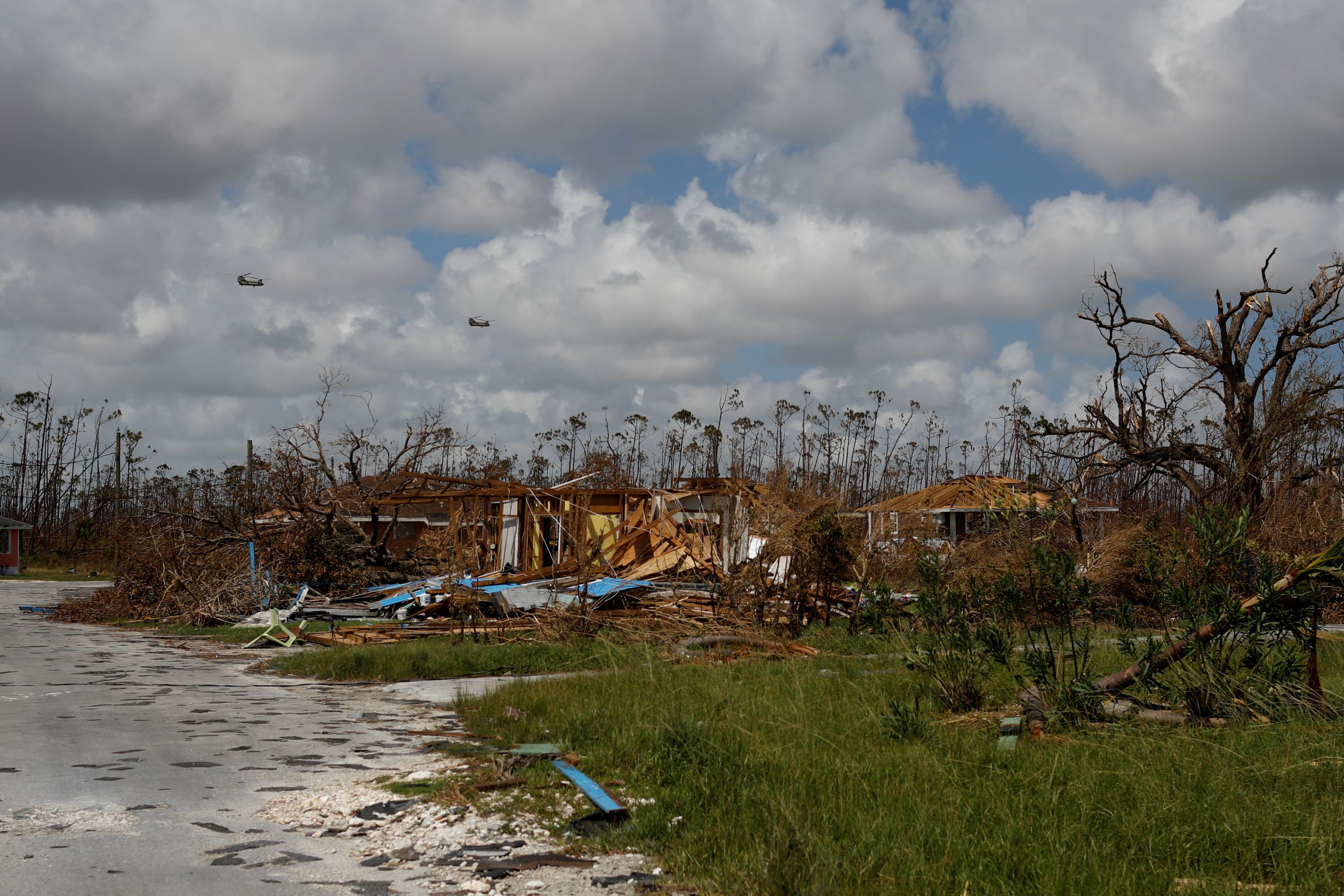
“We’re hearing about widespread structural damage,” Criswell said in an interview with CNN. “I don’t think there could have been a worse path for this storm. It’s going to have some significant impacts.”

Federal levees installed to reduce the risk of flooding appeared to have held, according to preliminary reports.

“Daylight will bring horrific images as the damage is assessed. More than 20,000 linemen will work to restore the deeply damaged power lines,” Shauna Sanford, communications director for Louisiana Governor John Bel Edwards wrote in a tweet.

“The good news: no federal levee failed or was overtopped.”

Kevin Lepine, president of Plaquemines Parish, home to 23,000 residents and one of Louisiana’s southern most communities, said he had had little sleep overnight as he braced for first light and the chance to go and assess the damage.

“We’re worried about the levees down the road,” he said.

On Sunday night, the sheriff’s office in Ascension Parish reported the first known U.S. fatality from the storm, a 60-year-old man killed by a tree falling on his home near Baton Rouge, the state capital.

President Joe Biden declared a major disaster in the state, ordering federal assistance to bolster recovery efforts in more than two dozen storm-stricken parishes.

Ida crashed ashore as Louisiana was already reeling from a resurgence of COVID-19 infections that has strained the state’s healthcare system, with an estimated 2,450 COVID-19 patients hospitalized statewide, many in intensive care units.

Its arrival came 16 years to the day after Hurricane Katrina, one of the most catastrophic and deadly U.S. storms on record, struck the Gulf Coast, and about a year after the last Category 4 hurricane, Laura, battered Louisiana.

A loss of generator power at the Thibodaux Regional Health System hospital in Lafourche Parish, southwest of New Orleans, forced medical workers to manually assist respirator patients with breathing while they were moved to another floor, the state Health Department confirmed to Reuters.

Within 12 hours of landfall, Ida had plowed a destructive path that submerged much of the state’s coastline under several feet of surf, with flash flooding reported by the National Hurricane Center across southeastern Louisiana.

Nearly all offshore Gulf oil production was suspended in advance of the storm, and major ports along the Louisiana and Mississippi coasts were closed to shipping.

WIDESPREAD OUTAGES

Power was knocked out Sunday night to the entire New Orleans metropolitan area following the failure of all eight transmission lines that deliver electricity to the city, the utility company Entergy Louisiana reported.

One transmission tower collapsed into the Mississippi River, the Jefferson Parish Emergency Management Department said.

More than 1 million Louisiana homes and businesses in all were without electricity early on Monday, as well as some 120,000 in Mississippi, according to the tracking site Poweroutage.US.

Residents of the most vulnerable coastal areas were ordered to evacuate days ahead of the storm. Those riding out the storm in their homes in New Orleans braced for the toughest test yet of major upgrades to a levee system constructed following devastating floods in 2005 from Katrina, a hurricane that claimed some 1,800 lives.

The U.S. Army Corps of Engineers said the newly reinforced New Orleans levees were expected to hold, though they said they said the flood walls could be overtopped in some places.

Hundreds of miles of new levees were built around New Orleans after flooding from Katrina inundated much of the low-lying city, especially historically Black neighborhoods.

Inundation from Ida’s storm surge – high surf driven by the hurricane’s winds – was reported to be exceeding predicted levels of 6 feet (1.8 m) along parts of the coast. Videos posted on social media showed storm surge flooding had transformed sections of Highway 90 along the Louisiana and Mississippi coast into a choppy river.

(Reporting by Devika Krishna Kumar in New Orleans; Additional reporting by Jessica Resnick-Ault and Jonathan Allen in New York, Erwin Seba in Houston, Rich McKay in Atlanta, Laura Sanicola, Linda So and Trevor Hunnicutt in Washington, Liz Hampton in Denver, and Arpan Varghese, Kanishka Singh, Bhargav Acharya and Nakul Iyer in Bengaluru; Writing by Steve Gorman and Maria Caspani; Editing by Richard Pullin and Nick Macfie)

Tropical Storm Eta targets Florida west coast as it nears fourth landfall

By Gabriella Borter

(Reuters) – Tropical Storm Eta spun toward Florida’s west coast on Wednesday, nearing its fourth landfall in a matter of days, while threatening squall winds and storm surges, and prompting the governor to declare a state of emergency in 13 counties.

Eta, which had weakened slightly from its hurricane strength earlier on Wednesday to become a tropical storm, is the 28th named storm of the busiest Atlantic hurricane season on record, according to the Miami-based National Hurricane Center. It was projected to make its fourth landfall early on Thursday, this time north of Tampa Bay, after it already slammed Central America, Cuba and the upper Florida Keys.

It had dropped nearly 18 inches of rain over parts of South Florida by Monday, moved southwest and then stalled over the Gulf of Mexico on Tuesday before making a northward turn. It is was last moving on a north-northeast trajectory at 10 miles per hour (16 kph).

The storm was about 115 miles (180 km) south-southwest of Tampa, with maximum sustained winds of 70 miles per hour (110 kph)on Wednesday, the NHC said.

The west coast of Florida faces “the multiple threats of a landfalling hurricane or tropical storm,” said Dennis Feltgen, a meteorologist for the National Weather Service, listing the heavy rainfall, storm surge and possible tornadoes in the forecast.

“One is of course the wind, which could be at the very least gusting to hurricane force, and sustained tropical storm force winds. That’s enough to do some damage,” Feltgen said.

Florida Governor Ron DeSantis declared a state of emergency in 13 counties in Eta’s path on Wednesday and requested that the Federal Emergency Management Agency (FEMA) declare a pre-landfall state of emergency for those counties as well, to mobilize resources.

The storm surge from Eta was expected to affect southern and western Florida and the Florida Keys on Wednesday and Thursday. The state’s west coast was under a storm surge watch on Wednesday from the Suwanee River to Bonita Beach, including Tampa Bay, where the water could rise up to 5 feet.

“These swells are likely to cause life-threatening surf and rip current conditions,” the NHC said in an advisory.

Tampa International Airport said on Twitter it would suspend operations at 3 p.m. on Wednesday due to the impending storm.

Parts of Broward County, on Florida’s east coast, were still severely flooded on Wednesday, with lakes having overflowed and residential streets submerged. Rainfall totals from Eta could add up to 20 inches in some parts of South Florida, the NHC said.

(Reporting by Gabriella Borter; Editing by Bernadette Baum and Steve Orlofsky)

Storm-weary U.S. offshore energy firms prep for massive hurricane

By Erwin Seba

HOUSTON (Reuters) – Oil and gas workers withdrew en masse from U.S. offshore production facilities and onshore refineries began preparations on Wednesday as Hurricane Delta was forecast to grow into a powerful storm over the Caribbean on its way to the Gulf of Mexico.

Delta’s winds declined to 105 miles per hour (169 kph) as it tore across Mexico’s Yucatan peninsula early Wednesday. It is expected to enter the Gulf of Mexico and re-intensify into a Category 3 storm, the National Hurricane Center said.

Oil producers had evacuated 57 production facilities in the U.S. Gulf of Mexico by Tuesday and halted 540,000 barrels per day of oil and 232 million cubic feet per day of natural gas production. The region accounts for about 17% of U.S. oil output.

Onshore energy facilities and export ports began securing operations. Royal Dutch Shell Plc was preparing three refineries in Convent, Geismar and Norco, Louisiana, for Delta’s arrival. Louisiana Offshore Oil Port, the sole deep water port on the Gulf of Mexico, halted seaborne exports and imports.

After weakening over the Yucatan, Delta is expected to re-strengthen and grow into a massive storm. A “life-threatening storm surge and strong winds are likely over a large portion of the northwestern and northern Gulf coast,” the NHC said.

Energy prices were mixed. Natural gas futures were up nearly 2% on storm shut-ins and export disruptions. U.S. crude oil and gasoline futures each fell about 3%.

Delta is expected to strike the U.S. Gulf Coast on the weekend as the 10th named storm to make a U.S. landfall this year, eclipsing a record that has held since 1916.

Oil companies have had to evacuate workers repeatedly this year with departures and returns complicated by pandemic related quarantines and virus testing for offshore staff.

Delta’s evacuations were at least the sixth time that some companies have had to remove staff and curtail production since June.

W&T Offshore Inc, one of the smaller Gulf of Mexico producers, estimated the storms cost it 9,000 barrels of oil and gas per day in the latest quarter, more than a fifth of its targeted output.

Phillips 66 said Delta would delay the restart of its Lake Charles refinery, a Louisiana plant shut by August’s Hurricane Laura. A second plant, on the Louisiana coast, has remained closed since a mid-September storm for maintenance.

Shell, the largest Gulf of Mexico offshore oil producer by volume, evacuated staff from nine facilities and Chevron Corp evacuated and shut production on all its Gulf of Mexico platforms. BP Plc, BHP, Occidental Petroleum Corp, and Murphy Oil pulled workers out and halted some production.

(Reporting by Erwin Seba; writing by Gary McWilliams; Editing by Leslie Adler and Marguerita Choy)

Hurricane Laura approaches U.S. Gulf Coast forcing tens of thousands to evacuate

(Reuters) – Hurricane Laura was bearing down on the U.S. Gulf Coast on Tuesday, threatening fierce winds and storm surge from San Luis Pass, Texas to Ocean Springs, Mississippi and prompting thousands to evacuate before an expected Thursday landfall.

The storm strengthened to a hurricane as its center moved northwest over Cuba early Tuesday at 16 miles per hour (26 kph)with sustained winds of 70 miles per hour (110 kph), and it was due to intensify over the next two days, the National Hurricane Center said.

The Texas city of Galveston imposed a mandatory evacuation order on Tuesday after the storm’s track veered westward overnight towards to the island community of some 50,000 people. The storm was 620 miles (1,000 km) southeast of Galveston on Tuesday morning.

“It’s imperative that you make plans this morning to secure your homes and move you and your family to safety off island,” acting Mayor Craig Brown said in a statement on Tuesday.

More than 330,000 residents living in Jefferson and Orange Counties in eastern Texas were also placed under a mandatory evacuation order on Tuesday.

On Monday, the mayor of Port Arthur, Texas, an oil town of 54,000 people 85 miles (137 km) east of Houston, ordered a mandatory evacuation, giving residents until 6 a.m. on Tuesday to leave.

Laura is projected to make landfall in the Texas-Louisiana border region late Wednesday night or early Thursday morning as a major hurricane, possibly Category 3 on the 5-step Saffir-Simpson scale for measuring hurricane intensity, the NHC said.

“This has the potential to be the strongest hurricane to hit since Hurricane Rita,” Louisiana Governor John Edwards said at a Monday evening news conference, referring to the Category 5 hurricane that hit in 2005.

The storm comes on the heels of Tropical Storm Marco, which weakened sooner than expected and made landfall on Monday in Louisiana before dissipating.

Laura skirted the southern coast of Cuba on Monday but did not cause as much damage as it did in Haiti and the Dominican Republic, where it killed at least 10 people.

The coincidence of Laura’s storm surge with high tide along the Gulf Coast from High Island, Texas to Morgan City, Louisiana could result in water levels rising as high as 11 feet, the Miami-based forecaster said.

Rainfall along the coast near the Texas-Louisiana border, as much as a foot of water in some places, was expected to cause widespread flooding.

(Reporting by Gabriella Borter; Editing by Marguerita Choy)

Large parts of Bermuda plunged into darkness as Hurricane Humberto whips island

FILE PHOTO: The eye of Hurricane Humberto is seen as National Oceanic and Atmospheric Administration (NOAA) Hurricane Hunter flies across it, September 16, 2019, in this still image from video obtained via social media. NOAA/Lisa Bucci/via REUTERS

By Don Burgess

HAMILTON, Bermuda (Reuters) – Hurricane Humberto knocked out power lines in Bermuda on Wednesday night, plunging nearly the whole Atlantic archipelago into darkness, as the storm whipped the British territory with powerful winds and heavy rain.

Even as Hurricane Humberto was moving away, Miami-based U.S. National Hurricane Center forecast a prolonged period of dangerous winds through Thursday and warned that dangerous breaking waves could lead to coastal flooding overnight.

More than 28,000 homes and businesses had lost electricity by early evening, according to electricity company Belco. Flights were canceled and some residents in the capital, Hamilton, covered windows with wooden planks and metal sheeting.

Belco said it would begin restoring power on Thursday morning.

Bermudan officials warned residents to stay off roads and prepare for possible tornadoes as the hurricane picked up forward speed and weather conditions worsened.

The officials also reported that people who had sought refuge in an emergency housing shelter at a public high school had to be relocated after windows were damaged.

James Dodgson, director of the Bermuda Weather Service, said conditions were already worsening.

“I can’t even rule out some isolated tornadoes. … We have a very serious situation as we have a very big hurricane moving by to our north,” he told a news conference.

On Wednesday, the storm’s eye was located to the west of the archipelago, which lies about 650 miles (1,050 km) east of the United States.

The storm packed 120 mile-per-hour (193 kph) winds and picked up speed during the afternoon, moving at 20 mph (31 kph). Humberto was a Category 3 hurricane on the five-step Saffir-Simpson hurricane scale, the NHC said.

Bermuda National Disaster Coordinator Steve Cosham warned that the storm could topple trees and rip down power lines, while tornadoes could damage buildings.

Resident Saivo Goater placed boards across the sliding glass doors of his two-story dwelling, remembering back-to-back hurricanes in 2014 that ripped off parts of his roof.

“I don’t want to go through that again,” Goater said. “It’s better to be safe than sorry.”

Officials ended government ferry services and were closing a major road leading to the airport on Wednesday evening. They also opened a shelter at a high school with room for 100 people.

Schools were closed and ambulances on standby, a witness said.

The Atlantic storm season has picked up pace in recent weeks.

The Bahamas is still reeling from the devastation of Hurricane Dorian, and the remnants of Tropical Depression Imelda have moved inland across the Gulf coast of Texas and southeastern Louisiana as it weakened, bringing warnings of flash floods and heavy rains.

(Reporting by Don Burgess in Hamilton, Bermuda; Additional reporting by Rich McKay in Atlanta, Daina Beth Solomon and Stefanie Eschenbacher in Mexico City; Editing by Dan Grebler, Peter Cooney and Himani Sarkar)

Tropical storm nears northern Bahamas, complicating Dorian relief

By Zach Fagenson

NASSAU (Reuters) – The leading edge of a potential tropical storm brought rain and wind to the Bahamas early Friday, complicating the search for 1,300 people missing in the wake of the worst hurricane to ever hit the island nation and efforts to bring relief to survivors.

A tropical storm warning was in effect for most of the Northwestern Bahamas, including Great Abaco Island and Grand Bahama Island, the Miami-based National Hurricane Center (NHC) said. Those islands were ravaged when Hurricane Dorian ripped through the archipelago as a Category 5 storm two weeks ago.

Early Friday, the tropical disturbance was 235 miles (375 km) east-southeast of Freeport on Grand Bahama Island as it traveled northwest with winds of 30 mph.

The storm was expected to dump two to four inches of rain on the islands, where the powerful and slow-moving Dorian had ripped roofs off thousands of dwellings and dumped up to two feet of rain. In some areas, the new storm could drop up to 6 inches of rain through Sunday, the NHC said, but no storm surge was expected.

“Tropical storm force winds, heavy rain and high surf are expected” in the Bahamas, said Dennis Feltgen, the center’s spokesman. “Wet and windy, which is going to make the recovery over the northwest Bahamas that much more difficult.”

The storm is expected to pick up speed as it moves northwest on Friday and could hit Florida on Saturday, it said.

In Florida, a tropical storm watch was in effect for portions of the east-central coast early Friday. South Florida could see tropical storm-force winds as early as Friday evening, the NHC said.

The tropical cyclone was not expected to bring anywhere near the devastation of Dorian, which slammed into the Bahamas on Sept. 1 as a Category 5 storm. It was one of the strongest Atlantic hurricanes on record to hit land, packing top sustained winds of 185 miles per hour (298 kph).

With 1,300 people still missing, according to the Bahamian government, relief services are focused on search and rescue as well as providing food, water and shelter.

Aid groups rushed shelter material to residents living in the shells of former homes.

“We’re seeing plastic tarps go out all over the islands, and that’s extremely important because now you’ve got another tropical storm coming,” said Ken Isaacs, vice president of programs for U.S. relief organization Samaritan’s Purse.

United Nations Secretary-General Antonio Guterres will visit the Bahamas on Friday and Saturday to speak with people affected by the hurricane and the humanitarian teams assisting them. He planned to meet with Prime Minister Hubert Minnis in Nassau.

Minnis on Wednesday said the official death toll stood at 50 but was expected to rise. He said he was trying to remove “bureaucratic roadblocks” to bringing aid to areas where the devastation made it hard for relief teams to reach.

Former Prime Minister Hubert Ingraham said he believed “hundreds” were dead on Abaco “and significant numbers on Grand Bahama,” the Nassau Guardian newspaper reported on Thursday.

Officials have erected large tents in Nassau to house those made homeless by Dorian. They plan to erect tent cities on Abaco to shelter up to 4,000 people.

(Reporting by Zach Fagenson in Nassau; additional reporting by Andrew Hay in Taos, New Mexico, Dan Whitcomb in Los Angeles, Brendan O’Brien in Chicago and Rich McKay in Atlanta; editing by Jason Neely and David Gregorio)

Some Florida boat residents to ride out Dorian, hoping for the best

By Gabriella Borter

MERRITT ISLAND, Fla. (Reuters) – Ned and Lisa Keahey were well aware that the second-most powerful Atlantic hurricane on record was heading for them, having watched the weather radar on Sunday at a Florida marina from the boat they have called home for the past 20 years.

Even so, the couple had no intention of evacuating their sailboat as the monster Category 5 storm churned westward with maximum sustained winds of 185 miles per hour (295 kph).

“I will not get off this boat during the hurricane for any reason at all, save a human life,” said Ned, 56. “It’s home.”

Dozens of Floridians who live in boats in marinas along the Atlantic Coast in Brevard County were rushing to secure their vessels on Sunday, strapping them to docks and removing canvas coverings from decks as Dorian spun toward the state.

Brevard County emergency officials said mandatory evacuations were issued beginning on Monday at 8 a.m. for residents in low-lying areas, on barrier islands and in mobile homes. Mandatory evacuations in Martin, Palm Beach and St. Lucie counties went into effect on Sunday.

Several boat residents said they had decided to leave their vessels and stay with family on shore rather than ride out the storm, even if they knew their entire livelihoods might have been washed away when they returned.

“When you live in a boat and it’s your house, FEMA’s not going to do anything for you,” said Christopher Warren, who has lived on a boat in the Titusville marina for more than two years and planned to stay at his brother’s house 30 miles (48 km) inland during the storm.

The Keaheys, who share their boat with their dog, Princess Leia, and cat, Kitty Bear, said they could not afford to lose their home and felt it had the best chance of weathering the storm if they were present to tend to it.

Millions of people from Florida to North Carolina were bracing for Dorian’s possible landfall or for the storm, which crashed into the Bahamas on Sunday, to veer north into the Atlantic Ocean.

The National Hurricane Center said that even a glancing blow from Dorian could bring torrential rains and damaging winds to Florida.

‘FAITH IT WILL BE OK’

The Keaheys had stocked up on food for themselves and their pets, and had a 60-gallon water tank as well as a generator and solar panel to ensure the power stayed on.

“We made it through Irma, we made it through Matthew, by holding on,” said Ned.

They lost power twice for about three minutes each time during Irma, which hit Florida in 2017 as a powerful Category 4 hurricane, and they stayed up all night then tying the boat down with lines.

“It looked like we had spiderwebs out on the boat because we had so many lines out,” said Lisa, 49.

Marvin and Marilyn Foster also intended to ride out Dorian in their boat home, parked in the Barge Canal on Brevard County’s Merritt Island. The couple moved on Friday from a condo to their small yacht, called “Current Adventure,” to fulfill their lifelong dream of living on a boat.

“We have faith that it will be OK,” said Marilyn, 61, who said it would be her first hurricane aboard a boat.

Her husband, Marvin, 52, said he had spent a hurricane on a boat before and knew his plan for surviving Dorian would be the same this time: “Pay attention, have provisions, get rest, stay sober, help out your neighbor.”


(Reporting by Gabriella Borter; Editing by Frank McGurty and Peter Cooney)

Dorian to hit Bahamas as ‘devastating’ hurricane, then menace Georgia and Carolinas

Hurricane Dorian is seen from the National Oceanic and Atmospheric Administration NOAA's GOES-East Satellite, over the Atlantic Ocean, August 31, 2019 in this handout image obtained from social media. NOAA/Handout via REUTERS

By Zachary Fagenson

JACKSONVILLE, Fla. (Reuters) – Hurricane Dorian punched northwest on Saturday to threaten Georgia and the Carolinas, possibly sparing Florida a direct hit, as the Bahamas braced for catastrophic waves and wind from the muscular category 4 storm.

Florida towns told residents to remain vigilant despite forecasts they might dodge a Dorian landfall, as a tropical storm watch was issued for the state’s south Atlantic coast.

Communities in northeast Florida, Georgia and South Carolina raised alert levels, with residents filling sandbags as authorities tested infrastructure and hurricane drills. South Carolina on Saturday joined Georgia, North Carolina and Florida in declaring a state of emergency.

Bahamas Prime Minister Hubert Minnis begged residents of Abaco and Grand Bahamas to head for the main island to escape the “devastating, dangerous” storm.

Hurricane Dorian is seen from the National Oceanic and Atmospheric Administration NOAA-42 WP-3D Orion aircraft during a reconnaissance mission over the Atlantic Ocean, August 30, 2019 in this handout image obtained from social media. Picture taken August 30, 2019. LCDR Robert Mitchell/NOAA/Handout via REUTERS

“I want you to remember: homes, houses, structures can be replaced. Lives cannot be replaced,” Minnis told a news conference, adding that 73,000 people and 21,000 homes were at risk to storm surges of up to 15 feet (4.6 meters).

At 5 p.m. ET (2100 GMT)The National Hurricane Center (NHC) said Dorian was packing maximum sustained winds of 150 mph (240 kph) and would hit the Bahamas on Sunday with more than two feet of rainfall in places, threatening deadly flash floods.

Dorian could then veer northwest and possibly remain at sea as it moved up the U.S. eastern seaboard late on Monday through Tuesday, the NHC said.

A tropical storm watch was issued for a more than 120-mile stretch (193 km) of Florida coast from Deerfield Beach to around Palm Bay, meaning sustained winds of up to 73 mph (117 kmh)were possible within 48 hours.

North Carolina authorities warned residents Dorian was heading their way, while counterparts in Florida told towns to remain alert.

“While obviously for us it’s a better forecast, we can’t assume that there’s not going to be hazardous weather,” said Miami Beach Mayor Dan Gelber.

BAHAMAS ON SUNDAY

Central Florida towns urged residents to remain alert after past hurricanes like 1992’s Andrew slammed the Bahamas and then barreled straight into the peninsula’s southeast coast.

“Don’t start taking down your shutters, don’t start disassembling your emergency plan,” said Eric Flowers, a spokesman for the sheriff’s office in Indian River County.

On Tybee Island, a Georgia coastal barrier island, authorities put out sand for sandbags to protect against possible flooding in the marshy area.

“Our biggest concern is storm surge because the tides are really high right now,” said the manager of a local restaurant, who asked not be named as he was not authorized to speak to media.

Further north, Dorchester County in South Carolina raised its alert level to make sure infrastructure and public safety crews were ready for the hurricane in the area near the historic city of Charleston.

North Carolina Emergency Management (NCEMA) said the storm was forecast to keep moving in the state’s direction for the next 48 hours.

“Now is the time to prepare and assemble disaster supplies,” said Katie Webster, an NCEMA meteorologist, urging people to prepare a week’s supply of food and water.

(Reporting by Zachary Fagenson in Jacksonville, Andrew Hay in New Mexico; Additional reporting by Daniel Wallis in New York; Editing by Rosalba O’Brien and Franklin Paul)