Indonesia issues tsunami alert after powerful quake causes panic

Indonesia issues tsunami alert after powerful quake causes panic
JAKARTA (Reuters) – Indonesia issued a tsunami alert on Thursday after a powerful earthquake struck in the sea near the Moluccas, prompting panicked islanders to flee to higher ground, according to residents and a media report.

The quake had a magnitude of 7.1 and struck 139 km (86 miles) northwest of the city of Ternate at a depth of 45 km, according to the U.S. Geological Survey. Earlier, the agency put the magnitude at 7.4.

“Most likely it (a tsunami) won’t hit the land, but we still need to be on alert,” Rahmat Triyono, an official at Indonesia’s geophysics agency, told Kompas TV. He said there had been no reports of damage so far.

The quake was also felt strongly on the island of Sulawesi, to the west of the epicenter.

Indah Lengkong, a resident of port city of Bitung in North Sulawesi, said by text message: “The house was visibly shaking.”

People in her neighborhood had initially panicked, she said, adding: “The quake was very strong and lasted for a while. We can still feel tremors but weaker.”

Twitter user @inritaehyungie, who lives in Tondano in North Sulawesi, also felt the quake strongly.

“The earth was literally shaking so hard,” she said.

Metro TV said some residents had fled to higher ground in the North Moluccas.

(Reporting by Jakarta bureau; Writing by David Evans and Ed Davies; Editing by Catherine Evans)

Strong quake in Philippines kills one, injures dozens

Rubble is seen on a floor of a hotel in the aftermath of an earthquake in Kidapawan City, Philippines October 16, 2019 in this picture obtained from social media. NARU GUARDA CABADDU/via REU

By Neil Jerome Morales and Peter Blaza

MANILA (Reuters) – A magnitude 6.4 earthquake struck the southern Philippines on Wednesday, killing at least one child and injuring more than two dozen other people.

Government authorities were starting to receive reports from field officials on the island of Mindanao where the earthquake struck, opening cracks in buildings and homes, sending residents running from shops and offices and knocking power out.

“Our hospital chief reported that a child died because of the earthquake,” Reuel Limbungan, mayor of Tulunan town in North Cotabato province, told the DZMM radio station. Two more people were injured, he added.

The earthquake also shook Davao City, the hometown of President Rodrigo Duterte and among the most populous cities in the country.

In Magsaysay town, in the nearby province of Davao del Sur, 20 people were injured by falling debris and home furniture, Anthony Allada, the municipality’s information officer, told DZMM.

“Many houses were totally damaged… Another person is in a critical condition,” Allada said.

The municipality of M’lang, in Cotabato province, reported three injuries, Vice Mayor Joselito Pinol told DZMM radio.

The United States Geological Survey said the quake struck 69 km (43 miles) north-northwest of the city of General Santos, Mindanao at 7:39 p.m. (1137 GMT). The epicentre was about 80 km southwest of central Davao.

“We felt a very strong jolt and there was a blackout. I saw people rushing down. We were panicking, heading to the exit,” said Naru Guarda Cabaddu, a hotel consultant visiting Kidapawan City, between the epicentre of the quake and Davao.

The Philippines is on the geologically active Pacific Ring of Fire and experiences frequent earthquakes.

“I was driving back home when I felt a very powerful shake. I stopped and saw people and patients running out of the hospital,” Raprap Rafael, a resident of Kidapawan City, told Reuters. “I’m not sleeping at my home tonight.”

Renato Solidum, head of the Philippines seismic agency, told the ANC news channel there was a chance of aftershocks, which could be strong and capable of causing severe damage.

“Aftershocks can happen. Some can be felt most likely in low intensities. But we cannot remove the possibility of similar intensities that can be felt in the epicentral area,” he said.

(Additional reporting by Peter Blaza; Editing by Matthew Tostevin, Alison Williams and Alex Richardson)

Death toll in east Indonesia quake rises to 30, many still in shelters

JAKARTA (Reuters) – The death toll from a strong earthquake in Indonesia’s eastern province of Maluku has risen to 30 people, the national disaster mitigation agency (BNBP) said on Sunday, and hundreds of thousands of people remain in evacuation shelters.

The 6.5 magnitude quake hit early on Thursday, damaging hundreds of houses and dozens of public facilities and infrastructure, including the main bridge in the city of Ambon.

Officials on Thursday had put the death toll at 20 people. Many were killed by falling rubble.

More than 150 people were injured, BNBP spokesman Agus Wibowo said in a statement on Sunday, and over 200,000 remain in shelters.

Those whose houses were destroyed have set up tents as shelters in near hospitals or schoolyards.

People living near the ocean have evacuated to higher ground following the quake, fearing a tsunami, despite authorities have ruled out the possibility of a giant wave.

Indonesia, which sits on the seismically active Pacific Ring of Fire, is often hit by deadly earthquakes and tsunamis.

The city of Palu, on the island of Sulawesi west of Maluku, was devastated by a 7.5-magnitude earthquake and a powerful tsunami it triggered last September, killing more than 4,000 people.

(Reporting by Agustinus Beo Da Costa, Fransiska Nangoy; Editing by Kim Coghill)

Death toll rises to 37 in Pakistan earthquake, as families bury loved ones

Death toll rises to 37 in Pakistan earthquake, as families bury loved ones
By Akhtar Soomro and Abu Arqam Naqash

MIRPUR/MUZAFFARABAD, Pakistan (Reuters) – The death toll from an earthquake that struck Pakistani Kashmir jumped to 37, officials said on Wednesday, as families mourned relatives and rescue teams sent supplies to the area.

Officials said the extent of the casualties, who included young children, emerged a day after the 5.8 magnitude earthquake struck as authorities were able to reach towns and villages around the region outside main population centres.

“We had dispatched survey teams in the entire area affected by the earthquake to collect details of the victims,” Muhammad Tayyab, divisional commissioner for Mirpur, one of the worst affected areas, told Reuters, adding that around 500 people had been injured.

Tuesday’s earthquake levelled homes and shops and split open roads in an area between the towns of Jhelum and Mirpur to the north, part of which is in Pakistan’s portion of the disputed territory of Kashmir.

“The situation is slowly returning to normal, the level of panic is now less among the people, although an aftershock was felt at night,” said Sardar Gulfaraz Khan, a police deputy inspector general.

Most of the damage happened in villages where old houses collapsed, Khan said.

In a town in Mirpur district, more than 200 people gathered to attend the funeral of a 1-1/2-year-old child who was killed in the earthquake. Women wailed around the bed where the boy’s body lay covered in a blanket.

Another child in the town was buried the same morning after a wall collapsed on her.

“All of sudden I received a call from my father that there was an earthquake and my little sister is badly injured,” her brother Mohammad Hameed said. “She was injured and (now) she has left us.”

Pakistan’s National Disaster Management Authority (NDMA) had earlier said 25 people had been killed and that most of the casualties were in Pakistani Kashmir.

Many people from the area slept outdoors overnight and some were returning home on Wednesday to collect belongings and inspect damage.

Lieutenant General Muhammad Afzal, the NDMA’s chief, said the authority would bring in 200 family-sized tents for temporary shelters, kitchen sets, blankets and 50,000 bottles of water.

Troops and other emergency responders carried out rescue operations through the night, with engineers starting repairs on a key road that was severely damaged, the Pakistan Army’s communications arm said.

Afzal said the road would reopen by Thursday evening. Three bridges were also damaged.

The earthquake disrupted power to the region, but it had been restored by midday on Wednesday, NDMA said.

Pakistan’s Prime Minister Imran Khan, in a tweet, offered condolences to families of the victims and said he had directed the government to quickly offer relief and assess damage.

Kashmir has been in dispute between India and Pakistan since the two countries were carved out of British colonial India in 1947 and have been the cause of two wars between them.

(Reporting by Abu Arqam Naqash in Muzaffarabad and Akhtar Soomro in Mirpur; Additional reporting by Syed Raza Hassan in Karachi and Asif Shahzad in Islamabad; Writing by Rod Nickel and Charlotte Greenfield in Islamabad; Editing by Tom Hogue and Alex Richardson)

Quake hits sea off Indonesia, but tsunami warning lifted

A woman uses a phone as she leaves an office building, following an earthquake hit in Jakarta, Indonesia, August 2, 2019 in this photo taken by Antara Foto. Antara Foto/Dwi Prasetya/ via REUTERS

By Ed Davies and Jessica Damiana

JAKARTA (Reuters) – A powerful earthquake struck off the Indonesian islands of Sumatra and Java on Friday, triggering a two-hour tsunami warning that sent coastal-dwellers fleeing to higher ground and panicking people in the capital Jakarta.

The U.S Geological Survey put the epicenter in the Indian Ocean about 227 km (141 miles) from Teluk Betung city on Sumatra with an initial magnitude of 7 that was later lowered to 6.8.

There appeared to be no major damage or casualties, but strong tremors were felt in Jakarta, the capital, prompting people to run out of office buildings.

“It was so scary,” said Gustiani Pratiwi, carrying two children out of an apartment block in Jakarta after feeling the quake strongly.

Indonesia is situated on the so-called Pacific Ring of Fire, which is frequently hit by earthquakes and sometimes accompanying tsunamis.

The most devastating in recent Indonesian history was on Dec. 26 in 2004, when a magnitude 9.5 quake triggered a massive tsunami that killed around 226,000 people along the shorelines of the Indian Ocean, including more than 126,000 in Indonesia.

Indonesia’s geophysics agency issued a warning of potential tsunami waves up to three meters (10 feet) but that was withdrawn once the risk was discounted.

TV footage showed passengers at Jakarta’s international airport rushing out of a terminal building, but authorities later said the airport was operating normally.

The quake could also be felt in other cities such as Yogyakarta on Java island.

One social media video showed panicked guests dashing out past a hotel swimming pool on Java island.

Last year, a tsunami hit the city of Palu in Sulawesi island, killing thousands, while a crater collapse at the Anak Krakatau volcano triggered a tsunami that killed at least 430 people in an area near the latest quake.

(Reporting by Ed Davies and Jessica Damiana; Editing by Clarence Fernandez and Andrew Cawthorne)

Indonesia tells residents near coast to get to high ground after tsunami alert

People gather outside an office building following an earthquake hit in Jakarta, Indonesia, August 2, 2019 in this photo taken by Antara Foto. Antara Foto/Dwi Prasetya/ via REUTERS

By Ed Davies and Jessica Damiana

JAKARTA (Reuters) – Indonesian authorities urged coastal-dwellers to head for higher ground on Friday after a tsunami warning with potential for waves up to three meters (10 feet) following a powerful earthquake off the islands of Sumatra and Java.

The U.S Geological Survey put the epicenter in the Indian Ocean about 227 km (141 miles) from Teluk Betung city on Sumatra with an initial magnitude of 7 that was later lowered to 6.8.

There were no immediate reports of damage or casualties, but strong tremors were felt in Jakarta, the capital, prompting people to run out of office buildings.

“It was so scary,” said Gustiani Pratiwi, carrying two children out of an apartment block in Jakarta after feeling the quake strongly.

Indonesia is situated on the so-called Pacific Ring of Fire, which is frequently hit by earthquakes and sometimes accompanying tsunamis.

The most devastating in recent Indonesian history was on Dec. 26 in 2004, when a magnitude 9.5 quake triggered a massive tsunami that killed around 226,000 people along the shorelines of the Indian Ocean, including more than 126,000 in Indonesia.

Indonesia’s geophysics agency said it would keep monitoring for a potential tsunami until at least 21:35 pm (1435 GMT) and warned residents to stay alert.

The tsunami risk was in southern parts of Banten province in Java and Lampung province in Sumatra, it said.

“Please look for higher ground at least 10 meters (33 feet) high,” agency chief Dwikorita Karnawati told a news conference.

TV footage showed passengers at Jakarta’s international airport rushing out of a terminal building, but authorities later said the airport was operating normally.

The quake could also be felt in other cities such as Yogyakarta on Java island.

One social media video showed panicked guests dashing out past a hotel swimming pool in Tasikmalya on Java island.

Last year, a tsunami hit the city of Palu in Sulawesi island, killing thousands, while a crater collapse at the Anak Krakatau volcano triggered a tsunami that killed at least 430 people in an area near the latest quake.

At Carita beach in Banten, which was affected by the Anak Krakatau quake, a resident described the alarm in the area.

“We are panicking a lot,” Sandi, a resident of Carita beach, told Metro TV by telephone.

(Reporting by Ed Davies and Jessica Damiana; Editing by Clarence Fernandez and Andrew Cawthorne)

Strong quake strikes off El Salvador, no initial reports of damage

Electrical power company workers check transmission lines after an earthquake in San Salvador, El Salvador, July 31, 2019. REUTERS/Jose Cabezas

(Reuters) – A strong earthquake struck off the coast of El Salvador early on Wednesday, though emergency services said there were no initial reports of significant damage.

The magnitude 5.9 quake hit 46 km (29 miles) south of Nueva San Salvador, La Libertad, at 0554 GMT, the U.S. Geological Survey said.

El Salvador’s civil protection authority said on Twitter that no tsunami warning had been issued.

(Reporting by Nelson Renteria; writing by Stefanie Eschenbacher; Editing by Andrew Heavens)

Minor quake shakes Mexico City, latest in week of tremors

People gather outside the buildings after an earthquake was felt in Mexico City, Mexico July 18, 2019. REUTERS/Henry Romero

MEXICO CITY (Reuters) – A minor earthquake struck Mexico City on Thursday, the latest in a series of small tremors that have shaken buildings and jangled nerves across the Mexican capital over the past week.

The magnitude 2.2 quake was registered at 1:55 p.m. local time (1855 GMT) in the central neighborhood of Alvaro Obregon, the National Seismological Service (SSN) said in a statement on Twitter.

There were no immediate reports of damage or injuries, according to the city’s civil protection authority.

A report published on Wednesday by the SSN and the National Autonomous University of Mexico found that 16 small earthquakes have struck Mexico City’s central Miguel Hidalgo district between July 12-17.

Situated at the intersection of three tectonic plates, Mexico is one of the world’s most earthquake-prone countries. The capital is seen as particularly vulnerable due to its location on top of an ancient lake bed.

(Reporting by Rebekah F Ward, Editing by G Crosse)

California expanding early quake detection and warning system

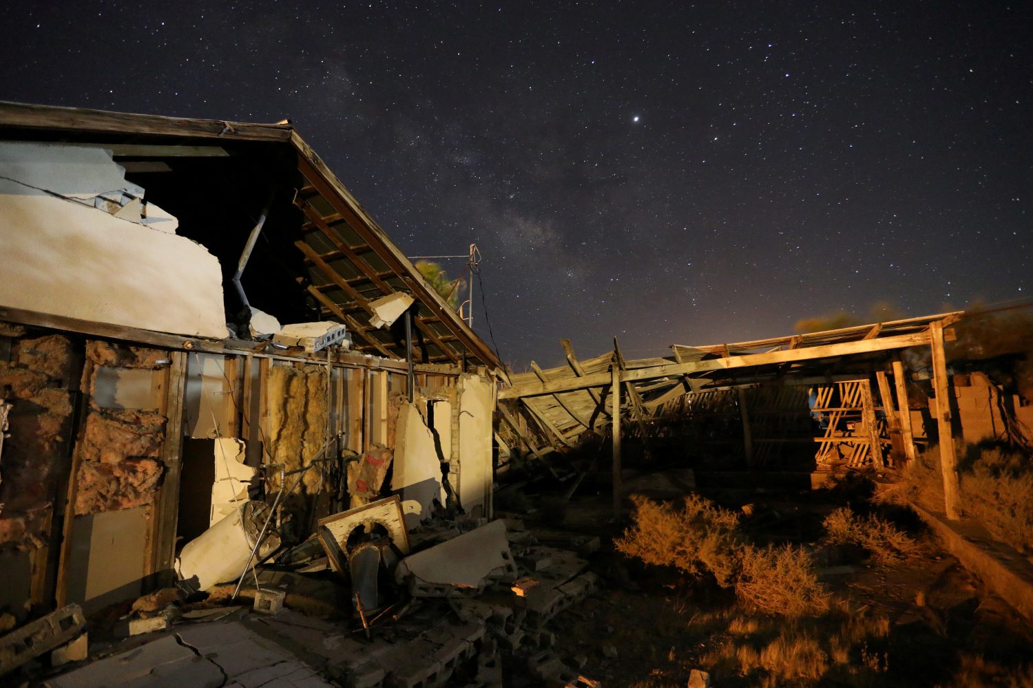
FILE PHOTO - A house left destroyed by a powerful magnitude 7.1 earthquake, triggered by a 6.4 the previous day, is seen at night near the epicenter in Trona, California, U.S., July 6, 2019. REUTERS/David McNew

By Alex Dobuzinskis

LOS ANGELES (Reuters) – California officials are spending more than $40 million on an earthquake early warning system that in addition to alerting the public could also be used to automatically halt trains and open fire station doors moments before a major tremor actually strikes.

California Governor Gavin Newsom announced after a magnitude 7.1 quake shook Southern California on Friday that the state has already installed 70 percent of the 1,115 early detection sensors it needs to have the system in place statewide.

“I think the whole state’s on notice right now about the opportunity that’s in front of us,” said Ryan Arba, chief of seismic hazards under the governor’s Office of Emergency Services (OES).

Emergency management officials have said they intend to have the statewide warning system in place by mid-2021 to serve California’s roughly 40 million residents.

In a jolt that grabbed the attention of seismically jaded Californians, Friday’s magnitude 7.1 temblor ruptured gas lines and sparked numerous fires in Ridgecrest, a remote town of fewer than 30,000 people in the Mojave Desert, about 125 miles (200 km) northeast of Los Angeles. It came one day after a 6.4 quake in the same area.

The back-to-back quakes ended a period of relative seismic calm in Southern California and brought renewed awareness to development of the state’s early warning system for earthquakes.

Japan developed the world’s most advanced earthquake early warning system after the 1995 Kobe earthquake. It relies on more than 4,000 sensors and is based on the same principles of physics that California is using to build its system.

FAST-MOVING P-WAVES

Like in Japan, the California network is designed to detect the fast-moving seismic P-waves that are unleashed by earthquakes and can reach a sensor before the ground starts moving in a given area. Many animals are able to feel P-waves, according to the U.S. Geological Survey (USGS).

In general, communities farthest away from the epicenter of a quake would receive the most advance warning.

In a best-case scenario, a rupture of the San Andreas Fault near California’s border with Mexico would be far enough away from Los Angeles to give the nation’s second-largest city 60 seconds of warning before ground motion from the quake actually arrives, Arba said. Communities very close to a quake’s origin would receive little or no warning.

Officials in Los Angeles County in January introduced a “ShakeAlertLA” mobile phone application that can transmit an early warning to residents who have installed the app, giving them extra seconds to take cover before a major quake hits.

The “ShakeAlertLA” app was not activated for either of the Ridgecrest earthquakes because the projected intensity of shaking for Los Angeles County was below required thresholds, the U.S. Geological Survey said.

Officials plan to eventually expand the system statewide and to tie it into the operations of medical facilities, emergency responders, power companies, hazardous materials management, mass transit and other workplaces to minimize damage and injuries, according to OES.

Already, the Bay Area Rapid Transit (BART) system in and around San Francisco has connected the early detection network to its rail service to automatically slow down its trains, and hopefully reduce the risk of a derailment, if a major earthquake is about to strike, Arba said.

Southern California’s Metrolink commuter rail system halted service after Friday’s 7.1 earthquake in Ridgecrest, but orders to stop the trains only went out by radio when shaking was felt by officials at the operations center in Pomona, east of Los Angeles, Metrolink spokesman Scott Johnson said.

The Metrolink board has voted to spend $4.9 million in state funds to eventually automate the halting of its trains via the quake detection and warning system, Johnson said.

Two fire stations in the Silicon Valley community of Menlo Park in Northern California are likewise connected to seismic sensors so that detection of a large quake raises their doors, Arba said. Officials hope to have other fire stations take similar precautions.

In hospitals, an early warning system would allow doctors performing surgery to pause before shaking begins to prevent any harm to their patients, and in tall buildings elevators could be equipped to automatically descend to the ground floor, according to OES.

University of California at Los Angeles engineering professor John Wallace said the potential uses of the early warning system are widespread and have not all been mapped out.

“Once you provide the system, you’d be surprised how many ways people will find to use it to their benefit,” he said.

(Reporting by Alex Dobuzinskis; Editing by Sandra Maler)

Californians jolted by strong aftershock following strongest quake in 25 years

A house is seen damaged from a powerful earthquake that struck Southern California, near the epicenter, northeast the city of Ridgecrest, California, U.S., July 4, 2019. REUTERS/David McNew

By David McNew

RIDGECREST, Calif. (Reuters) – A strong aftershock shook Southern California early on Friday as residents were still assessing the damage from the strongest earthquake in the region in 25 years on July 4, which was felt by more than 20 million people.

The 5.4 magnitude aftershock, the biggest so far, struck the same desert region as Thursday’s earthquake. Its epicenter was about 11 miles (18 km) west of Searles Valley at 4:07 a.m., the U.S. Geological Survey said.

The aftershock was felt in Los Angeles, about 150 miles (240 km) to the south, and the surrounding area, with many residents posting on Twitter that they were awakened by it.

There had already been more than 80 smaller aftershocks since Thursday’s 6.4 magnitude quake near the city of Ridgecrest, which was felt from Los Angeles to Las Vegas, USGS seismologist Lucy Jones said.

“We should be expecting lots of aftershocks and some of them will be bigger than the 3s we’ve been having so far,” Jones told reporters on Thursday. “I think the chance of having a magnitude 5 … is probably greater than 50-50.”

Only a few injuries were reported in Thursday’s quake, but two houses caught fire from broken gas pipes, officials said.

Water gushed from zigzagged cracks in the pavement from busted water lines. Deep fissures snaked across the Mojave Desert, with passersby stopping to take selfies while standing in the rendered earth.

The quake sent 30 residents of the desert community of 28,000 to emergency shelters, knocked some houses off their foundations and left many homeowners wondering if their insurance would cover the damage, Ridgecrest Mayor Peggy Breeden said.

“The most important thing is that we have not had any loss of life or any major personal damage to people,” Breeden told CNN on Friday.

Breeden said officials were still assessing the extent of the damage, but added that emergency state and federal aid would enable the city’s overwhelmed agencies to start the cleanup without worrying about their budgets.

The quake hit the edge of Death Valley National Park about 113 miles northeast of Los Angeles at about 10:30 a.m. on Thursday. It was very shallow, only 6.7 miles (10.7 km) deep, amplifying its effect, and was felt in an area inhabited by 20 million people, the European quake agency EMSC said.

The Ridgecrest Regional Hospital, where 15 patients were evacuated earlier, appeared intact apart from some new cracks in the walls.

The quake is the largest in Southern California since the 1994 magnitude 6.6 Northridge earthquake, USGS geophysicist Paul Caruso said. That quake, which was centered in a heavily populated area of Los Angeles, killed 57 people and caused billions of dollars of damage.

(Reporting by David McNew; additional reporting by Bill Tarrant in Los Angeles, Sandra Maler in Washington, Lisa Richwine in Los Angeles, Gabriella Borter and Daniel Trotta and Peter Szekely in New York, Lizbeth Diaz in Mexico City and Rich McKay in Atlanta; Editing by Chizu Nomiyama and Grant McCool)