California expanding early quake detection and warning system

FILE PHOTO - A house left destroyed by a powerful magnitude 7.1 earthquake, triggered by a 6.4 the previous day, is seen at night near the epicenter in Trona, California, U.S., July 6, 2019. REUTERS/David McNew

By Alex Dobuzinskis

LOS ANGELES (Reuters) – California officials are spending more than $40 million on an earthquake early warning system that in addition to alerting the public could also be used to automatically halt trains and open fire station doors moments before a major tremor actually strikes.

California Governor Gavin Newsom announced after a magnitude 7.1 quake shook Southern California on Friday that the state has already installed 70 percent of the 1,115 early detection sensors it needs to have the system in place statewide.

“I think the whole state’s on notice right now about the opportunity that’s in front of us,” said Ryan Arba, chief of seismic hazards under the governor’s Office of Emergency Services (OES).

Emergency management officials have said they intend to have the statewide warning system in place by mid-2021 to serve California’s roughly 40 million residents.

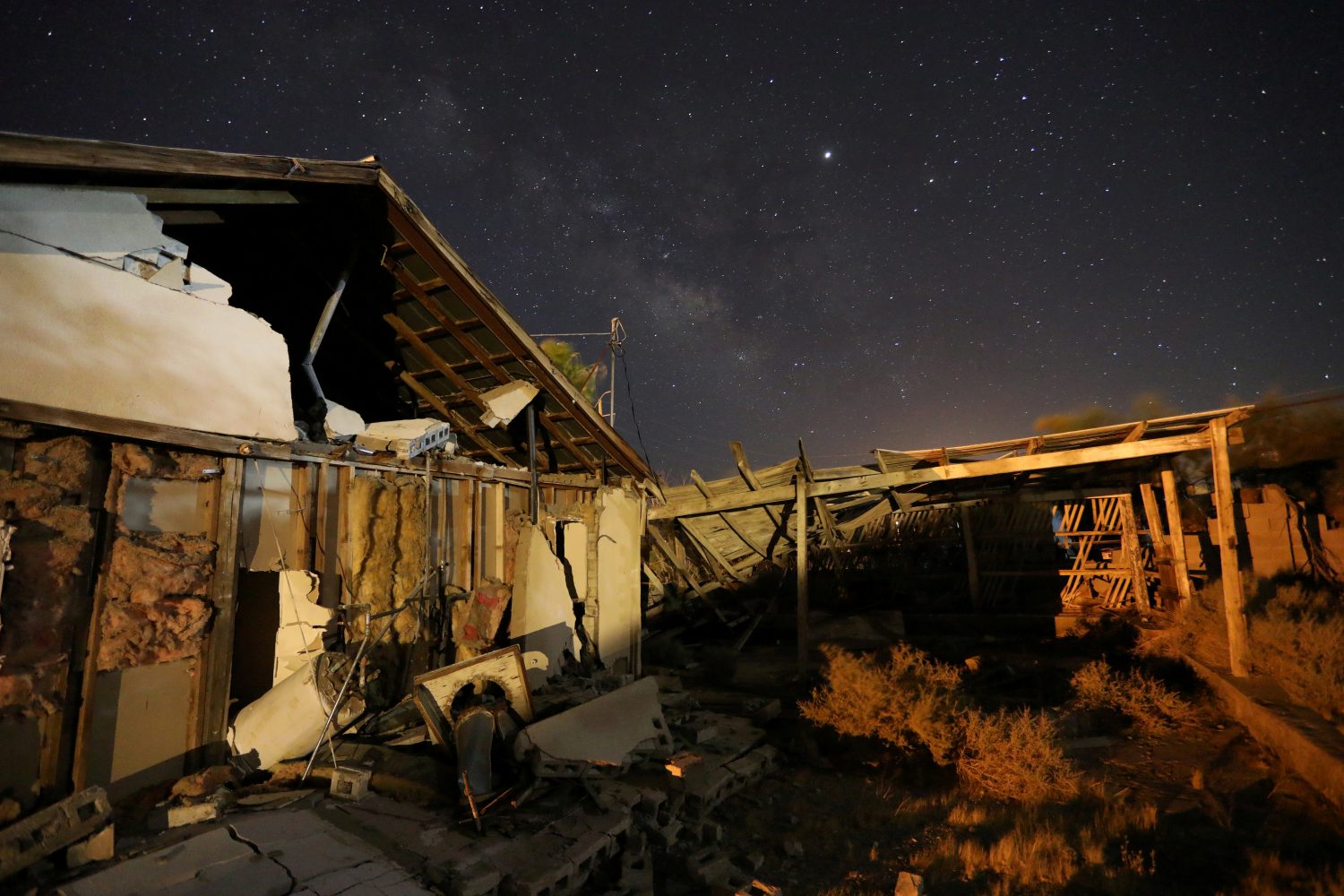
In a jolt that grabbed the attention of seismically jaded Californians, Friday’s magnitude 7.1 temblor ruptured gas lines and sparked numerous fires in Ridgecrest, a remote town of fewer than 30,000 people in the Mojave Desert, about 125 miles (200 km) northeast of Los Angeles. It came one day after a 6.4 quake in the same area.

The back-to-back quakes ended a period of relative seismic calm in Southern California and brought renewed awareness to development of the state’s early warning system for earthquakes.

Japan developed the world’s most advanced earthquake early warning system after the 1995 Kobe earthquake. It relies on more than 4,000 sensors and is based on the same principles of physics that California is using to build its system.

FAST-MOVING P-WAVES

Like in Japan, the California network is designed to detect the fast-moving seismic P-waves that are unleashed by earthquakes and can reach a sensor before the ground starts moving in a given area. Many animals are able to feel P-waves, according to the U.S. Geological Survey (USGS).

In general, communities farthest away from the epicenter of a quake would receive the most advance warning.

In a best-case scenario, a rupture of the San Andreas Fault near California’s border with Mexico would be far enough away from Los Angeles to give the nation’s second-largest city 60 seconds of warning before ground motion from the quake actually arrives, Arba said. Communities very close to a quake’s origin would receive little or no warning.

Officials in Los Angeles County in January introduced a “ShakeAlertLA” mobile phone application that can transmit an early warning to residents who have installed the app, giving them extra seconds to take cover before a major quake hits.

The “ShakeAlertLA” app was not activated for either of the Ridgecrest earthquakes because the projected intensity of shaking for Los Angeles County was below required thresholds, the U.S. Geological Survey said.

Officials plan to eventually expand the system statewide and to tie it into the operations of medical facilities, emergency responders, power companies, hazardous materials management, mass transit and other workplaces to minimize damage and injuries, according to OES.

Already, the Bay Area Rapid Transit (BART) system in and around San Francisco has connected the early detection network to its rail service to automatically slow down its trains, and hopefully reduce the risk of a derailment, if a major earthquake is about to strike, Arba said.

Southern California’s Metrolink commuter rail system halted service after Friday’s 7.1 earthquake in Ridgecrest, but orders to stop the trains only went out by radio when shaking was felt by officials at the operations center in Pomona, east of Los Angeles, Metrolink spokesman Scott Johnson said.

The Metrolink board has voted to spend $4.9 million in state funds to eventually automate the halting of its trains via the quake detection and warning system, Johnson said.

Two fire stations in the Silicon Valley community of Menlo Park in Northern California are likewise connected to seismic sensors so that detection of a large quake raises their doors, Arba said. Officials hope to have other fire stations take similar precautions.

In hospitals, an early warning system would allow doctors performing surgery to pause before shaking begins to prevent any harm to their patients, and in tall buildings elevators could be equipped to automatically descend to the ground floor, according to OES.

University of California at Los Angeles engineering professor John Wallace said the potential uses of the early warning system are widespread and have not all been mapped out.

“Once you provide the system, you’d be surprised how many ways people will find to use it to their benefit,” he said.

(Reporting by Alex Dobuzinskis; Editing by Sandra Maler)

Indonesia’s latest tsunami raises global questions over disaster preparedness

Debris are seen after the tsunami damage at Sunda strait at Kunjir village in South Lampung, Indonesia, December 28, 2018. Antara Foto/Ardiansyah via REUTERS

By Fergus Jensen and Fanny Potkin

CIGONDONG/JAKARTA, Indonesia (Reuters) – As Indonesia reels from the carnage of yet another natural disaster, authorities around the globe are working on how they can prepare for the kind of freak tsunami that battered coasts west of Jakarta this month.

The Dec. 23 tsunami killed around 430 people along the coastlines of the Sunda Strait, capping a year of earthquakes and tsunamis in the vast archipelago, which straddles the seismically active Pacific Ring of Fire.

No sirens were heard in those towns and beaches to alert people before the deadly series of waves hit shore.

Seismologists and authorities say a perfect storm of factors caused the tsunami and made early detection near impossible given the equipment in place.

But the disaster should be a wake-up call to step up research on tsunami triggers and preparedness, said several of the experts, some of whom have traveled to the Southeast Asian nation to investigate what happened.

“Indonesia has demonstrated to the rest of the world the huge variety of sources that have the potential to cause tsunamis. More research is needed to understand those less-expected events,” said Stephen Hicks, a seismologist at the University of Southampton.

Most tsunamis on record have been triggered by earthquakes. But this time it was an eruption of Anak Krakatau volcano that caused its crater to partially collapse into the sea at high tide, sending waves up to 5 meters (16 feet) high smashing into densely populated coastal areas on Java and Sumatra islands.

During the eruption, an estimated 180 million cubic meters, or around two-thirds of the less-than-100-year-old volcanic island, collapsed into the sea.

But the eruption didn’t rattle seismic monitors significantly, and the absence of seismic signals normally associated with tsunamis led Indonesia’s geophysics agency (BMKG) initially to tweet there was no tsunami.

Muhamad Sadly, head of geophysics at BMKG, later told Reuters its tidal monitors were not set up to trigger tsunami warnings from non-seismic events.

The head of Japan’s International Research Institute of Disaster, Fumihiko Imamura, told Reuters he did not believe Japan’s current warning system would have detected a tsunami like the one in the Sunda Strait.

“We still have some risks of this in Japan…because there’s 111 active volcanoes and low capacity to monitor eruptions generating a tsunami,” he said in Jakarta.

Scientists have long flagged the collapse of Anak Krakatau, around 155 km (100 miles) west of the capital, as a concern. A 2012 study published by the Geological Society of London deemed it a “tsunami hazard.”

Anak Krakatau has emerged from the Krakatoa volcano, which in 1883 erupted in one of the biggest explosions in recorded history, killing more than 36,000 people in a series of tsunamis and lowering the global surface temperature by one degree Celsius with its ash.

BROKEN WARNING SYSTEM

Some experts believe there was enough time for at least a partial detection of last week’s tsunami in the 24 minutes it took waves to hit land after the landslide on Anak Krakatau.

But a country-wide tsunami warning system of buoys connected to seabed sensors has been out of order since 2012 due to vandalism, neglect and a lack of public funds, authorities say.

“The lack of an early warning system is why Saturday’s tsunami was not detected,” said disaster agency spokesman Sutopo Nugroho, adding that of 1,000 tsunami sirens needed across Indonesia, only 56 are in place.

“Signs that a tsunami was coming weren’t detected and so people did not have time to evacuate.”

President Joko Widodo this week ordered BMKG to purchase new early warning systems, and the agency later said it planned to install three tsunami buoys on the islands surrounding Anak Krakatau.

The cost of covering the country is estimated at 7 trillion rupiah ($481.10 million). That is roughly equivalent to Indonesia’s total disaster response budget of 7.19 trillion rupiah for 2018, according to Nugroho.

But other experts say even if this network had been working, averting disaster would have been difficult.

“The tsunami was very much a worst-case scenario for any hope of a clear tsunami warning: a lack of an obvious earthquake to trigger a warning, shallow water, rough seabed, and the close proximity to nearby coastlines,” said seismologist Hicks.

In the Philippines, Renato Solidum, undersecretary for disaster risk reduction, said eruptions from the country’s Taal volcano had caused tsunami waves before in the surrounding Taal Lake.

He told Reuters that what happened in Indonesia showed the need to “re-emphasize awareness and preparedness” regarding volcanic activity and its potential to trigger tsunamis in the Philippines.

The United States has also suffered several tsunamis caused by volcanic activity, including in Alaska, Hawaii, and Washington, according to the national weather service.

MORE EDUCATION

In Indonesia earlier this year, a double quake-and-tsunami disaster killed over 2,000 people on Sulawesi island, while at least 500 died when an earthquake flattened much of the northern coastline of the holiday island of Lombok.

In a country where, according to government data, 62.4 percent of the population is at risk of being struck by earthquakes and 1.6 percent by tsunamis, attention is now focused on a continued lack of preparedness.

“Given the potential for disasters in the country, it’s time to have disaster education be part of the national curriculum,” Widodo told reporters after the latest tsunami.

For Ramdi Tualfredi, a high school teacher who survived last week’s waves, these improvements cannot come soon enough.

He told Reuters that people in his village of Cigondong on the west coast of Java and close to Krakatau had never received any safety drills or evacuation training.

“I’ve never received education on safety steps,” he said.

“The system…totally failed.”

(Additional reporting by Wilda Asmarini, Tabita Diela, Bernadette Christina Munthe in Jakarta, Linda Sieg and Tanaka Kiyoshi in Tokyo, and Neil Jerome Morales in Manila.; Writing by Kanupriya Kapoor; Editing by Raju Gopalakrishnan)

Indonesia’s double disaster exposes earthquake lessons not learned

A man salvages wood from the ruins of a house in the Petobo neighbourhood which was hit by an earthquake and liquefaction in Palu, Central Sulawesi, Indonesia October 10, 2018. REUTERS/Darren Whiteside

By Kanupriya Kapoor

PALU, Indonesia (Reuters) – The young man standing atop a mound of gray mud and debris on the Indonesian island of Sulawesi, waiting for an excavator he hoped would dig out the bodies of his parents, voiced the exasperation many feel in his earthquake-plagued country.

“This is something that happens all the time in Indonesia. Why aren’t we getting better at handling it?” Bachtiar cried as the machine clanked through the ruins of someone’s kitchen in the city of Palu.

A 7.5-magnitude earthquake on Sept. 28 triggered a tsunami and extensive soil liquefaction, a phenomenon that turns soft soil into a seething mire, killing 2,073 people, according to the latest official estimate. Up to 5,000 more may be missing.

“In every disaster, there’s always a lesson to be learned,” Sutopo Purwo Nugroho, spokesman for the national disaster mitigation agency, said this week.

Nugroho conceded that Indonesia’s preparedness for disasters and capacity to respond still fall woefully short, not least because public funding is so low. He said the country’s disaster response budget is currently 4 trillion rupiah ($262 million) a year, equivalent to 0.002 percent of the state budget.

“We should not forget that there will be many disasters to come. It needs budget,” he said. “We need to learn from Japan as they are consistent in preparation.”

Critics say that, despite improvements at a national level in disaster management since a devastating Indian Ocean tsunami in 2004, local authorities often lack know-how and equipment, and so rescue efforts are delayed until the military can reach the area.

Also, a lack of education and safety drills means people don’t know how to protect themselves when an earthquake strikes.

Palu was Indonesia’s second earthquake disaster of 2018. In August, the island of Lombok was rocked by quakes that flattened villages and killed more than 500 people.

It was also only the latest in a string of deadly tsunamis to hit the archipelago in 2005, 2006 and 2010. But none of those compare with the 2004 tsunami that killed some 226,000 people in 13 countries, more than 120,000 of them in Indonesia alone.

Indonesia straddles the southwestern reaches of the Pacific Ring of Fire and is practically defined by the tectonic plates that grind below its lush islands and blue seas.

The archipelago is strung out along a fault line under the Indian Ocean off its west coast. Others run northwards in the Western Pacific, including those under Sulawesi.

Volcanoes that dot the islands have brought fiery destruction and remarkable fertility, but rapid population growth over recent decades means that many more people are now living in hazardous areas.

For a graphic on destruction in Palu, click https://tmsnrt.rs/2IDFukK

‘NEW SCIENCE’

The biggest – and most unexpected – killer in Sulawesi was soil liquefaction, a phenomenon where intense tremors cause saturated sand and silt to take on the characteristics of a liquid.

The liquefaction swallowed up entire neighborhoods of Palu.

With communications and power down, rescuers focused first on Palu’s tsunami-battered beachfront in the north and on collapsed hotels and shopping centers in its business district.

Roads to the south, where the city has spread out as it has grown, were initially impassable – damaged or blocked by debris.

So it took days for rescuers to reach the neighborhoods of Balaroa, Petobo, and Sigi, where traumatized survivors said the ground came alive when the quake hit, swallowing up people, vehicles and thousands of homes.

Liquefaction is a fairly common characteristic of high-magnitude earthquakes, but the Indonesian government says there is still insufficient understanding of the phenomenon and how to reduce exposure to it.

“Liquefaction is a new science. There are no guidelines on how to handle it,” Antonius Ratdomopurbo, secretary of the Geological Agency at the Ministry of Energy and Mineral Resources, told reporters this week.

‘EDUCATION’

A tsunami warning system set up after 2004 failed to save lives in Sulawesi: it emerged too late that, due to neglect or vandalism, a network of 22 buoys connected to seabed sensors had been inoperable since 2012.

With power and communications knocked out in Palu, there was no hope of warning people through text messages or sirens that tsunami waves of up to six meters (20 feet) were racing towards the city.

But that highlights what some experts say is the most important lesson: No one in a coastal area should wait for a warning if they feel a big quake.

“The earthquake is the warning,” said Adam Switzer, a tsunami expert at the Earth Observatory of Singapore. “It’s about education.”

Unlike in quake-prone Japan and New Zealand, earthquake education and drills are only sporadic in Indonesia, so there is little public awareness of how to respond.

“The problem in tsunami early warning systems is not the structure … but the culture in our communities,” said Nugroho.

That culture includes a resilience that emerged within days as the people of Palu picked up the pieces of their lives.

“Palu is not dead,” is daubed on a billboard by the beach.

Eko Joko, his wife and two children have been salvaging wood and metal to reconstruct their flattened beachfront shop-house.

“I tell my family they have to be strong, not scared so that I can be strong,” said Joko, 41.

“This disaster has not destroyed us.”

(Additional reporting by Bernadette Christina Munthe in Jakarta; Editing by Robert Birsel and John Chalmers)

Scientists test warning system as asteroid flies by

Scientists test warning system as asteroid flies by

FRANKFURT (Reuters) – An asteroid the size of a school bus flew remarkably near Earth on Thursday, providing scientists with an opportunity to test the warning systems that would kick in if a space collision was coming.

Asteroid 2012 TC4 came close — passing Earth at a distance of only around 44,000 km (27,000 miles), which is nothing in Universe terms.

There was no actual risk of a hit, although the asteroid did come well inside the orbit of the Moon and that of some human-made satellites.

“Basically, we pretended that this is a ‘critical’ object with a high risk of impacting Earth … and exercised our communication channels and used telescopes and radar systems for observations,” Detlef Koschny of European Space Agency said in a blog post on the agency’s website.

The results were mixed.

Koschny said one big radar system in Puerto Rico did not work due to damage from Hurricane Maria but that another U.S. based radar system was used instead.

“This is exactly why we do this exercise – to not be surprised by these things,” he said.

Radar images showed the asteroid was about 10 to 12 meters (yards) wide, roughly the size of an asteroid that exploded over Chelyabinsk, Russia in 2013, leaving more than 1,000 people injured by flying glass and debris.

Koschny said the ESA now needed to update its predictions for how close 2012 TC4 will come to Earth on its next flyby, which has so far been forecast for 2079.

(Reporting by Maria Sheahan; Editing by Jeremy Gaunt)

Bitter lessons of Japan’s 2011 tsunami put to use with latest quake

A tidal surge is seen in Sunaoshi River after tsunami advisories were issued following an earthquake in Tagajo, Miyagi prefecture, Japan November 22, 2016, in this video grab image released by Miyagi Prefectural Police via Kyodo. Mandatory credit

TOKYO, Nov 22 (Reuters) – Massive tsunami waves slammed into Japan’s northeastern coast more than five years ago, killing about 18,000 people and prompting authorities to revise warning systems and evacuation plans to try to save more lives.

On Tuesday, when a magnitude 7.4 quake hit the same area, the country swung into action, using lessons learned in the March 11, 2011, disaster to ensure coastal residents evacuated well before the much smaller waves hit.

In 2011, warning broadcasts were mostly limited to television, radio, and city officials on loudspeakers, with volunteer firemen in trucks roaming the roads, telling residents to flee to higher ground.

But on the day now known as “3/11,” some of these failed due to power outages after the magnitude 9.0 quake, while many firefighters were killed when the waves – 30 metres (100 feet) high in places – rushed ashore.

“A lot of people told us they weren’t able to hear any of the broadcasts, the waves were bigger than expected, and many went back after the first one to check things out,” said Tsunetaka Omine, a disaster official in Iwaki, a city where around 460 residents died in 2011.

Iwaki now blasts warnings to every mobile phone in the area, sends email messages and broadcasts on local radio in addition to the older methods.

Previous elaborate systems designating specific evacuation centres have also been abandoned along the coast in many cases as too complicated. Some designated areas were too low and became death traps where scores seeking safety drowned.

“Now, we basically just tell people to stay away from the sea, to head to the highest possible ground,” Omine said.

As a result, as sirens wailed shortly after dawn on Tuesday, ships headed out of harbours to deeper water and lines of cars snaked up nearby hills.

Public broadcaster NHK, a key player in disaster prevention, revamped its broadcasts after 2011 in response to criticism that it had been too calm in its reporting, leading some to take
warnings less seriously.

So on Tuesday, announcers abandoned their usual careful modulation for an unsettling note of urgency, repeatedly telling listeners, “Do not go near the water, a tsunami is coming!” as messages flashed on the screen in red saying “Tsunami! Run!”

And in a nod to a growing number of foreign residents, a dubbed version of the NHK channel broadcast warnings in English, Chinese and Korean. Several young foreign English teachers died in 2011, prompting speculation they had not known of the danger.

Kathy Krauth, a teacher with a Tokyo international school leading a dozen students on a study tour, was staying at a traditional Japanese inn in the coastal town of Ofunato and was evacuated to higher ground soon after the quake struck.

Four hours later, the group was finally allowed back to their inn – and were promptly relocated to a hotel at a higher, safer elevation.

“I felt like the lessons of 3/11 were really taken to heart,” Krauth said. “The feeling was, we just don’t know, but we’re going to be as cautious as we can.”

(Additional reporting by Malcolm Foster; Editing by Lincoln Feast)