Hurricane Ian heads to Cuba as Florida prepares for mid-week impact

Revelation 16:9 “They were scorched by the fierce heat, and they cursed the name of God who had power over these plagues. They did not repent and give him glory.”

Important Takeaways:

  • Ian Strengthens Into a Hurricane, Heads Toward Cuba, Florida
  • Authorities in Cuba suspended classes in Pinar del Rio province and said they will begin evacuations
  • A hurricane warning was in effect for Grand Cayman and the Cuban provinces of Isla de Juventud, Pinar del Rio and Artemisa
  • It could become a major hurricane before a likely landfall in Florida around the middle of the week, possibly the state’s western coast or Panhandle
  • Ron DeSantis has declared a state of emergency throughout Florida and urged residents to prepare for the storm to lash large swaths of the state with heavy rains, high winds and rising seas.
  • Local media in Florida have reported a consumer rush on water, generators and other supplies in some areas where residents moved to stock up on goods ahead of the storm.

Read the original article by clicking here.

Hurricane Rick loses steam as it moves further inland Mexico

MEXICO CITY (Reuters) -Hurricane Rick’s strong winds lost some steam as the storm moved further inland on Monday, though its heavy rains still had the potential to trigger flash flooding and mudslides, the U.S. National Hurricane Center (NHC) and local authorities said.

Rick was packing maximum sustained winds of 80 miles per hour (130 km/h), down from 105 mph, and was some 40 miles (65 kilometers) north of the port of Lazaro Cardenas in Michoacán state as of 10:00 A.M. local time (1500 GMT), the Miami-based NHC said in a public advisory.

The storm came ashore on Mexico’s Pacific coast earlier in the day.

“Rapid weakening is expected today while Rick continues to move over land, and Rick is forecast to dissipate over the mountainous terrain of southern Mexico tonight or Tuesday,” the NHC said.

Rick is forecast to move farther inland over southern Mexico throughout Monday and possibly into Tuesday, and is expected to produce 5 to 10 inches of rain, with isolated storm total amounts of 20 inches across parts of the Mexican states of Guerrero and Michoacán through Tuesday.

The heavy rains “will likely produce flash flooding and mudslides,” the NHC said.

The heavy rains may trigger landslides, raise the water levels of rivers and streams, and cause flooding in low-lying areas, Mexico’s National Water Commission, CONAGUA, said in a statement.

CONAGUA urged residents in the southern parts of those states to heed the civil protection agency warning to stay indoors as of Sunday evening.

Guerrero’s education ministry said classes in the coastal area would be suspended on Monday, warning of intense rain, strong gusts of wind and high waves in the Costa Grande region.

Officials in Guerrero and Michoacán as well as the coastal states of Colima, Jalisco and Nayarit were opening shelters in areas expected to get downpours, a government official told Televisa News.

(Reporting by Anthony Esposito; editing by Barbara Lewis and Chizu Nomiyama)

Nepal floods and landslides kill at least 77

By Gopal Sharma

KATHMANDU (Reuters) -The death toll after three days of heavy rain in Nepal triggered landslides and flash floods rose to 77 on Wednesday after rescuers recovered 34 more bodies, authorities said.

Twenty-four deaths have been reported in the Panchthar district of east Nepal bordering India, 13 in neighboring Ilam and 12 in Doti in west Nepal, interior ministry official Dil Kumar Tamang said. Others died elsewhere in west Nepal.

The ministry said 22 people were injured and 26 were missing.

Authorities said the government would provide $1,700 as relief to the families of each dead victim and free treatment for the injured.

About 350 km (220 miles) west of the capital Kathmandu, persistent heavy rains were hampering efforts to reach Seti, a village in west Nepal where 60 people have been marooned by floods for two days.

“Rescuers were unable to reach the village due to bad weather and continuous rains yesterday. Rescue efforts are continuing today,” Police spokesman Basanta Kunwar told Reuters.

Television channels showed rice paddy crops submerged or washed away, and rivers sweeping away bridges, roads, houses and the runway of an airport in the city of Biratnagar.

Flash floods and landslides are common in Nepal during the monsoon season from mid-June through September.

Authorities have warned of more rain in the next few days.

There are “chances of heavy rainfall in some places and light to moderate snowfall” in the eastern mountainous areas, the Department of Hydrology and Meteorology said in a forecast for the next two days.

(Reporting by Gopal Sharma; Editing by Lincoln Feast and Giles Elgood)

More than 20 dead after floods hit southern India

By Jose Devasia

KOCHI, India (Reuters) – Leaders in the southern Indian state of Kerala opened near-overflowing dams on Monday after at least 22 people died when heavy rains lashed the region over the weekend.

Rainfall across Kerala triggered flash floods and landslides in several areas, with the Indian army and navy called out to rescue residents.

Opening dams could reduce the risk of potentially catastrophic overflows like those partly blamed for the state’s worst floods in a century in 2018, when at least 400 people were killed and 200,000 displaced. But by releasing water downstream, areas already experiencing floods could suffer more.

Authorities have already opened smaller dams to prevent flooding, Kerala Power Minister K Krishnankutty said in a statement, while the state’s largest, the Idukki dam, will also be opened on Tuesday morning local time.

Sheeba George, the top official in Idukki district, told local media that dozens of families had been evacuated from their homes ahead of the dam openings.

At least 13 people were killed by a landslide in the village of Kuttikkal, officials and witnesses said.

“There were four landslides that happened there yesterday, the hill behind me, which brought water and other items downwards,” a local resident told Reuters partner ANI on Sunday, standing in front of a now-barren hillside.

P.K. Jayasree, the top government official in Kottayam district where the landslide took place, said six of the dead were from a single family.

Kerala will receive further widespread rain, including isolated heavy downpours in many areas, for two to three days from Oct. 20, the state government said on Monday.

(Reporting Jose Devasia in Kochi; Writing by Alasdair Pal; Editing by Peter Graff and Mark Heinrich)

Hurricane Grace strengthens, bears down on Mexico’s Gulf coast

MEXICO CITY (Reuters) – Hurricane Grace gathered strength as it barreled towards Mexico’s Gulf coast on Friday morning, threatening to lash the oil-producing state of Veracruz and central Mexico with strong winds and heavy rains.

Grace, a Category 1 Hurricane, is forecast to strengthen further before it plows into the coast of Veracruz late on Friday or in the early hours of Saturday, the National Hurricane Center (NHC) said.

It should then weaken rapidly as it dissipates over land during the weekend, the Miami-based NHC said.

Veracruz and its waters are home to several oil installations including Petroleos Mexicanos’ Lazaro Cardenas refinery in Minatitlan in the south of the state. Current forecasts showed Grace expected to hit Veracruz well to the north of the city.

Through Sunday, the NHC said Grace would dump 6-12 inches (15-30 cm) of rain over large swathes of eastern and central Mexico, and up to 18 inches in some areas. The heavy rainfall would likely cause areas of flash and urban flooding, it added.

“We ask the population to be very alert,” Laura Velazquez, head of Mexico’s civil protection authority, told a regular news conference with President Andres Manuel Lopez Obrador.

Grace pounded Mexico’s Caribbean coast on Thursday, downing trees and causing power outages for nearly 700,000 people, but without causing loss of life, authorities said. Earlier in the week, it doused Jamaica and Haiti with torrential rain.

By Friday morning, Grace was about 185 miles (298 kilometers) east-northeast of the city of Veracruz, blowing maximum sustained winds of 85 miles per hour (137 km per hour), and moving west at 15 mph (24 kph), the NHC said.

(Reporting by Dave Graham; Editing by Frances Kerry)

Hawaii declares emergency due to floods, orders evacuations

By Kanishka Singh

(Reuters) – Hawaii Governor David Ige declared an emergency in the U.S. state after heavy rains brought floods, landslides and fear of dam failures, and authorities ordered the evacuation of several thousand people from communities threatened by rising waters.

The move came after a dam overflowed on the island of Maui, forcing evacuations and destroying homes, with the dam’s “unsatisfactory” condition leading to it being scheduled for removal this year, the land department has said.

“The emergency proclamation makes state general funds available that can be used quickly and efficiently to help those impacted by the severe weather,” Ige said on Tuesday.

Poor weather was expected to run until Friday, he added, and flood advisories stayed in place for a second day

The emergency declaration covers the counties of Hawai’i, Maui, Kalawao, O’ahu and Kaua’i, the governor’s office said in a statement, while the disaster relief period runs until May 8.

The Honolulu Department of Emergency Management directed people to leave Haleiwa, a community of a few thousand people to the north of state capital Honolulu.

Hawaii News Now reported that two people were swept away in raging waters on Tuesday. One of them, a 27-year-old man, was rescued by authorities. A search for the other would resume on Wednesday, according to the report.

There were no other immediate reports of injuries or casualties.

In Maui, heavy rains damaged roads, leaving them impassable, with one bridge completely washed out and another displaced, the governor’s office said.

State emergency management officials had said the rains led to the cresting of the Kaupakalua dam in the northern region of Haiku, prompting authorities to open evacuation shelters and urge people not to return home.

Six homes were heavily damaged or destroyed, said Maui mayor Michael Victorino.

(Reporting by Kanishka Singh in Bengaluru; Editing by Himani Sarkar, Clarence Fernandez & Simon Cameron-Moore)

Hurricane’s heavy rains to dampen fuel demand, offshore sites closed

By Erwin Seba

HOUSTON (Reuters) – More than one-quarter of U.S. Gulf of Mexico offshore oil and gas production remains shut due to Hurricane Sally, and as it moves inland, it is expected to cut fuel demand in the U.S. southeast as forecasters warn of life-threatening flooding.

The storm made landfall on Gulf Shores, Alabama, as a Category Two hurricane on Wednesday morning. Oil prices rose early Wednesday, attributed in part to the expectation of a temporary drop in U.S. production.

Nearly 500,000 bpd of offshore crude oil production and 759 million cubic feet per day (mmcfd) of natural gas output were shut in the U.S. Gulf of Mexico, according to the U.S. Interior Department. That’s roughly one-third of the shut-ins caused by Hurricane Laura, which landed further west in August.

Oil and chemical ports along the Mississippi River were moving to reopen with restrictions and some offshore operators were preparing to return workers to offshore platforms on Thursday.

The hurricane was between Gulf Shores and Pensacola, heading northeast at 3 mph (5 kph), with sustained winds of 100 mph (160 kph), the National Hurricane Center said in an update at around 7 a.m. CDT (1200 GMT).

OIL PRICES RISE

Crude oil futures rose more than 2% on Wednesday, extending the previous session’s gains caused by the shut-ins and an industry report forecasting a drop in U.S. crude stockpiles.

“Even if the weather keeps production shut for a couple of days, the sheer volume of its size is enough for the market to breathe a bit,” said Rystad Energy senior oil markets analyst Paola Rodriguez-Masiu in a comment.

The NHC earlier warned Sally could drop 10 to 20 inches (25-50 cm) of rain and up to 30 inches in some spots. It warned of “catastrophic and life-threatening” flooding along portions of the northern Gulf Coast.

(Reporting by Erwin Seba in Houston and Stephanie Kelly in New York; editing by xxx)

Australia’s bushfire-stricken east welcomes drenching rain

By Lidia Kelly

MELBOURNE (Reuters) – Intense thunderstorms with heavy rains dampened bushfires on Australia’s east coast on Friday, to the relief of exhausted firefighters and farmers battling years of drought, and granting a reprieve to the organisers of next week’s Australian Open.

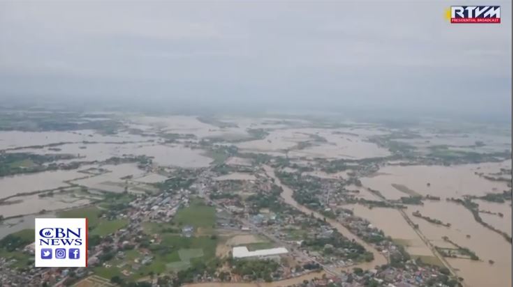
Australia, famous for its pristine beaches and wildlife, has been fighting bushfires since September, with fires killing 29 people and millions of animals, and destroying more than 2,500 homes while razing an area roughly a third the size of Germany.

Victoria, New South Wales and Queensland, three of the states most affected by drought and bushfires welcomed this week’s drenching rain, with fire services saying it would not extinguish all the blazes, but would greatly aid containment.

“Our fingers are crossed that this continues over the coming days,” New South Wales fire services said on Twitter on Friday.

Severe storms are forecast to continue in many fire-stricken regions of New South Wales and Queensland, including areas that have not seen heavy falls for years, weather officials in New South Wales said, slightly easing a three-year drought.

“The recent rain has just been absolutely fantastic,” said cattle farmer Sam White near the northern town of Guyra in New South Wales.

“It’s producing significant amounts of runoff, which is what we need, and it’s getting into our dams.”

While the wet weather brings relief to fire fighters and drought-hit farmers, it also comes with dangers, such as flash flooding and falling trees. One wildlife park had to rescue koalas from floodwaters and beat back crocodiles with brooms.

The heavy downpours have helped to clean smoky air in Australia, but Sydney, Canberra and Melbourne remained in the world’s top 100 polluted cities on Friday, a pollution ranking by AirVisual showed.

Melbourne, shrouded this week in thick smoke that disrupted the Australian Open qualifying matches and other competitions, is forecast to again be blanketed by unhealthy air over the weekend, before the Grand Slam begins in earnest on Monday.

But fears the smoke would return on Saturday for the final round of qualifying eased on Friday, when the Environmental Protection Agency forecast air quality in the Melbourne area would be “moderate” rather than “very poor”.

The smoke haze plaguing Australia’s major cities for weeks has been tracked by NASA circumnavigating the globe and the space agency’s satellites showed on Thursday there was also a large concentration of lower smoke over the Pacific Ocean.

Here are key events in the bushfire crisis:

* Early on Friday, 82 fires were burning across New South Wales, 30 uncontained, and several in Victoria, fire authorities said.

* An emergency evacuation order was issued for parts of Victoria’s northeast, with an out-of-control bushfire threatening the Buffalo River Valley.

* Firefighters, family and the community of Holbrook in New South Wales bade farewell to Samuel McPaul, a 28-year-old volunteer who died in December while fighting a massive and fast-moving blaze.

* Australia will have to wait until March for rains heavy enough to bring sustained relief from dry weather that has fuelled the bushfires, the weather bureau said.

* Top tourism body estimates the bushfire crisis has cost the Australian industry almost A$1 billion ($690 million). [L4N29L069]

* Players’ complaints about pollution blighted qualifying rounds of the Australian Open in Melbourne, the year’s first tennis Grand Slam.


(Reporting by Lidia Kelly; Editing by Michael Perry and Clarence Fernandez)

Death toll from Kenya landslides rises to 56 as heavy rains lash country’s north west

People walk in the mud after heavy rains caused landslides in the village of Parua, West Pokot County, Kenya November 23, 2019. REUTERS/Moses Lokeris


MOMBASA (Reuters) – The death toll from landslides in northwestern Kenya triggered on Saturday by unusually heavy rains has risen to at least 56 people, a local official said.

The downpour began on Friday in West Pokot County, which borders Uganda, and worsened overnight, causing flooding and mudslides that swept away four bridges and left villages inaccessible by road.

Samuel Poghisio, a senator from the county, told Reuters by phone on Sunday that 56 people were confirmed dead and an unknown number were missing. By Saturday afternoon, local officials had reported 36 dead.

“Rescue operations are frustrated by more rain and fog,” Poghisio wrote in a text message, adding that police helicopters were struggling to reach the flooded areas.

Kenya’s president on Saturday deployed rescue personnel from agencies including the army and the police to try and prevent the “further loss of lives”.

Houses are seen covered by mud after heavy rains caused landslides in the village of Parua, West Pokot County, Kenya November 23, 2019. REUTERS/Moses Lokeris

Researchers have warned that warming oceans are causing unpredictable weather patterns in East Africa.

Heavy rains and floods have killed more than 50 people and forced hundreds of thousands of people from their homes in the region since October, aid groups said earlier this month.

Kenya is experiencing a heavier than usual rainy season, the Kenya Meteorological Department said in early November.

(Reporting by Joseph Akwiri; Writing by Maggie Fick; Editing by Kirsten Donovan)

Torrential Imelda rains kill 2, flood homes, snarl travel around Houston

HOUSTON (Reuters) – Tropical Storm Imelda dumped torrential rains over the Houston-area, killing at least two people, while rescuers in boats pulled hundreds from flooded cars, the airport temporarily halted flights and tens of thousands of people lost power.

Heavy rains had abated by Thursday evening, although flash flood watches remained in effect through Friday morning and rescuers were still working to reach stranded motorists and those trapped in homes late into the night as floodwaters were slow to drain off.

The National Hurricane Center said in a late Thursday bulletin that up to 45 inches of rain will have fallen in some areas by the time the storm blows off on Friday afternoon.

Ed Gonzalez, sheriff for Harris County, which includes Houston, confirmed the second death from the storm.

He tweeted on Thursday that he was at the scene where first-responders tried to save a man who had driven his white van headlong into deep waters.

“The water level was about 8′ (8 feet) high,” Gonzalez wrote, describing the incident. “The driver paused briefly, then accelerated into it the water, causing his van to go under.”

Gonzalez said the man driving the van was pulled from the vehicle after some 20 minutes underwater and was later pronounced dead at a hospital.

The other victim of the storm was electrocuted southeast of Houston while trying to move his horse to safety, according to a statement on the Facebook page of the Jefferson County Sheriff’s Department. No other details were provided.

George Bush Intercontinental Airport halted all flights for about two hours, and Governor Greg Abbott declared a state of disaster covering more than a dozen counties.

Hundreds of motorists were stranded in their vehicles as some of Houston’s main roadways flooded, submerging cars. Firefighters, police and ordinary citizens were out in boats and all-terrain vehicles to pick up people trapped in their homes by the rising waters.

The storm knocked out power to around 100,000 people in Houston and southeast Texas, according to reports from energy companies, while work at oil refineries in the area was slowed or halted.

Houston Mayor Sylvester Turner said the city was better prepared to rescue stranded residents and deal with flooding than when Hurricane Harvey hit in 2017, leading to dozens of deaths in Houston and billions of dollars in damage.

The small town of Winnie, about 60 miles (100 km) east of Houston, was also badly hit. Officials there evacuated Riceland Hospital and tried to rescue people marooned in their vehicles after roads turned into lakes.

Parts of Interstate 10, a major east-west highway, were closed near Winnie.

Imelda made landfall as a tropical storm near Freeport, Texas, on Tuesday.

(Reporting by Gary McWilliams in Houston, Jonathan Allen in New York, Brad Brooks in Austin, Texas, and Liz Hampton in Denver; Editing by Scott Malone, David Gregorio and Tom Hogue)