Californians see Wind, Rain and Mudslides after latest storms pass through

Luke 21:25 ““And there will be signs in sun and moon and stars, and on the earth distress of nations in perplexity because of the roaring of the sea and the waves

Important Takeaways:

  • California reeling from mudslides, wind damage after latest atmospheric river to pummel state
  • Crosswinds blew over trucks and trailers on Bay Area bridges. Authorities closed the Golden Gate Bridge and the Richmond San Rafael Bridge to high-profile vehicles. San Francisco International Airport issued a ground stop for a time because of the extreme gusts.
  • In the Santa Cruz area, two cars were struck by a falling tree as they traveled along busy Highway 1.
  • Gusts reached 80-90 mph in some of the Bay Area foothills, with Loma Prieta registering a gust of 97 mph. Farther inland, Sacramento reported a 60-mph gust.
  • At the height of the storm, some 373,000 customers were without power in California as trees and power lines succumbed to the high winds
  • In Placer County near the Sierra Nevada, a massive landslide crashed into a home in Colfax, leaving significant mud-covered damage but no injuries.
  • Orange County emergency crews evacuated an apartment building when the cliff holding up the rear of the building collapsed onto the trail below.
  • As night approached, heavier rains spread south into the Los Angeles area, setting eight daily rainfall records across Southern California… a daily record that had stood for 97 years.

Read the original article by clicking here.

Hurricane Fiona dumps 30” of rain causing power outages, mudslides, and flooding

  • Catastrophic flooding in Puerto Rico as Hurricane Fiona dumps nearly 30 inches of rain
  • Hurricane Fiona struck Puerto Rico’s southwest coast on Sunday, bringing destructive flooding, mudslides and an island-wide power blackout one day after leaving one dead in the Leeward Islands. The storm went on to make a second landfall in the Dominican Republic very early on Monday morning.
  • Fiona was a Category 1 hurricane with maximum sustained winds of 85 mph, when it made landfall.
  • LUMA Energy, the private company that handles the transmission and distribution of electricity in Puerto Rico, stated that full power restoration could take days “due to the magnitude and scope of the blackout.”
  • More than 778,000 residents in Puerto Rico were without drinking water as of Monday, El Nuevodia, a local news source reported.

Read the original article by clicking here.

Western Virginia, Kentucky, and southern West Virginia hit hard by flooding and landslides

Revelation 16:9 “They were scorched by the fierce heat, and they cursed the name of God who had power over these plagues. They did not repent and give him glory.”

Important Takeaways:

  • Flooding in Central Appalachia Kills at Least 8 in Kentucky
  • Kentucky Gov. Andy Beshear asked for prayers as the region braced for more rain.
  • “In a word, this event is devastating,” Beshear said Thursday. “And I do believe it will end up being one of the most significant, deadly floods that we have had in Kentucky in at least a very long time.”
  • Beshear warned that property damage in Kentucky would be extensive and opened an online portal for donations that would go to residents affected by the flooding.
  • Meanwhile, dangerous conditions and continued rainfall hampered rescue efforts Thursday, the governor said.
  • Flash flooding and mudslides were reported across the mountainous region of eastern Kentucky, western Virginia and southern West Virginia, where thunderstorms dumped several inches of rain over the past few days.
  • us reported more than 33,000 customers without electricity in eastern Kentucky, West Virginia and Virginia, with the bulk of the outages in Kentucky.
  • Jim Justice declared a state of emergency for six counties in West Virginia after severe thunderstorms this week caused significant local flooding, downed trees, power outages and blocked roads.
  • In West Virginia’s Greenbrier County, firefighters pulled people from flooded homes, and five campers who got stranded by high water in Nicholas County were rescued

Read the original article by clicking here.

A months’ worth of rain has brought flooding and mudslides to Petropolis Brazil

Important Takeaways:

  • Death toll in Brazil’s Petropolis mudslides, floods hits 176; more than 110 missing
  • Downpours in the colonial-era city exceeded the average for the entire month of February causing mudslides that flooded streets, destroyed houses, washed away cars and buses, and left gashes hundreds of yards wide on the region’s mountainsides.
  • rainfall was the heaviest registered since 1932 in Petropolis, a tourist destination in the hills of Rio de Janeiro state, popularly known as the “Imperial City”
  • Responding to the disaster, several Brazilian states sent reinforcements to help searching for missing people and cleaning up the debris alongside Rio’s fire department.

Read the original article by clicking here.

Canada’s flood-hit British Columbia braces for more heavy rain

OTTAWA (Reuters) – The Canadian province of British Columbia is facing more heavy rains as it tries to recover from massive floods and mudslides, Public Safety Minister Mike Farnworth told reporters on Tuesday.

Farnworth said crews were working to shore up dikes and dams, adding some roads would be closed protectively.

Flooding earlier this month in Canada’s westernmost province triggered landslides that killed four people, cut off rail access to Vancouver, Canada’s largest port, and caused billions of dollars of damage.

“In some areas … this could be the most intense storm yet,” Farnworth said. “The cumulative effect of this succession of storms will be – and continues to be – a major challenge.”

Officials said parts of the province could expect up to 4.7 inches (12 cm) of rain in less than 36 hours starting later on Wednesday.

The province on Monday extended a state of emergency through Dec. 14. That limits vehicles deemed “non-essential” by the government to 7.9 gallons (30 litres) of fuel.

(Reporting by David Ljunggren; Editing by Jonathan Oatis and Peter Cooney)

Receding waters help flood-hit Canadian town to avoid disaster

By Jesse Winter

ABBOTSFORD, British Columbia (Reuters) – Receding floodwaters helped a Canadian town avoid disaster on Thursday as the province of British Columbia faced up to what one expert said was the costliest natural disaster in the country’s history.

More than 18,000 people were stranded after a series of floods and mudslides destroyed roads, houses and bridges while blocking off entire towns and cutting access to the country’s largest port.

Premier John Horgan declared a state of emergency on Wednesday and said the death toll would most likely rise from the one confirmed fatality.

At one point the city of Abbotsford, to the east of Vancouver, feared the waters would overwhelm their pumping station and force the evacuation of all 160,000 residents.

But late on Wednesday, mayor Henry Braun said the situation was improving.

“Throughout the day water levels have continued to abate,” he told reporters. “There’s a recovery coming. We are still focusing … on getting out people and keeping them safe, but the recovery is just around the corner.”

Residents in Merritt, which has been cut off for almost four days, told CTV on Thursday that the waters there were also starting to drop.

Late on Wednesday, emergency workers were able to temporarily open a narrow road to Hope, which had also been cut off since Sunday. Once people had left, the road would be closed again, the provincial government said.

One of those who managed to get out was Simon Fraser University professor Enda Brophy.

“If there’s anything to be learned from this experience, it’s we are woefully underprepared for the environmental disasters that are on the way. We can barely cope with the ones that we have,” he said by phone.

When the waters do recede, the province can start to look at the massive task of repairing smashed infrastructure.

“Easily the costliest natural disaster in Canadian history. Won’t even be close,” tweeted University of Calgary economics professor Blake Shaffer, a specialist in climate policy.

The most expensive natural calamity in Canada so far was the wildfires that hit Alberta’s oil-producing region of Fort McMurray in May 2016. Insured losses cost C$3.6 billion.

The federal government in Ottawa is promising to send hundreds of air force personnel to British Columbia, and says thousands more are on standby.

(Reporting by David Ljunggren in Ottawa, Ismail Shakhil in Bengaluru and Anna Mehler Paperny in Toronto; writing by David Ljunggren; editing by Jonathan Oatis)

Hurricane Rick loses steam as it moves further inland Mexico

MEXICO CITY (Reuters) -Hurricane Rick’s strong winds lost some steam as the storm moved further inland on Monday, though its heavy rains still had the potential to trigger flash flooding and mudslides, the U.S. National Hurricane Center (NHC) and local authorities said.

Rick was packing maximum sustained winds of 80 miles per hour (130 km/h), down from 105 mph, and was some 40 miles (65 kilometers) north of the port of Lazaro Cardenas in Michoacán state as of 10:00 A.M. local time (1500 GMT), the Miami-based NHC said in a public advisory.

The storm came ashore on Mexico’s Pacific coast earlier in the day.

“Rapid weakening is expected today while Rick continues to move over land, and Rick is forecast to dissipate over the mountainous terrain of southern Mexico tonight or Tuesday,” the NHC said.

Rick is forecast to move farther inland over southern Mexico throughout Monday and possibly into Tuesday, and is expected to produce 5 to 10 inches of rain, with isolated storm total amounts of 20 inches across parts of the Mexican states of Guerrero and Michoacán through Tuesday.

The heavy rains “will likely produce flash flooding and mudslides,” the NHC said.

The heavy rains may trigger landslides, raise the water levels of rivers and streams, and cause flooding in low-lying areas, Mexico’s National Water Commission, CONAGUA, said in a statement.

CONAGUA urged residents in the southern parts of those states to heed the civil protection agency warning to stay indoors as of Sunday evening.

Guerrero’s education ministry said classes in the coastal area would be suspended on Monday, warning of intense rain, strong gusts of wind and high waves in the Costa Grande region.

Officials in Guerrero and Michoacán as well as the coastal states of Colima, Jalisco and Nayarit were opening shelters in areas expected to get downpours, a government official told Televisa News.

(Reporting by Anthony Esposito; editing by Barbara Lewis and Chizu Nomiyama)

Disaster hacks: South American cities harness tech and nature to tackle flooding

By Anastasia Moloney

BOGOTA (Thomson Reuters Foundation) – Hit with ever-more-frequent torrential rain that triggers worsening flooding and mudslides most years, Rio de Janeiro is looking to an unusual gathering for answers: a hackathon.

Starting Saturday, teams of university students, tech start-up leaders, software developers and computer engineers will try to come up with innovative ways to help the seaside Brazilian city limit its losses as climate change brings wilder weather.

Tech experts at the city hall-led event hope to, for instance, come up with new ways to leverage data from GPS systems already used in the city’s buses to allow emergency services to better understand and monitor floods in real time.

“We know we have problems of floods and heavy rains, and we see an opportunity to use GPS to know where the flooding and landslide incidents are,” said Simone Silva, a mobility advisor at city hall and one of the organizers.

Right now, “at the very local level, we don’t know exactly what happens,” she told the Thomson Reuters Foundation.

RISING URBANIZATION

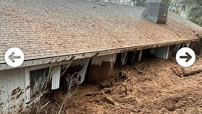
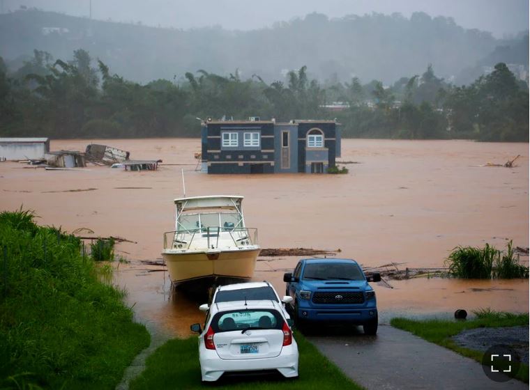
Around Latin America, tens of millions of people are at risk from worsening flooding linked to climate change, many of them living in urban slums often built along rivers or on mountain slopes prone to landslides.

About 80% of Latin America’s people live in the region’s urban areas, according to the United Nations.

But across the region, cities are working to cut the risks, harnessing technology, better data and insights from affected communities to come up with new ways to keep people safe.

Flooding is clearly seen as one of the most severe threats. Of 530 cities worldwide that reported their climate hazards in 2018 to CDP, a London-based international environmental non-profit, 71% said floods were their top worry.

Extreme heat came next, at 61%, followed by drought at 36%, according to the study, published last month.

But over half of cities have not carried out risk assessments to map which areas, residents and businesses are under threat from extreme weather, the study found.

“We have seen that cities that take vulnerability assessments, they take six times as many actions to adapt as cities that haven’t done them,” said Kyra Appleby, who heads the CDP’s cities, states and regions team.

Geographic information system (GIS) technology that allows data about hazards and climate risks to be overlayed with existing maps of cities has made it easier for authorities to do risk assessments, she added.

That and other technologies are among the measures being used in a range of cities around Latin America to deal with worsening economic and human losses from floods.

In recent decades, Rio de Janeiro, for instance, has put in place early warning systems to help evacuate people ahead of threats, mapped of floodplain areas, built shelters and conducted emergency drills in slum areas, Appleby said.

The city also has installed cameras to monitor street flooding and set up social media alert systems.

Other cities are introducing digital sensors to try to cut risks. Argentina’s capital, Buenos Aires, is developing a network of sensors to monitor rainfall and feed back data in real time to the city’s central control centre.

Ensuring climate change adaptation measures are included in all urban planning is crucial, Appleby said, noting that the city of Belo Horizonte, in Brazil’s Minas Gerais state, is one of those leading the way.

“It’s in the process of creating a new masterplan for the city and they are integrating all their adaption measures into their masterplan. That is really ahead of the curve,” she said.

To be effective, climate adaption plans must include the input of local communities, according to Anjali Mahendra, head of research at the World Resources Institute Ross Center for Sustainable Cities.

“Latin American cities are particularly good with involving communities,” she said.

That’s largely because early urbanization in the region means cities have had longer experience working with informal settlements and other disadvantaged communities, she said.

African and South Asian cities, facing rapid urbanization are “starting to learn from some Latin American cities,” Mahendra said.

Colombia’s second city of Medellin and Ecuador’s capital Quito – which has a climate change panel that includes youth, women and indigenous groups – in particular have worked hard to include local communities in decisions about urban planning and climate risks, said Mahendra.

USING NATURE

To tackle growing flood threats, more investment also is needed in “nature-based solutions” – such as expanding green areas to absorb floodwaters, said Pedro Ribeiro, head of the Urban Flooding Network at C40, a group of cities pushing climate action.

Creating green buffer areas to stem urban sprawl and protecting and restoring degraded ecosystems around cities, including forests, watersheds, grasslands and wetlands, can help slow the movement of water and avoid flooding, he said.

“It’s easier to recover ecosystems that were in the city before building .. and the results are better” than trying to establish wholly new anti-flooding systems, Ribeiro said.

(Reporting by Anastasia Moloney @anastasiabogota, Editing by XXXX. Please credit the Thomson Reuters Foundation, the charitable arm of Thomson Reuters, that covers humanitarian news, women’s and LGBT+ rights, human trafficking, property rights, and climate change. Visit http://news.trust.org)

Death toll in South Africa rains approaching 70, official says

Family members speak to a police officer after one of their family member's body was recovered from under the mud after heavy rains caused by flooding in Mariannhill near Durban, South Africa, April 25, 2019. REUTERS/Rogan Ward

DURBAN/JOHANNESBURG (Reuters) – Almost 70 people have been killed in South Africa after torrential rains along the eastern coast, an official said on Thursday, and rescuers are still recovering bodies.

KwaZulu-Natal province, where most of the deaths occurred after the downpours led to flooding and mudslides, has heavy rain every year, but they rarely kill so many people in such a short space of time.

A wreckage of a vehicle remains after a body was recovered from under the mud after heavy rains caused by flooding in Marianhill near Durban, South Africa, April 25, 2019. REUTERS/Rogan Ward

A wreckage of a vehicle remains after a body was recovered from under the mud after heavy rains caused by flooding in Marianhill near Durban, South Africa, April 25, 2019. REUTERS/Rogan Ward

The number of people killed was “approaching 70”, Lennox Mabaso, a spokesman for the provincial Cooperative Governance and Traditional Affairs department, said by phone.

“I don’t recall that in history,” he said, attributing the severity of the storm and its impact on the population to climate change.

A Reuters witness saw rescuers come to collect the body of a woman who had been dug out of the mud by locals. Mabaso said a more precise death toll would be given later on Thursday.

Eyewitnesses recounted on Wednesday how flood waters and mudslides crashed through houses, many with people inside, and destroyed roads and other infrastructure.

The rains carved chunks out of hills and roads in the region, with cars, tin roofs and other rubble swept into the deep muddy trenches left behind.

In other places, people buried their dead on muddy hillsides churned up by the storm, marking their resting place with simple wooden crosses.

Vanetia Phakula, a senior forecaster at the South African Weather Service, said the storm was not currently seen as unusual, though the level of rainfall might have been higher than normal.

Over 100 millimeters of rain was recorded as falling at numerous stations within the area between Monday morning and Tuesday, she said.

Phakula said the high death toll could instead be explained by the flooding and mudslides occurring in more highly populated areas.

“Hence the death toll is what it is today,” she said.

While more rain was expected on Thursday it was not expected to be heavy, and the service was forecasting dry weather in most areas by Friday, she added.

(Reporting by Rogan Ward in Durban and Emma Rumney in Johannesburg; Editing by Hugh Lawson)

‘Pineapple Express’ storm douses California with rain, snow

Snow capped mountains are seen behind the downtown Los Angeles skyline, California, U.S., February 12, 2019. REUTERS/Lucy Nicholson

By Andrew Hay

(Reuters) – A Pacific storm system known as the “Pineapple Express” threatened to dump up to 8 inches of rain and 8 feet of snow on areas of California, raising risks of flooding and mudslides, meteorologists said on Wednesday.

“The (Pineapple) Express is no joke,” said Bob Oravec, meteorologist with the National Weather Service’s Weather Prediction Center in College Park, Maryland of the strongest weather system of the season.

The weather system, also known as an atmospheric river, gets its name from the flow of moisture that periodically heads east from waters adjacent to the Hawaiian Islands to soak the U.S. West Coast. It blanketed parts of Hawaii with snow over the weekend and is expected to drench California.

The San Francisco Bay area could be hit by flash flooding and falling trees as saturated ground gets up to 8 inches more rain and strong winds blow in, the weather service said.

“We’re talking 3 to 5 inches of rain in San Francisco and coastal areas in just the next 24 hours, and more on into Friday,” Oravec said.

To the northeast in the Sierra Nevada Mountains, passes could see between 80 and 100 inches (approximately 7 to 8 feet) of snow through Friday.

Valley areas face flood watches over fears the relatively warm Pineapple Express system could initially drench areas as high as Lake Tahoe with rain, melting snow and swelling rivers.

WILDFIRE BURN AREAS

The Central and Southern California coast can expect flash flooding and possible mudslides near recent wildfire burn areas, the NWS reported.

Oravec said that the problem is not just the amount of rain, but the fact that it will hit in a short amount of time.

“It’s going to be heavy and fast,” he said. “Debris flows and mudslides are a risk in any area scorched by the wildfires. There’s little to no vegetation to slow that water down.”

Up to 2 inches of rain was expected in the Los Angeles area between Tuesday evening and Thursday morning, the weather service said.

A string of winter storms has swelled snowpack in California to above-average levels, delighting farmers in need of water and skiers in search of powder.

(Reporting by Andrew Hay, additional reporting by Rich McKay, editing by Louise Heavens)