By Ernest Scheyder
WILMINGTON, N.C. (Reuters) – Hurricane Florence, on track to become the first Category 4 storm to make a direct hit on North Carolina in six decades, howled closer to shore on Tuesday, threatening to unleash deadly pounding surf, days of torrential rain and severe flooding.

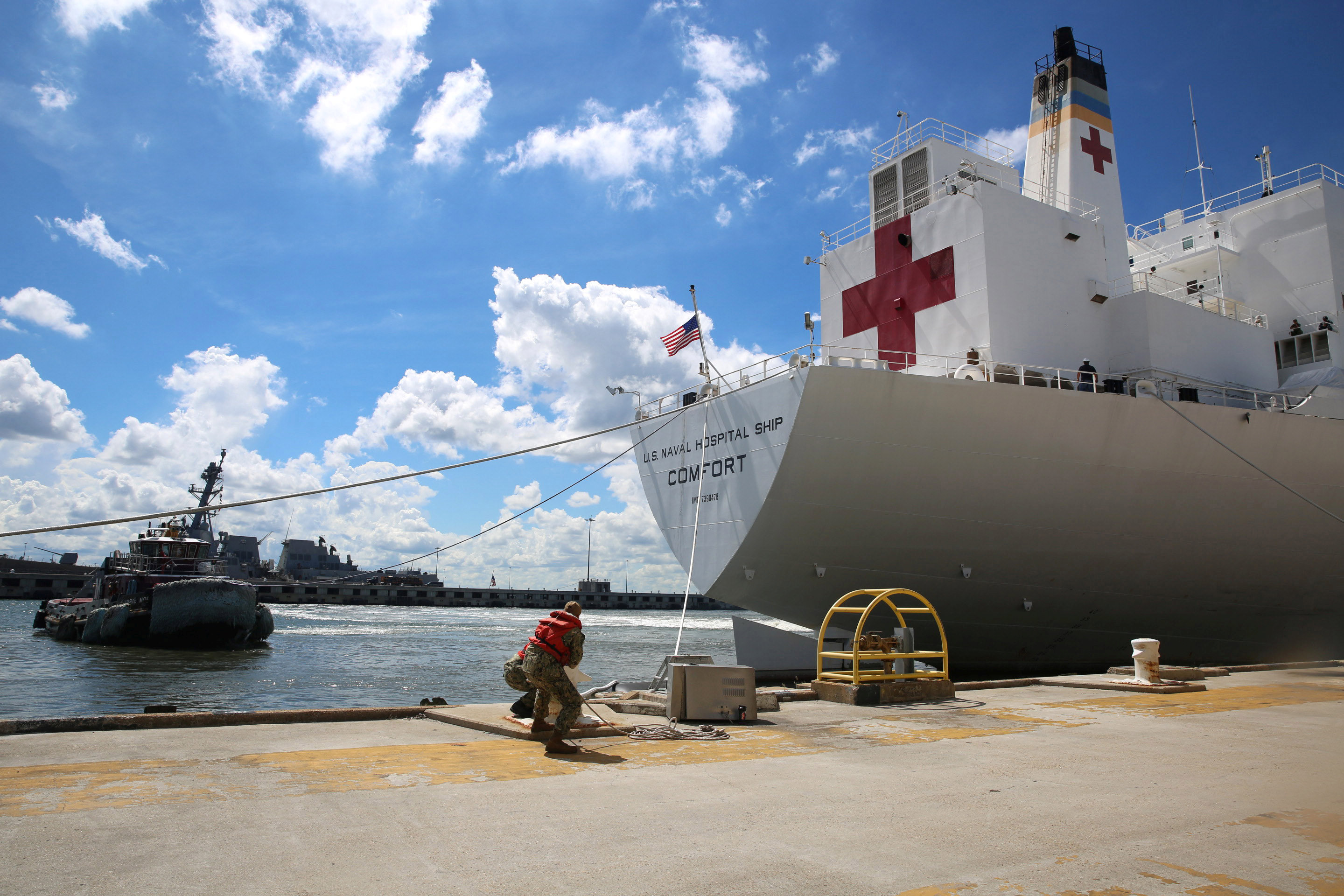
Sailors cast off mooring lines to the Command hospital ship USNS Comfort as the ship evacuates Naval Station Norfolk in preparation for Hurricane Florence in Norfolk, Virginia, U.S., September 11, 2018. Jennifer Hunt/US Navy/Handout via REUTERS
Fierce winds and massive waves are expected to lash the coasts of North and South Carolina and Virginia even before Florence makes landfall by early Friday, bringing a storm surge as much as 13 feet (4 meters), the National Hurricane Center in Miami warned. Catastrophic floods could follow if the storm stalls inland, it said.
Although Florence was still days from arrival, authorities took extraordinary measures to move people out of harm’s way. More than 1 million residents have been ordered to evacuate from the coastline of the three states, while university campuses, schools, and factories were being shuttered.
The U.S. Coast Guard closed ports in Wilmington and Morehead City, North Carolina and Hampton Roads, Virginia to inbound vessels greater than 500 tons and was requiring vessels of that size to leave if they did not have permission to be in the ports.
Packing maximum sustained winds of 140 miles per hour (225 km per hour), the storm ranked as a Category 4 on the five-step Saffir-Simpson hurricane scale and was expected to grow stronger and larger over the next few days, the NHC said.
“This storm is a monster,” North Carolina Governor Roy Cooper said. “Even if you’ve ridden out storms before, this one is different. Don’t bet your life on riding out a monster.”
He cited forecasts showing Florence was likely to stall over North Carolina, “bringing days and days of rain.”
To hasten evacuations from coastal South Carolina, officials reversed the flow of traffic on some highways so all major roads led away from shore.
Kathleen O’Neal, a resident of Ocracoke Island in North Carolina’s Barrier Islands, said she, her husband and son would ride out the storm. “A lot of local people are staying,” she said of the island, which is reachable only by ferry or plane.

John Muchmore helps to lay sandbags at the Afterdeck condos ahead of the arrival of Hurricane Florence in Garden City Beach, South Carolina, U.S., September 11, 2018. REUTERS/Randall Hill
LONG-TERM POWER OUTAGES POSSIBLE
Maps of Florence’s trajectory showed its center most likely to strike the southern coast of North Carolina. The last Category 4 hurricane to plow directly into North Carolina was Hazel in 1954, a devastating storm that killed 19 people and destroyed some 15,000 homes.
NHC forecasts showed the effects of Florence would be widely felt, with tropical storm-force winds extending nearly 300 miles across three states. A hurricane warning was posted for most of the Carolina coast north to the Virginia border.
In addition to wind-driven storm surges of seawater, Florence could dump up to 35 inches (89 cm) in some spots as it moves inland, forecasters said.
Communities in Florence’s path could lose electricity for weeks due to downed power lines and flooded equipment, Federal Emergency Management Agency (FEMA) Administrator Brock Long said.
Utilities deployed crews and gear in advance, with workers en route to the region from at least 15 states, according to trade group, the Edison Electric Institute.
Crews also prepared 16 nuclear reactors in the three-state region for the storm. One power station, Duke Energy Corp’s Brunswick plant, the closest to the area where landfall is forecast, faced a likely shutdown as a precaution. Shutdowns also were possible at two more plants in the path of predicted hurricane-force winds.
The American Red Cross said more than 700 workers were headed to the region while shelters were set up to house those unable to flee. A hospital in Hampton, Virginia, was transferring patients to safer places.
U.S. President Donald Trump on Tuesday signed declarations of emergency for North Carolina, South Carolina and Virginia, freeing up federal resources for storm response.
“We are sparing no expense. We are totally prepared,” Trump said at the White House.
Trump faced severe criticism for his administration’s response to Hurricane Maria last year in Puerto Rico. Some 3,000 people died in the aftermath of that storm.

U.S. President Donald Trump holds an Oval Office meeting on hurricane preparations as FEMA Administrator Brock Long points to the potential track of Hurricane Florence on a graphic at the White House in Washington, U.S., September 11, 2018. REUTERS/Leah Millis
COMMERCIAL OPERATIONS
Days before its arrival, Florence was already disrupting commercial operations.
Boeing Co suspended work on Tuesday at the South Carolina plant where it assembles 787 widebody jetliners, and a Volvo automobile plant in South Carolina’s evacuation zone was also closed, company officials said.
Smithfield Foods Inc [SFII.UL] said it would shut down the world’s largest hog-slaughtering facility in Tar Heel, North Carolina, on Thursday and Friday due to the hurricane.
Residents prepared by boarding up their homes and stocking up on food, water and other essentials, stripping grocery store shelves of merchandise. Many gasoline stations were running low on fuel.
“I’m scared we’ll get 30 inches or more of rain,” said Carol Trojniar, 69, a longtime Wilmington resident and retired real estate agent who has never experienced a Category 4 hurricane. “What is flooding going to do to our home, our city?”
Trojniar said she and her husband were packing up belongings and plan to stack sandbags around their single-floor home in Wilmington’s eerily named Landfall neighborhood near the ocean before checking into a hotel to ride out the storm, with plenty of wine.
“Where else can we go? If we try to leave, we’ll just get stuck in the rain,” she said.
(Reporting by Ernest Scheyder; Additional reporting by Anna Driver in Holden Beach, North Carolina, Gene Cherry in Raleigh, North Carolina, Liz Hampton in Houston, Susan Heavey in Washington, Bernie Woodall in Fort Lauderdale, Florida, Scott DiSavino and Alden Bentley in New York, Nichola Groom and Alex Dobzinskis in Los Angeles and Brendan O’Brien in Milwaukee; Writing by Nick Zieminski, Bill Trott and Steve Gorman; Editing by Bill Tarrant, Lisa Shumaker and Michael Perry)