As Hurricane Nicole weakens as much as 8” of rain expected for northern FL

Revelation 16:9 “They were scorched by the fierce heat, and they cursed the name of God who had power over these plagues. They did not repent and give him glory.”

Important Takeaways:

  • At least 2 reported dead as Nicole weakens after striking Florida’s east coast as the first US hurricane in November in nearly 40 years
  • A tornado threat, plus powerful wind and heavy rain, are expected to continue Thursday in parts of Florida, Georgia and South Carolina after Nicole
  • Meanwhile, communities are assessing the damage.
  • At least 49 beachfront buildings including 24 hotels and condos have been deemed “unsafe” following Hurricane Nicole in Volusia County
  • More than 237,000 homes and businesses in Florida were without power late Thursday, according to PowerOutage.us.
  • Nicole’s landfall Thursday was the latest in a calendar year a hurricane has ever struck Florida’s Atlantic coast. It broke the record set by the Yankee Hurricane, which hit Florida’s east coast on November 4, 1935.

Read the original article by clicking here.

Strange Weather: Southern California gets the closest tropical storm since ’97

Revelation 16:9 “They were scorched by the fierce heat, and they cursed the name of God who had power over these plagues. They did not repent and give him glory.”

Important Takeaways:

  • Eye-popping satellite photo shows Tropical Storm Kay over Southern California
  • It was an unusual sight at the tail end of one of California’s weirdest weather weeks ever: a massive tropical storm system swirling over the Southland.
  • Though Kay never made landfall in the state, “it was certainly closer than anything we’ve ever had before that I can remember,” said Mike Wofford, a meteorologist with the National Weather Service in Oxnard.
  • Brandt Maxwell, a meteorologist with the weather service in San Diego, said “it’s not outlandish to say that the impacts covered a 1,000-mile-wide area.”
  • Though the storm was not nearly enough to end the megadrought plaguing the state, it did help dampen the raging Fairview fire in Riverside County, officials said.
  • In San Diego County, the storm dropped more than 5 inches of rain in Mt. Laguna
  • The Los Angeles area saw less precipitation overall — with most areas recording 1.5 inches or less by the end of the weekend — but did see some daily records, including 0.32 inches in Sandberg

Read the original article by clicking here.

Geoengineering now a mainstream topic when China is doing it

Revelation 16:9 “They were scorched by the fierce heat, and they cursed the name of God who had power over these plagues. They did not repent and give him glory.”

Important Takeaways:

  • China Has Started Geoengineering Rain Over Extreme Heat and Drought
  • China is reportedly planning to use cloud-seeding technology to force it to rain in an attempt to alleviate the drought conditions plaguing the Yangtze River basin—amid hot temperatures that have affected crop growth and forced the shutdown of industries in order to conserve energy.
  • Cloud seeding can cause it to rain artificially by sending airplanes into the clouds and releasing silver iodide. Geoengineering such as this may be the future in order to combat the effects of climate change on the planet, scientists say.
  • This cloud-seeding approach works by improving a cloud’s ability to produce rain by adding a nucleation point for raindrops to form around. Silver iodide, the compound sprayed into the clouds, exists naturally in the environment at low concentrations

Read the original article by clicking here.

Dallas Texas gets 9” of rain in a single night. A typical summer gets 8.2”

Revelations 2:5 “Remember therefore from where you have fallen; repent, and do the works you did at first. If not, I will come to you and remove your lampstand from its place, unless you repent.

Important Takeaways:

  • At least one dead after Dallas area hit by 1-in-1,000-year flood
  • In Mesquite, southeast of Dallas, a body was recovered Monday afternoon from a vehicle in a creek.
  • Elsewhere, authorities conducted water rescues and evacuated residents from flooded areas; cars remained abandoned, some parked on the sides of interstates, either flooded or damaged in crashes; numerous highway ramps and lanes were shut down. At the interchange of Interstates 30, 45 and 75 — a trouble spot on good days — flooding had traffic down to a trickle in one lane.
  • In some isolated areas, the rainfall totals would be considered a 1-in-1,000-year flood — a remarkable reversal given the dramatic drought that Dallas had faced for months. Several rainfall gauges recorded more than 10 inches.
  • The downpour marked the latest such flood in the past few weeks across the United States. In one week alone, three 1-in-1,000-year rain events occurred, inundating St. Louis, eastern Kentucky and southeastern Illinois.

Read the original article by clicking here.

Two Winter Storms to Hit Millions

1 Timothy 5:8 “But if anyone does not provide for his relatives, and especially for members of his household, he has denied the faith and is worse than an unbeliever.

Important Takeaways:

  • One-two punch of storms to bring rounds of rain, snow and storms to millions
  • A blast of arctic cold in the West and into the Northern Plains was also expected to be the longest-duration cold outbreak of the winter season so far.
  • Snow will be heaviest across parts of Minnesota as well northern Wisconsin and northern Michigan. Additional snowfall of up to 6 inches will be possible, bringing storm totals of 1 to 2 feet in some areas. The snow, combined with wind gusts up to 30 mph, will lead to dangerous travel conditions.

Read the original article by clicking here.

Remnants of Hurricane Laura drench Arkansas as storm heads east

(Reuters) – The remnants of Hurricane Laura were dousing Arkansas on Friday morning and due to bring rain to the East Coast over the weekend.

Now a tropical depression, Laura had proved less damaging than feared, despite arriving in Louisiana this week as one of the most powerful hurricanes recorded in the United States.

The storm killed at least six people in Louisiana, including four who were killed when trees fell into homes, damaged buildings in Louisiana and Texas and knocked out power for hundreds of thousands of residents.

U.S. President Donald Trump is expected to head to the Gulf Coast over the weekend to survey the damage.

The storm was forecast to drop heavy rain over Arkansas, Mississippi, Alabama, Tennessee, Missouri and Kentucky as it headed out to the East Coast, the National Weather Service said.

At its peak upon making landfall on Thursday morning, Laura had maximum sustained winds of 150 miles per hour (241 km per hour), faster than even Hurricane Katrina, which sparked deadly levee breaches in New Orleans in 2005 after arriving with wind speeds of 125 mph.

What would have been a dangerous 20-foot (6-m) storm surge that forecasters had predicted could move 40 miles (64 km) inland was avoided when Laura tacked east just before landfall, Louisiana Governor John Bel Edwards said. That meant a mighty gush of water was not fully pushed up the Calcasieu Ship Channel, which would have given the storm surge an easy path far inland.

(Reporting by Jonathan Allen in New York; Editing by Marguerita Choy)

Hurricane Laura slams southwestern Louisiana, but less damage than forecast

By Elijah Nouvelage and Ernest Scheyder

LAKE CHARLES, La. (Reuters) – Hurricane Laura ripped through southwestern Louisiana on Thursday, destroying buildings in towns across the southwestern corner of the state and killing a 14-year-old girl after making landfall as one of the most powerful storms to hit the area.

Still, the damage Laura has inflicted so far is far less than what forecasters predicted.

The hurricane’s first reported U.S. fatality was the teenage girl in Leesville, Louisiana, who died when a tree fell on her house, a spokeswoman for Governor John Bel Edwards said.

“We do expect that there could be more fatalities,” the spokeswoman, Christina Stephens, said on Twitter.

A chemical plant caught fire in Laura’s wake on Thursday morning in Westlake, Louisiana, 4 miles (6.4 km) west of Lake Charles, sending thick black smoke billowing into the sky over the wind-torn landscape near Interstate 10.

Edwards warned residents in the area to shelter in place, close doors and windows and turn off air conditioners as authorities investigated. Traffic was blocked on the interstate and Highway 90.

“Stay inside and wait for additional direction from local officials,” Edwards wrote on Twitter.

CLEANUP BEGINS

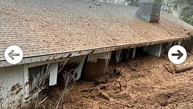
Residents of Lake Charles heard Laura’s winds howling and the sound of breaking glass as the storm passed through the city of 78,000 with winds of 85 miles per hour (137 km per hour) and gusts up to 128 mph (206 kph) in the hour after landfall.

National Guard troops cleared debris from roads in Lake Charles on Thursday afternoon. There were downed power lines in streets around the city, and the winds tipped a few semi-trucks onto their sides.

The windows of the city’s 22-floor Capital One Tower were blown out, street signs were toppled and pieces of wooden fence and debris from collapsed buildings lay scattered in the flooded streets, video footage on Twitter and Snapchat showed.

Lake Charles resident Borden Wilson, a 33-year-old pediatrician, was anxiously anticipating his return home after evacuating to Minden, Louisiana.

“I never even boarded up my windows. I didn’t think to do that. This is the first hurricane I’ve experienced. I just hope my house is fine,” he said in a telephone interview.

In the small town of Starks, about 25 miles northwest of Lake Charles, pine trees strewn across roads and homes were the biggest challenge in cleaning up.

Rev. Karl Smith carefully inspected the damage done to buildings around his First Pentecostal Church. He rode out the storm in the cellar of his house – and had to cut through trees so that he and his wife could get out.

“We just had trees thrown everywhere,” Smith said. “It’s a big mess.”

HIGH WATERS, TORNADO THREATS

Laura made landfall just before 1 a.m. (0600 GMT) as a Category 4 storm packing winds of 150 mph in the small town of Cameron, Louisiana, the National Hurricane Center (NHC) said.

It rapidly weakened to a Category 1 storm on Thursday morning with maximum sustained winds of 75 mph (120 kph), and has since become a tropical storm.

The NHC warned that high water levels would persist along the Gulf Coast for several hours as Laura moved north and then northeast.

Besides threatening life, the storm slammed the heart of the U.S. oil industry, forcing oil rigs and refineries to shut down production.

The Port of Lake Charles remained closed as workers were unable to enter or exit the facility due to downed power lines and trees.

The port avoided significant flooding but power was out as of Thursday morning, manager of security and safety Ed Manint said. The harbor police were assessing the damage, he said.

‘LESS SURGE THAN WE THOUGHT’

Federal Emergency Management Agency (FEMA) Administrator Pete Gaynor told Fox News that the agency would make storm damage assessments on Thursday and had the resources to respond to the storm now, adding he expected to see significant damage from wind and building damage.

“I think we’re generally fortunate – less surge than we thought,” Gaynor said.

The NHC on Wednesday predicted storm surge would be “unsurvivable” and could penetrate up to 40 miles inland. While the worst projections had not materialized, damaging winds and flooding rainfall would continue spreading inland later on Thursday, the NHC said.

Laura could spawn tornadoes on Thursday over Louisiana, Arkansas and western Mississippi, and was expected to drop 4 to 8 inches (10-20 cm) of rain across portions of that region, the NHC said.

(Reporting by Elijah Nouvelage in Lake Charles, La., Ernest Scheyder in Starks, La., Jennifer Hiller and Gary McWilliams in Houston, Liz Hampton in Denver, Timothy Ahmann, Susan Heavey and Daphne Psaledakis in Washington; Gabriella Borter and Peter Szekely in New York and Brad Brooks in Lubbock, Tex.; Writing by Gabriella Borter; Editing by Marguerita Choy and Matthew Lewis)

Hurricane Isaias heads toward Florida with 75-mph winds – Hurricane Center

By Zachary Fagenson

MIAMI (Reuters) – Heavy rains from Hurricane Isaias could hit Florida late Friday night before the powerful storm moves up the East Coast into early next week, the U.S. National Hurricane Center (NHC) warned, prompting the closure of COVID-19 testing sites.

The hurricane, packing maximum sustained winds of 75 miles (120.7 km) per hour, is currently lashing the southeastern part of the Bahamas and the Turks and Caicos Islands, the Miami-based forecaster posted on its Twitter feed on Friday.

“Heavy rains associated with Isaias may begin to affect south and east-Central Florida beginning late Friday night, and the eastern Carolinas by early next week, potentially resulting in isolated flash and urban flooding, especially in low-lying and poorly drained areas” the NHC said on its website.

Miami-Dade County officials closed drive-through and walk-up testing sites for COVID-19. Public beaches, parks, marinas, and golf courses were also set to close on Friday as Isaias strengthened to a Category 1 hurricane and forecasters predicted it would reach Category 2.

Broward County Mayor Dale V.C. Holness had on Thursday also announced testing sites would close, with plans to reopen on Wednesday morning.

As of Friday morning the storm was predicted to most impact Florida’s central, eastern region before moving north.

At full capacity Florida had 162 test sites in all but two of the state’s 67 counties. Some counties will continue testing through their individual health departments.

“We have thousands of tests that will not be conducted until we get these test sites up and running again,” Miami-Dade County Mayor Carlos Gimenez said in a virtual news conference on Friday morning.

(Reporting by Nathan Layne in Wilton, Connecticut; Editing by Nick Zieminski and Jonathan Oatis)

Hanna pummels Texas coast with strong winds, heavy rain

By Adrees Latif

PORT MANSFIELD, Texas (Reuters) – Hanna, the first hurricane of the 2020 Atlantic season, left a trail of destruction along the Texas coast on Sunday, downing power lines, flooding streets and toppling 18-wheeler trucks as torrential rains threatened the area.

Hanna came ashore on Padre Island on Saturday afternoon as a Category 1 hurricane on the five-step Saffir-Simpson scale of intensity and later made a second landfall in Kenedy County, Texas. It swept through a part of the state hard hit by the coronavirus pandemic. By Sunday, it had weakened to a tropical depression.

Powerful winds from Hanna knocked over at least three 18-wheeler trucks and a recreational vehicle, with tow trucks trying to right the toppled vehicles on Sunday, shutting down a 2-mile (3.2-km) stretch of U.S. Route 77 in Sarita, Texas, near the Mexican border.

In Port Mansfield, 150 miles (240 km) south of Padre Island, winds flattened sugarcane fields and leveled trees. Deer roamed the streets, stopping to nibble downed branches in the yards of homes, some that lost their roofs.

Heavy downpours of more than a foot (30 cm) of rain flooded roadways and swelled streams and rivers across south Texas, the National Weather Service said.

There were no immediate reports of injuries.

“You could hear the wind blowing and the rain blowing and you looked outside you could see sheets of water blowing down the street,” said Sharon Pecce, 75, a resident of Port Mansfield, whose roof was ripped off her house on Saturday night.

“It’s scary to go through this at my age, a lot could have happened … we could have been killed,” added Pecce, who was at a friend’s home with her 70-year-old husband when the damage occurred. “We are lucky we weren’t there.”

Roderick Kise, a spokesman for U.S. Customs and Border Protection in the Rio Grande Valley, told the Caller Times newspaper in Corpus Christi that his agency was looking into a report that winds toppled a newly constructed portion of the border wall built between the United States and Mexico.

At one point, more than 283,000 homes and businesses were without electricity. But that figure fell to 98,000 by Sunday night, according to poweroutage.us.

The storm was not expected to affect offshore oil-and-gas production. Energy companies have not evacuated workers or shut down production from their Gulf of Mexico platforms because of Hanna.

Some residents took advantage of the wild weather, with Alejandero Carcano, 16, and Jesse Garewal, 18, both of Galveston, surfing the high swells whipped up by Hanna.

Governor Greg Abbott said in a statement on Sunday that the Federal Emergency Management Agency declared the storm a federal emergency and would help fund evacuation and shelter efforts.

“I continue to urge Texans to heed the guidance from their local leaders and follow best practices to keep themselves and their loved ones safe as severe weather continues to move through our communities,” he said.

The Texas area struck by Hanna has struggled to contain outbreaks of COVID-19 in recent weeks. Cases along the state’s coast have soared into the tens of thousands.

More than 440 people in the Corpus Christi area were hospitalized with the illness, according to the state health department.

STILL A THREAT

Weakening as it headed west over land, Hanna’s center on Sunday was about 35 miles (55 km) from Monterrey, Mexico, as it moved 9 miles per hour (15 kph), the U.S. National Hurricane Center said in a bulletin posted at 4 p.m. (2100 GMT).

The storm’s top sustained winds were around 35 mph (56 kph), the center said.

The storm was forecast to lose more steam as it moved across Texas and northeastern Mexico. On Sunday, weather watch officials canceled a storm surge warning they had issued for the Texas coast.

Hanna still posed a threat, forecasters said, noting it could dump upward of 18 inches (45 cm) of rain in isolated areas of southern Texas through Monday.

“This rain will produce life-threatening flash flooding, rapid rises on small streams, and isolated minor-to-moderate river flooding,” the NHC said.

In the Pacific, Hurricane Douglas was churning near Hawaii on Sunday, with torrential rains and damaging winds.

(Reporting by Adrees Latif; Additional reporting by Raissa Kasolowsky, Barbara Goldberg and Brendan O’Brien; Editing by Daniel Wallis, Lisa Shumaker and Peter Cooney)

Heavy rains bring both relief and new dangers to bushfire-hit Australia

By Sonali Paul and Jonathan Barrett

MELBOURNE/SYDNEY (Reuters) – A four-day downpour across Australia’s east coast has brought relief after months of devastating bushfires and years of drought, but also widespread storm damage and forecasts of more wild weather to come.

The weekend drenching represented the biggest sustained run of rainfall in Sydney and surrounding areas for 30 years, dousing some bushfires and replenishing depleted dams across New South Wales, the country’s most populous state.

Some rural areas received more rain in recent days than they had in the entirety of the past year – a startling and swift turnaround from the bushfires that have killed 33 people and ravaged large parts of the east coast.

“It’s amazing what the smell of the rain can do to people’s spirits,” Ben Shields, the mayor of the inland city of Dubbo, told Reuters on the phone.

Like many other rural towns, Dubbo has been beset by duststorms and subjected to water restrictions on the back of a three-year drought.

James Jackson, a sheep and cattle farmer in the drought-hit Guyra district some 500 kilometers (311 miles) north of Sydney, told Reuters the region was starting to turn green again.

“This one event won’t replenish the whole soil moisture profile. We’ll need a couple of these, but this is certainly a good start for those people who got it,” said Jackson, who is also the president of industry body NSW Farmers.

“I have two-year-old sheep who are seeing green grass for the first time.”

Bushfire warning signs were almost swamped by floods in several areas as the weekend rainfall cut power to tens of thousands of homes, caused travel chaos in Sydney and closed scores of schools for the start of the week.

Almost 400 millimeters (15.8 inches) of rain fell in the Sydney area and surrounding areas. The Warragamba Dam, which supplies about four-fifths of Sydney’s water, jumped from about 40% to above 60% full in just over a week, the state’s water authority said, shoring up water supplies for the city of 5 million.

The NSW Rural Fire Service’s Sydney headquarters has been reconfigured to respond to floods and storm damage because of the rapid shift in the weather threat.

WILDFIRES EXTINGUISHED

Parts of northern and inland NSW, along with southern Queensland, have been in drought since 2016, severely reducing river and dam levels while also creating the tinder-dry conditions that have fueled this season’s deadly bushfires.

The weekend rain extinguished some of the worst bushfires in NSW, including the Gospers Mountain ‘megafire’ in the Blue Mountains and the Currawon blaze on the south coast. Each burned for months, together razing more than 1 million hectares (2.5 million acres) of bushland and destroying hundreds of homes.

In contrast, flood evacuation warnings have now been ordered for parts of the Conjola region, authorities said, where deadly fires razed dozens of homes on New Year’s Eve. Thunderstorms are forecast for NSW and neighboring Victoria state in coming days.

The rain has put some much-needed moisture into parched land months out from the all-important wheat-planting season which is crucial to the fortunes of Australia’s biggest crop.

Phin Ziebell, agribusiness economist at National Australia Bank, said the rain would also encourage farmers in the north-east state of Queensland to rebuild their stock numbers now they had water and feed.

“Some of the driest parts of Queensland have received a drenching, which will help pasture growth,” Ziebell said.

(Reporting by Sonali Paul in Melbourne and Jonathan Barrett in Sydney; additional reporting by Colin Packham; Editing by Peter Cooney and Jane Wardell)