Storms that slammed Central America in 2020 just a preview

By Sarah Marsh and Sofia Menchu

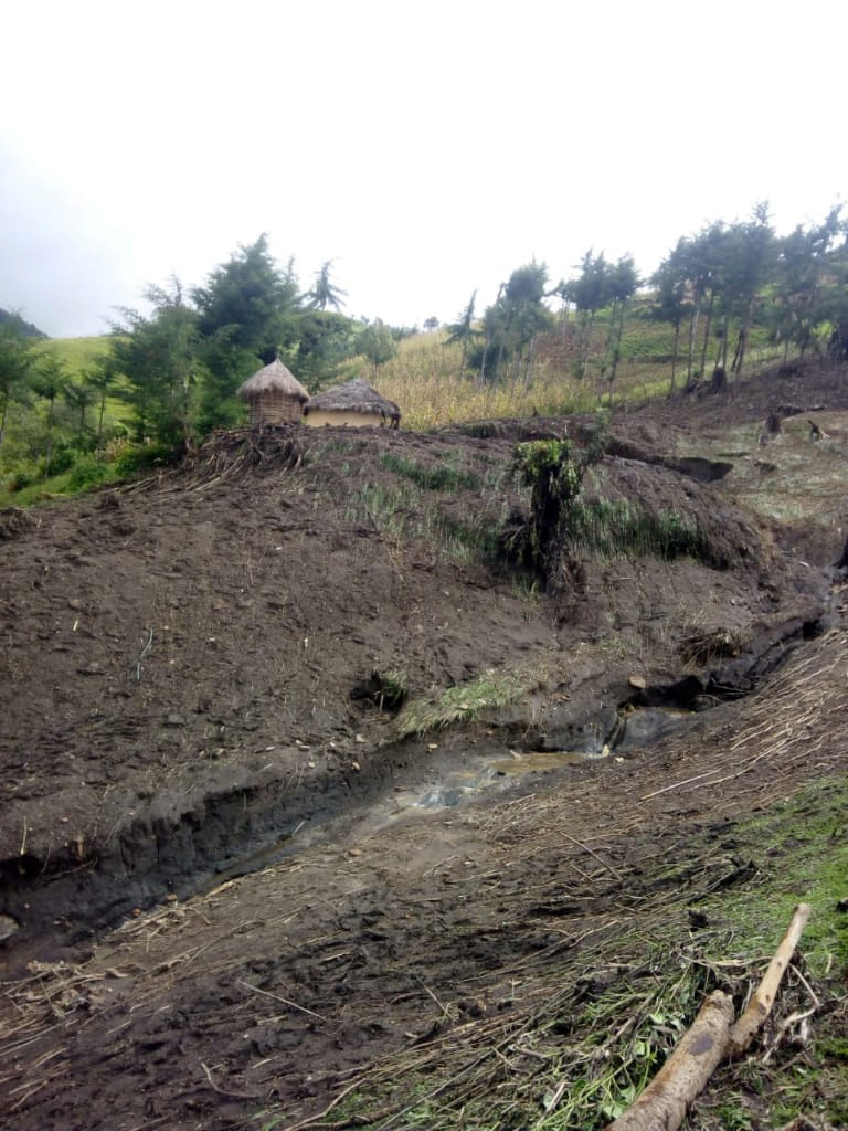
HAVANA/GUATEMALA CITY (Reuters) – Villagers in Guatemala’s Mayan hillside hamlet Sanimtaca had been about to harvest their cardamom crops that take three years to grow when waves of floodwater triggered by two tropical storms last month washed them away.

Now they have no way to support themselves or to build back the 25 homes – a third of the village – also destroyed in the flash floods that have yet to subside, said Raul Quib, a volunteer from a neighboring community.

“No one had ever seen flooding like it around here,” the 35-year-old who has been collecting food and clothing donations told Reuters. “The school is flooded, the cemetery is flooded.”

This week brought an official close to the most active Atlantic hurricane season ever recorded, with 30 named storms including 13 hurricanes.

And thanks to climate change, experts warn, Central America will have to brace for stronger storm impacts in the future – as well as higher economic damages, unless they prepare.

The region, which already has some of the highest poverty rates in Latin America, was particularly hard hit by hurricanes this year.

Two of the year’s strongest storms, Eta and Iota, ravaged swathes of Panama, Costa Rica, Honduras, Nicaragua, El Salvador, Guatemala and Belize in unusually quick succession in November.

Altogether, more than 200 people were killed and more than half a million displaced. Hundreds of thousands are now unsure where their next meals will come from.

In Sanimtaca, villagers were able to flee to higher ground in time to escape the flooding. But elsewhere in the mountainous central Guatemalan region of Alta Verapaz, storm-triggered landslides buried dozens of houses with people inside.

Hurricane Eta alone caused up to $5.5 billion in damage in Central America, the Inter-American Development Bank said, while the impact of Iota has not yet been determined.

So far, only Nicaragua has provided official estimates of damage of both storms, putting it at more than $740 million, around 6.2% of gross domestic product.

“If we don’t manage to contain global warming to 2 degrees Celsius, we can expect an intensification of such natural disasters in the region with increasing costs,” said Luis Miguel Galindo, climate change expert and economics professor at Mexico’s UNAM university.

Currently, the world is on track to surpass 2°C of warming above pre-industrial temperatures.

If temperatures rise 2.5 °C by mid-century, the main costs of climate change could tally 1.5% to 5% of the annual GDP of Latin America and the Caribbean, according to a 2017 United Nations report that Galindo co-authored. It put the cost of adapting below 0.5% of GDP.

SLOWER STORMS, LONGER SEASON

Climate change overall is changing how hurricanes behave, scientists say, by warming up the ocean water through which they draw their power. Winds are blowing stronger. Storms are dropping heavier rains.

“We have more energy embedded in the oceans, and 90% from climate change,” said Belizean meteorologist Carlos Fuller, the lead climate change negotiator for the Alliance of Small Island States.

And hurricanes are sometimes moving more slowly, stalling for longer on land or traveling farther before breaking up, recent research has shown.

That can mean even more rainfall, wind and destruction for communities in a storm’s path. In 2017, Hurricane Harvey turned Houston’s highways into tidal rivers after stalling for four days near or over the Texas coast. Scientists say Eta and Sally behaved this way, too, hence the unusual flooding in Sanimtaca.

“The evidence is building that there is a human fingerprint on this behavior,” said Jim Kossin, climate scientist with the National Oceanic and Atmospheric Administration (NOAA). In a study published in June 2018 in the journal Nature, Kossin found that hurricane speeds had decreased worldwide by about 10% between 1949 and 2016.

This year’s storm count included six major hurricanes, twice the long-term average, said meteorologist Philip Klotzbach, who researches hurricanes at Colorado State University.

The year also saw nine storms that rapidly intensified, he said. Iota for example spun from a 70 mile-per-hour (113 km-per-hour) tropical storm to a 160-mph (257-kph) Category 5 hurricane in 36 hours. The only other years that saw so many such storms were 1995 and 2010.

That can be “a problem from the warning, preparation perspective,” Klotzbach said. “It is hard to prepare if it’s a tropical storm, and then a day later a Category 4 hurricane.”

More storms could also hit outside of the traditional hurricane season going forwards as ocean waters get warmer sooner, said Susan Lozier, an oceanographer and dean at the Georgia Institute of Technology’s College of Sciences. This year, a record-tying two tropical storms were swirling over the Atlantic in May, before the season’s June 1 start.

But it is still unclear if climate change is influencing the number of storms per year and played a role in the record 30 named storms in the Atlantic Ocean this season given natural variability. The number of hurricanes and major hurricanes for the Northern Hemisphere was near average due to a quieter Pacific.

BOLSTERING RESILIENCE

Communities devastated by a hurricane need to find ways to reduce the risk of damages should another hurricane hit, said World Bank regional sustainable development expert Anna Wellenstein.

Natural hazards “become disasters when we build in the wrong place or in the wrong way,” she said. “Countries need more than a few years to really increase their resilience. This is an effort of decades.”

Moving populations away from coastlines vulnerable to floods and storm surges or hillsides that see landslides could help prevent deaths, some experts suggest. Storm predictions and warning systems could be improved. And vulnerable crops can be swapped out for hardier species.

“Rice can survive (rain) water because it grows in water,” said Fuller, the meteorologist in Belize. “So maybe we need to shift to that sort of grain instead of maize for example which will fall.”

A dollar invested in more resilient infrastructure brings four dollars in economic benefits, said Wellenstein.

But many Central American and Caribbean countries, already confronted with poverty and debt, have struggled to prioritize this among so many other pressing needs.

“They don’t have the resources,” said Galindo. “And the pandemic is further reducing revenue and increasing expenses.”

Guatemala’s President Alejandro Giammattei said last month Central America had been the worst affected region in the world by climate change and it would need help from them to stave off mass migration.

Quib, who volunteered to help Sanimtaca, said he expected most of the youth of the village to emigrate to Canada where they could lead a better life.

“If they were already doing it before this happened, they will do so even more now,” he said.

(Reporting by Sarah Marsh in Havana and Sofia Menchu in Guatemala City; Additional Reporting by Laura Gottesdiener in Monterrey, Mexico; Editing by Katy Daigle and Lisa Shumaker)

Death toll from Iota slowly rises in Central America amid ongoing rescue efforts

By Gustavo Palencia and Ismael Lopez

TEGUCIGALPA/MEXICO CITY (Reuters) – The death toll from storm Iota is slowly rising in Central America as authorities on Thursday said they’d recovered more bodies buried in landslides triggered by catastrophic flooding that swept through the already waterlogged region earlier this week.

Nearly 40 people were killed across Central America and Colombia, and the toll is expected to rise as rescue workers reach isolated communities. Most of the deaths have occurred in Nicaragua and Honduras.

The strongest storm on record to hit Nicaragua, Iota struck the coast late on Monday as a Category 4 hurricane. It inundated low-lying areas still reeling from the impact two weeks ago of Eta, another major hurricane that killed dozens of people in the region.

On Thursday morning, Honduran authorities raised the death toll to 14 after confirming that eight members of two families, including four children, were killed when a landslide buried their homes in a village in a mountainous region populated by indigenous Lencas near the border with El Salvador.

In Nicaragua, where a total of 18 people have been confirmed dead, rescue efforts continue after a landslide in the north of the country killed eight people, with more missing.

While Iota largely dissipated over El Salvador on Wednesday, authorities struggled to cope with the fallout from days of heavy rain.

Numerous villages from northern Colombia to southern Mexico saw record rainfall swell rivers and trigger mudslides. Cities like the Honduran industrial hub of San Pedro Sula were also hit hard, with the city’s airport completely flooded and jetways looking more like docks, video posted on social media showed.

Some 160,000 Nicaraguans and 70,000 Hondurans have been forced to flee to shelters.

Experts say the destruction caused by the unprecedented 2020 hurricane season in Central America could spur more migration out of the region, which is coping with insecurity and an economic crisis triggered by coronavirus pandemic-related lockdowns imposed earlier this year.

(Reporting by Gustavo Palencia in Tegucigalpa and Ismael Lopez in Mexico City; Additional reporting by Wilmer Lopez in Puerto Cabezas, Sofia Menchu in Guatemala City and Nelson Renteria in San Salvador; Writing by Laura Gottesdiener and David Alire Garcia; Editing by Jonathan Oatis)

Indonesia seeds clouds to keep them away from flooded capital

By Bernadette Christina and Jessica Damiana

JAKARTA (Reuters) – Indonesia’s air force seeded clouds with salt on Friday to try to stop rainfall reaching the slowing sinking capital after deadly flash floods and landslides triggered by some of the heaviest rain ever recorded.

The death toll in Jakarta and surrounding areas rose to 43 as of Friday, the disaster mitigation agency said, while tens of thousands of people have been displaced.

Indonesia’s technology agency BPPT and the air force carried out three rounds of cloud seeding on Friday, with more expected when needed, a BPPT official said.

The seeding, shooting salt flares in an attempt to trigger rainfall, is aimed at breaking up clouds before they reach Jakarta.

“We will do cloud seeding every day as needed,” BPPT chief Hammam Riza told reporters.

Cloud seeding is often used in Indonesia to put out forest fires during the dry season.

The floods followed torrential rains on Dec. 31 and into the early hours of New Year’s Day that inundated swathes of Jakarta and nearby towns, home to about 30 million people.

The deluge at the start of 2020 was “one of the most extreme rainfall” events since records began in 1866, the Meteorological, Climatological and Geophysics Agency (BMKG) said on Friday.

The agency said climate change had increased the risk of extreme weather and warned that heavy rainfall could last until mid-February, with Jan 11-15 an expected peak.

Television footage showed flood waters inundating parts of Southeast Asia’s largest city and mud-covered cars, some piled on top of each other.

President Joko Widodo blamed delays in flood control infrastructure projects for the disaster, including the construction of a canal that has been delayed since 2017 due to land acquisition problems.

Widodo last year announced he would move Indonesia’s capital to East Kalimantan province on Borneo island to reduce the burden on overpopulated Jakarta.

More than 50 people died in one of the capital’s deadliest floods in 2007 and five years ago much of the centre of the city was inundated after canals overflowed.

Jakarta is sinking by several cm a year in northern parts, an official said in October, due to extraction of groundwater over the years causing layers of rock and sediment to slowly pancake on top of each other.

(Additional reporting by Jakarta bureau; Writing by Gayatri Suroyo; editing by Nick Macfie)

Flood death toll rises to 26 in Jakarta, tens of thousands evacuated

By Agustinus Beo Da Costa and Stanley Widianto

JAKARTA (Reuters) – Tens of thousands of people were evacuated in Indonesia’s capital Jakarta on Thursday after flash floods and landslides killed up to 26 people amid some of the heaviest rain in more than 20 years, with more deluges forecast, authorities said.

The flooding, among the deadliest in years, caused chaos in parts of Southeast Asia’s biggest city with train lines blocked and power outages in some areas. Swathes of Jakarta and nearby towns were inundated after heavy rain fell on Dec. 31 and into the early hours of New Year’s Day.

Social affairs ministry data showed 26 people were killed in the flooding, up from the earlier toll of 21.

As of Thursday morning, over 62,000 people were evacuated in Jakarta alone, disaster mitigation agency spokesman Agus Wibowo said, although later in the day he told news channel Metro TV the number of evacuees were down to around 35,000 people.

Rainfall at an airport in East Jakarta measured at 377 millimeters (15 inches) early on Jan. 1, the highest daily reading during major floods since at least 1996, according to the Meteorology, Clilmatology and Geophysics Agency (BMKG).

Umar Dani, 52, and his family were evacuated overnight from his home in East Jakarta on a rubber boat after water levels rose up to his neck.

“It has not flooded for so long here. We didn’t have the chance to bring anything,” he said.

“I have to live on the streets now.”

President Joko Widodo told reporters evacuation and safety measures should be prioritized and called for more coordination between city administrations and the central government.

On his Twitter page, Widodo blamed delays in flood control infrastructure projects for the flooding. He said some projects have been delayed since 2017 due to land acquisition problems.

“EXTREME WEATHER” EXPECTED

Jakarta governor Anies Baswedan said authorities deployed hundreds of pumps to suck water from residential areas across the capital, which had allowed some people to return home.

“They want to return home immediately and start cleaning up their houses as soon as they are able to enter their houses as water recedes,” Baswedan told reporters during a visit to a densely populated area in East Jakarta affected by the flood.

Residents waddled through murky water to see the governor while workers pumped water out of the area into a nearby river.

The mitigation agency said on its Twitter page that water levels have come down in a few affected areas, showing pictures of streets covered by mud and littered with debris.

Authorities however warned people to remain vigilant as “extreme weather” is expected to continue until Jan. 7.

Dwikorita Karnawati, head of the Meteorological, Climatological and Geophysics Agency (BMKG), told reporters separately that heavy rainfall may continue until mid February.

Television footage on Thursday showed rescuers in the nearby city of Tangerang evacuating residents, guiding them across a strong current by holding on to a rope.

Jakarta and its surroundings are home to more than 30 million people. More than 50 people died in one of the capital’s deadliest floods in 2007 and five years ago much of the centre of the city was inundated after canals overflowed.

The government announced last year that it is relocating the capital to East Kalimantan province on Borneo, though the planning ministry pledged that the government will invest $40 billion in modernizing Jakarta.

(Additional reporting by Jakarta bureau; Editing by Matthew Tostevin, Kim Coghill, William Maclean)

Death toll from Kenya landslides rises to 56 as heavy rains lash country’s north west

People walk in the mud after heavy rains caused landslides in the village of Parua, West Pokot County, Kenya November 23, 2019. REUTERS/Moses Lokeris


MOMBASA (Reuters) – The death toll from landslides in northwestern Kenya triggered on Saturday by unusually heavy rains has risen to at least 56 people, a local official said.

The downpour began on Friday in West Pokot County, which borders Uganda, and worsened overnight, causing flooding and mudslides that swept away four bridges and left villages inaccessible by road.

Samuel Poghisio, a senator from the county, told Reuters by phone on Sunday that 56 people were confirmed dead and an unknown number were missing. By Saturday afternoon, local officials had reported 36 dead.

“Rescue operations are frustrated by more rain and fog,” Poghisio wrote in a text message, adding that police helicopters were struggling to reach the flooded areas.

Kenya’s president on Saturday deployed rescue personnel from agencies including the army and the police to try and prevent the “further loss of lives”.

Houses are seen covered by mud after heavy rains caused landslides in the village of Parua, West Pokot County, Kenya November 23, 2019. REUTERS/Moses Lokeris

Researchers have warned that warming oceans are causing unpredictable weather patterns in East Africa.

Heavy rains and floods have killed more than 50 people and forced hundreds of thousands of people from their homes in the region since October, aid groups said earlier this month.

Kenya is experiencing a heavier than usual rainy season, the Kenya Meteorological Department said in early November.

(Reporting by Joseph Akwiri; Writing by Maggie Fick; Editing by Kirsten Donovan)

Disaster hacks: South American cities harness tech and nature to tackle flooding

By Anastasia Moloney

BOGOTA (Thomson Reuters Foundation) – Hit with ever-more-frequent torrential rain that triggers worsening flooding and mudslides most years, Rio de Janeiro is looking to an unusual gathering for answers: a hackathon.

Starting Saturday, teams of university students, tech start-up leaders, software developers and computer engineers will try to come up with innovative ways to help the seaside Brazilian city limit its losses as climate change brings wilder weather.

Tech experts at the city hall-led event hope to, for instance, come up with new ways to leverage data from GPS systems already used in the city’s buses to allow emergency services to better understand and monitor floods in real time.

“We know we have problems of floods and heavy rains, and we see an opportunity to use GPS to know where the flooding and landslide incidents are,” said Simone Silva, a mobility advisor at city hall and one of the organizers.

Right now, “at the very local level, we don’t know exactly what happens,” she told the Thomson Reuters Foundation.

RISING URBANIZATION

Around Latin America, tens of millions of people are at risk from worsening flooding linked to climate change, many of them living in urban slums often built along rivers or on mountain slopes prone to landslides.

About 80% of Latin America’s people live in the region’s urban areas, according to the United Nations.

But across the region, cities are working to cut the risks, harnessing technology, better data and insights from affected communities to come up with new ways to keep people safe.

Flooding is clearly seen as one of the most severe threats. Of 530 cities worldwide that reported their climate hazards in 2018 to CDP, a London-based international environmental non-profit, 71% said floods were their top worry.

Extreme heat came next, at 61%, followed by drought at 36%, according to the study, published last month.

But over half of cities have not carried out risk assessments to map which areas, residents and businesses are under threat from extreme weather, the study found.

“We have seen that cities that take vulnerability assessments, they take six times as many actions to adapt as cities that haven’t done them,” said Kyra Appleby, who heads the CDP’s cities, states and regions team.

Geographic information system (GIS) technology that allows data about hazards and climate risks to be overlayed with existing maps of cities has made it easier for authorities to do risk assessments, she added.

That and other technologies are among the measures being used in a range of cities around Latin America to deal with worsening economic and human losses from floods.

In recent decades, Rio de Janeiro, for instance, has put in place early warning systems to help evacuate people ahead of threats, mapped of floodplain areas, built shelters and conducted emergency drills in slum areas, Appleby said.

The city also has installed cameras to monitor street flooding and set up social media alert systems.

Other cities are introducing digital sensors to try to cut risks. Argentina’s capital, Buenos Aires, is developing a network of sensors to monitor rainfall and feed back data in real time to the city’s central control centre.

Ensuring climate change adaptation measures are included in all urban planning is crucial, Appleby said, noting that the city of Belo Horizonte, in Brazil’s Minas Gerais state, is one of those leading the way.

“It’s in the process of creating a new masterplan for the city and they are integrating all their adaption measures into their masterplan. That is really ahead of the curve,” she said.

To be effective, climate adaption plans must include the input of local communities, according to Anjali Mahendra, head of research at the World Resources Institute Ross Center for Sustainable Cities.

“Latin American cities are particularly good with involving communities,” she said.

That’s largely because early urbanization in the region means cities have had longer experience working with informal settlements and other disadvantaged communities, she said.

African and South Asian cities, facing rapid urbanization are “starting to learn from some Latin American cities,” Mahendra said.

Colombia’s second city of Medellin and Ecuador’s capital Quito – which has a climate change panel that includes youth, women and indigenous groups – in particular have worked hard to include local communities in decisions about urban planning and climate risks, said Mahendra.

USING NATURE

To tackle growing flood threats, more investment also is needed in “nature-based solutions” – such as expanding green areas to absorb floodwaters, said Pedro Ribeiro, head of the Urban Flooding Network at C40, a group of cities pushing climate action.

Creating green buffer areas to stem urban sprawl and protecting and restoring degraded ecosystems around cities, including forests, watersheds, grasslands and wetlands, can help slow the movement of water and avoid flooding, he said.

“It’s easier to recover ecosystems that were in the city before building .. and the results are better” than trying to establish wholly new anti-flooding systems, Ribeiro said.

(Reporting by Anastasia Moloney @anastasiabogota, Editing by XXXX. Please credit the Thomson Reuters Foundation, the charitable arm of Thomson Reuters, that covers humanitarian news, women’s and LGBT+ rights, human trafficking, property rights, and climate change. Visit http://news.trust.org)

India floods kill more than 270, displace one million

FILE PHOTO: Rescuers remove debris as they search for victims of a landslide caused by torrential monsoon rains in Meppadi in Wayanad district in the southern Indian state of Kerala, India, August 10, 2019. REUTERS/Stringer

By Gopakumar Warrier and Rajendra Jadhav

BENGALURU/MUMBAI (Reuters) – Floods and landslides have killed more than 270 people in India this month, displaced one million and inundated thousands of homes across six states, authorities said on Wednesday after two weeks of heavy monsoon rains.

The rains from June to September are a lifeline for rural India, delivering some 70% of the country’s rainfall, but they also cause death and destruction each year.

The southern states of Kerala and Karnataka, and Maharashtra and Gujarat in the west, were among the hardest hit by floods that washed away thousands of hectares of summer-sown crops and damaged roads and rail lines.

At least 95 people were killed and more than 50 are missing in Kerala, where heavy rainfall triggered dozens of landslides last week and trapped more than 100 people.

About 190,000 people are still living in relief camps in the state, said Chief Minister Pinarayi Vijayan, but he added some people are returning home as floodwaters recede.

In neighboring Karnataka, home to the technology hub Bengaluru, 54 people died and 15 are missing after rivers burst their banks when authorities released water from dams.

Nearly 700,000 people have been evacuated in the state.

Heavy rainfall is expected in parts of Karnataka, Maharashtra and Gujarat, as well as the central state of Madhya Pradesh, in the next two days, weather officials said.

In Maharashtra, which includes the financial capital Mumbai, 48 people died but floodwaters are receding, said a state official.

“We are now trying to restore electricity and drinking water supplies,” he said.

In Madhya Pradesh, the biggest producer of soybeans, heavy rains killed 32 people and damaged crops, authorities said.

In Gujarat, 31 people died in rain-related incidents, while landslides killed nearly a dozen people in the northern hilly state of Uttarakhand.

(Reporting by Gopakumar Warrier and Rajendra Jadhav; Editing by Euan Rocha and Darren Schuettler)

Japan, hit by torrential rains, orders over one million to evacuate

A pedestrian walks through heavy rain in Kirishima, Kagoshima Prefecture, southwestern Japan, July 3, 2019, in this photo taken by Kyodo. Mandatory credit Kyodo/via REUTERS ATTENTION EDITORS - THIS IMAGE WAS PROVIDED BY A THIRD PARTY. MANDATORY CREDIT. JAPAN OUT. NO COMMERCIAL OR EDITORIAL SALES IN JAPAN. THIS IMAGE WAS PROCESSED BY REUTERS TO ENHANCE QUALITY, AN UNPROCESSED VERSION HAS BEEN PROVIDED SEPARATELY.

TOKYO (Reuters) – Japan ordered more than one million people on the southernmost island of Kyushu to take shelter in evacuation centers and other safe areas on Wednesday as heavy rains triggered small landslides and threatened to cause widespread flooding.

Some parts of southern Kyushu have received over 1,000 mm (39.4 inches) of rain since Friday, about as much as usually falls in the whole month of July, broadcaster NHK said.

The Futami River is swollen due to heavy rain in Yatsushiro, Kumamoto Prefecture, southwestern Japan, July 3, 2019, in this photo taken by Kyodo. Mandatory credit Kyodo/via REUTERS

Forecasters expect as much as 300 mm more rainfall in some areas by Thursday evening.

Evacuation orders were issued for 1.1 million residents of Kagoshima and Miyazaki prefectures at the southern tip of Kyushu, NHK said. Some 930,000 more were advised to leave.

Only some 3,500 people had evacuated as of 4:00 p.m. (0700 GMT), according to the Fire and Disaster Management Agency.

“I live alone next to a river, and it’s scary to think of water rising,” one woman in an evacuation center told NHK. Another person said the volume of rainfall was “terrible”.

Television footage showed rivers filled with fast-moving brown water, but none had overflowed their banks as of Wednesday evening, although one low dike had broken and efforts were being made to repair it with sandbags.

Several small landslides were reported, including one that swept away two cars and damaged a pre-fabricated shed. A mother and child in another car swept away by a landslide sustained minor injuries.

“The rain was just flowing all over the rice fields,” one woman told NHK.

A Twitter user posted a photo of a road covered with brown water. “Whoa, the road I take to work is a mess,” the user wrote.

In Tokyo, Prime Minister Shinzo Abe said residents should “take steps to protect their lives, including early evacuation,” and he ordered the military to prepare for rescue operations.

Abe was criticized for the government’s slow response in July a year ago, when heavy rains triggered landslides and floods, killing more than 200 people in Japan’s worst weather disaster in 36 years.

(Reporting by Chang-Ran Kim, Linda Sieg, Yuri Harada and Elaine Lies; Editing by Darren Schuettler and Tom Hogue)

Death toll in floods in Indonesia’s Papua rises to nearly 80

Cars are submerged in mud following a flash flood in Sentani, Papua, Indonesia, March 17, 2019 in this photo taken by Antara Foto. Antara Foto/Gusti Tanati/ via REUTERS

JAKARTA (Reuters) – Authorities in Indonesia raised the death toll from floods and landslides in the easternmost province of Papua to nearly 80 on Monday as President Joko Widodo called for the urgent evacuation of victims from devastated communities.

The deadly floods and landslide struck at the weekend after torrential rain fell across the Cyclops mountain range, much of which has been stripped of tree cover by villagers chopping fire wood and farmers cultivating plantations.

The death toll shot up to nearly 80 from 58 on Sunday as rescuers found more victims as they struggled to clear mud, rocks and shattered trees from the area near the provincial capital of Jayapura, including a 70 km stretch of road.

With 43 people missing, Widodo urged rescuers to step up their efforts.

“What is most important is handling the evacuation,” he said in a statement posted on Instagram.

More than 4,000 people have been displaced and are sheltering in tents, schools, and public buildings.

Disaster authorities have warned provincial officials of the danger of flash floods due to deforestation, said Sutopo Purwo Nugroho, spokesman of the national disaster mitigation agency.

The central government sent supplies of seedlings last year, hoping to help restore some forest cover, he said.

(Reporting by Jessica Damiana; Writing by Kanupriya Kapoor)

Philippines evacuates coastal areas ahead of typhoon Yutu

A general view of the damage after Super Typhoon Yutu hit Saipan, Northern Mariana Islands, U.S., October 25, 2018 in this picture taken through a cracked vehicle window, obtained from social media. Brad Ruszala via REUTERS

MANILA (Reuters) – The Philippines raised storm warning levels on Monday and began evacuating some coastal communities in the path of a typhoon that threatened storm surges, landslides and floods triggered by heavy winds and rain.

Typhoon Yutu, which caused havoc last week with a direct hit on the U.S. Northern Mariana islands, was set to make landfall on Tuesday morning and move across the main island of Luzon before leaving the Philippines 24 hours later, the state weather agency PAGASA said.

By mid-morning on Monday, Yutu was about 400 km (249 miles)east of the mainland and had weakened to sustained wind speeds of 150 km per hour (93 mph), with gusts of 185 kph, from 170 kph recorded a few hours earlier.

That was less intense than four days ago, when as a super typhoon with wind speeds of over 270 kph barreled through the Marianas, a U.S. Western Pacific archipelago of 52,000 people, tearing off roofs, overturning vehicles and cutting off power and water.

Authorities in Isabela and Cagayan provinces started moving residents in coastal towns to evacuation centers while the mountainous Cordillera region was put on red alert for landslides.

Three provinces in north Luzon were elevated to warning signal 3 on the severity scale of 5, and 28 more put on the earliest warnings of 1 and 2, with strong winds and rains expected later on Monday.

Known locally as Rosita, the typhoon will be the 18th to hit the Philippines this year and comes six weeks after super typhoon Mangkhut tore across Luzon, triggering landslides that killed dozens of people and damaged about $180 million of crops.

School classes were suspended in at least five provinces and fishermen in Luzon and the eastern seaboard advised not to go to sea, with warnings of storm surges of up to three metres in six provinces.

All boat services in the port city of Batangas, about 83 km (52 miles) south of Manila, were suspended on Monday.

About half of the Philippines’ 105 million population live in the Luzon region. The country is hit by an average 20 typhoons each year.

(Reporting by Martin Petty and Karen Lema; editing by Darren Schuettler)