Tornadoes rip through Kansas after one killed, scores hurt by Ohio twisters

A man named Luther cleans up his driveway of debris after a tornado touched down overnight in city of Trotwood near Dayton, Ohio, U.S. May 28, 2019. REUTERS/Aaron Josefczyk

BROOKVILLE, Ohio (Reuters) – Several tornadoes reportedly touched down on Tuesday evening in Kansas to damage homes, uproot trees and rip down power lines, the National Weather Service (NWS) said.

About 20 tornadoes, including a large rain-wrapped twister near Kansas City, were reported to the NWS by storm chasers and spotters as news broadcast images of roofs torn off homes and roads scattered with debris and tree limbs.

“The house took a pretty good beating … but the main thing is that we are all safe,” homeowner Brian Perry told 41 Action News in Kansas City. “It was pretty wild, never been through anything like it in my life.”

The extent of the damage was unclear and there were no reports of fatalities or injuries.

The Kansas City International Airport said on Twitter that travelers found shelter in parking garage tunnels as the storms passed by the airfield. The airport later said it was closed as crews cleared debris.

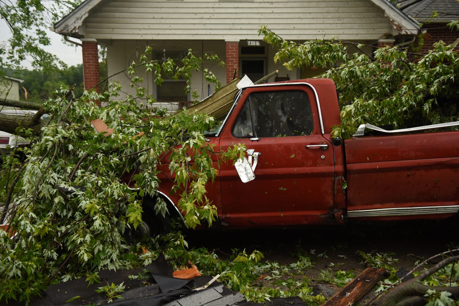
The latest wave of tornadoes came a day after a spate of twisters pulverized buildings in western Ohio, killing one person, injuring scores and triggering a recovery effort in neighborhoods strewn with wreckage.

An 81-year-old man was killed in Celina, a small city 65 miles (105 km) north of Dayton, after a tornado sent a vehicle crashing into his home, Mayor Jeffrey Hazel told a news conference.

More than 300 tornadoes have ravaged the U.S. Midwest in the last two weeks, during an unusual onslaught of extreme weather.

The tornado in Celina, which touched down late on Monday, was at least an EF3 on the Enhanced Fujita Scale, packing wind speeds of 136 mph to 165 mph (219 kph to 266 kph), said Patrick Marsh, a meteorologist at the federal Storm Prediction Center.

The storm injured seven people in Celina, three of them seriously, Hazel said, and about 40 homes there were seriously damaged or destroyed.

Two tornadoes categorized as EF3 or stronger also struck late on Monday near Dayton, including one just south of Wright-Patterson Air Force Base, Marsh said. An EF3 is just two scales lower than the most intense tornado possible, an EF5.

Damaged property is seen after a tornado in Lawrence, Kansas, U.S. in this still from a video taken May 28, 2019 obtained from social media. LOUIS CORTEZ /via REUTERS

Damaged property is seen after a tornado in Lawrence, Kansas, U.S. in this still from a video taken May 28, 2019 obtained from social media. LOUIS CORTEZ /via REUTERS

‘LIKE A FREIGHT TRAIN’

Sue Taulbee, 71, was watching television in her bed in the Dayton suburb of Brookville when she heard an approaching twister.

“They say it’s like a freight train: That’s what I heard,” she recalled on Tuesday afternoon. She hid at the foot of the bed. Flying debris smashed her window and she was soon trapped as her home collapsed around her.

“It was only a couple of minutes, but it seemed like an hour,” she said as she sat in her yard, surrounded by her scattered possessions.

“I just started screaming and my neighbors heard me and said, ‘Sue! Sue! I hear you! We’re coming! We’re coming!'”

They pulled her out through a hole and brought her to a hospital to treat a cut on her head, she said.

After the twisters, Ohio Department of Transportation crews used snow plows to clear highways of debris.

The risk of more tornadoes continued into the night on Tuesday in some Midwest states and the mid-Atlantic states of Pennsylvania, New Jersey and southern New York, Marsh said.

‘THROWN AROUND’

Nearly 80 people in and around Dayton went to hospitals with injuries, said Elizabeth Long, a spokeswoman for the Kettering Health Network.

“We’ve had injuries ranging from lacerations to bumps and bruises from folks being thrown around in their houses due to the storms,” Long said.

The flurry of hundreds of tornadoes that has recently struck the Midwest was caused by the interaction of moisture from the Gulf of Mexico, a strong jet stream and a weather front that has been locked in place, said Alex Lamers, a meteorologist with the federal Weather Prediction Center.

Joseph Taulbee, 21, Allyson Smith, 25, and Danielle,Taulbee, 24, work to collect memorabilia from their grandmother’s damaged house after a tornado touched down overnight in Brookville, near Dayton, Ohio, U.S. May 28, 2019. REUTERS/Kyle Grillot

Nearly 55,000 homes and businesses in Ohio were without power on Tuesday, according to the PowerOutage.US tracking service, and officials advised people to boil water after water plants and pumps halted.

The latest storm follows tornadoes and floods that killed at least three people in Missouri and six people in Oklahoma during the previous week, including two in El Reno on Saturday.

Unexpected pipeline outages and refinery shutdowns over the past week – in part caused by bad weather in the U.S. Midwest – have roiled cash markets for both crude oil and refined products, traders said.

Rainfall could trigger flash flooding on Tuesday evening in parts of Nebraska, Kansas, Missouri and Iowa, said Brian Hurley, a senior meteorologist at the federal Weather Prediction Center.

(This story corrects dateline and name of Dayton suburb in paragraph 12 to Brookville, not Brookline)

(Reporting by Kyle Grillot in Brookville, Ohio; Additional reporting by Rich McKay in Atlanta, Jonathan Allen and Peter Szekely in New York, Alex Dobuzinskis in Los Angeles and Brendan O’Brien in Milwaukee; Editing by Grant McCool and Clarence Fernandez)

Storms and sweltering heat seen hitting U.S. South on Memorial Day

FILE PHOTO: A path of destruction through the Skyview Mobile Park Estates is seen in an aerial photo after a tornado touched down overnight in El Reno, Oklahoma, U.S. May 26, 2019. REUTERS/Richard Rowe

By Rich McKay

(Reuters) – Sweltering heat, storms and possible twisters were expected to hit the U.S. southern Plains and southeastern states on Memorial Day after a spate of deadly tornadoes and flooding in the region.

Temperatures around 100 degrees Fahrenheit (38 Celsius) were forecast in cities from Jacksonville, Florida, up the southeast into Macon and Savannah Georgia, and on to Charleston, South Carolina, the National Weather Service said.

“This is super hot for this time of year,” said John Deese, a NWS forecaster in Peachtree, Ga., near Atlanta.

“This is a heat wave across the south, and it’s going to be here for a while,” said Deese, predicting high temperatures through the week staying in the mid to high 90s in the region.

The risk of strong tornadoes are moderate but remain possible through the week for the southeastern Plains states, already hit by lethal twisters last week, forecasters said.

The latest severe tornado killed two people in El Reno, Oklahoma late Saturday, injured at least 29 people, and left hundreds homeless, officials said.

Four more people were killed in the same storm in Oklahoma, CNN reported Sunday.

Rescue workers on Sunday searched for survivors in the rubble left by the tornado that devastated parts of the small community near Oklahoma City, officials said.

At least seven other people were killed by storms last week.

U.S. southern Plains including Nebraska, Oklahoma, Kansas and parts of Ohio will remain under flood watches and warnings through the week, as rains, wind, hail and possible twisters are in the forecast, said David Roth of the NWS Weather Prediction Center in College Park Maryland.

As for the southeast from Florida to Virginia – “It’ll stay hot,” he said. “This weather pattern is just parked, persistent.”

(Reporting by Rich McKay in Atlanta; Editing by Andrew Heavens)

Death toll from storms lashing central U.S. rises to seven

A member of the Jefferson City Fire Department checks houses for people on Woodland Avenue following a tornado touchdown overnight in Jefferson City, Missouri, U.S. May 23, 2019. REUTERS/Antranik Tavitian

By Antranik Tavitian

JEFFERSON CITY, Mo. (Reuters) – The latest in a line of destructive storms pounding the central United States killed at least three people as tornadoes raked across Missouri while heavy rain flooded rivers in Oklahoma, authorities said on Thursday.

The three deaths and several injuries were recorded in and around Golden City, Missouri, some 30 miles (48 km) northeast of Joplin where a tornado touched down on Wednesday evening, the Missouri Department of Public Safety said on Twitter.

A damaged car is parked on Woodlawn Avenue following a tornado touchdown overnight in Jefferson City, Missouri, U.S. May 23, 2019. REUTERS/Antranik Tavitian

A damaged car is parked on Woodlawn Avenue following a tornado touchdown overnight in Jefferson City, Missouri, U.S. May 23, 2019. REUTERS/Antranik Tavitian

The casualties brought the week’s weather-related death toll to at least seven, as forecasters said the rain and threat of damaging winds were not expected to let up.

“It looks to stay quite wet over the next week across the central portion of the country,” said meteorologist Mark Chenard of the National Weather Service (NWS) Weather Prediction Center in College Park, Maryland.

A system of showers stretched from the Texas Panhandle and western Oklahoma north to Nebraska on Thursday, threatening to bring more flooding, Chenard said. A diminished threat of tornadoes will persist from the Texas Panhandle through Kansas, he said.

In Jefferson City, the state capital of Missouri, officials said a “massive” twister caused widespread damage but no fatalities.

“Many, many buildings have significant damage, and there’s a lot of them that just have small damage as well, so it’s just very widespread,” Jefferson City Mayor Carrie Tergin told CNN.

Missouri Governor Mike Parson said at least 20 people were treated at hospitals but that most had been released.

A firefighter and FEMA employee survey damage on Woodlawn Avenue following a tornado touchdown overnight in Jefferson City, Missouri, U.S. May 23, 2019. REUTERS/Antranik Tavitian

A firefighter and FEMA employee survey damage on Woodlawn Avenue following a tornado touchdown overnight in Jefferson City, Missouri, U.S. May 23, 2019. REUTERS/Antranik Tavitian

“The damage tornadoes & severe storms cause is devastating, but I am encouraged & inspired by storm survivors. In a time of tragedy, Missourians came together and cared for their neighbors, and our first responders acted with speed & skill to rescue survivors,” Parson wrote on Twitter.

U.S. President Donald Trump said on Twitter that his heart went out to the people of Missouri.

“You are strong and resilient, and we are here to assist,” he wrote.

Trump also urged Oklahomans to stay safe and listen to the warnings of local officials. “We are with you!” he tweeted.

Earlier this week, a tornado killed at least one person in Iowa, while two people in Oklahoma died in accidents on rain-slicked roads and a third in flooding.

The Arkansas River town of Webbers Falls was ordered evacuated on Thursday, while residents of several other communities were advised to leave, Oklahoma Department of Emergency Management spokeswoman Keli Caine said by phone.

(Reporting by Peter Szekely in New York, Rich McKay in Atlanta and Dan Whitcomb in Los Angeles; Editing by Daniel Wallis and Tom Brown)

U.S. south ‘still under the gun’ after deadly storms

A storm cloud formation is seen in Collinsville, Oklahoma, U.S., May 20, 2019 in this picture obtained from social media on May 21, 2019. BRI'ANNE WALTON/via REUTERS

By Rich McKay

(Reuters) – A storm system that blasted the U.S. South was weakening on Tuesday but another was on its way after thunderstorms and tornadoes left a swath of destruction, killed at least two people and tore up a NASCAR grandstand.

More than 30 tornadoes struck on Monday and Tuesday from Texas, Oklahoma and across the southern plains into Missouri, said meteorologists with the National Weather Service.

While this weakening storm system is expected to roll into the Great Lakes region early Wednesday, another system is brewing Wednesday night into Thursday, said Brian Hurley, a forecaster with the NWS Weather Prediction Center.

“The Southern Plains can’t catch a break,” Hurley said. “More storms will develop overnight into Thursday morning.”

Rainfalls are predicted to be about 2 inches across eastern Kansas, Oklahoma, and into western Missouri, with localized spots getting up to 5 inches, he said.

“That whole area is still under the gun,” Hurley said.

In Wheatland, Missouri, at the Lucas Oil Speedway, a reported tornado injured 7 people, flipped over cars, toppled campers and damaged the grandstands, with local media images showing piles of twisted metal and upside down vehicles.

The Memorial Day weekend “Lucas Oil Show-Me 100” races at the speedway, about 120 miles southeast of Kansas City, were canceled indefinitely. A crowd topping 3,000 fans of the National Association for Stock Car Auto Racing (NASCAR) had been expected, track officials said on Tuesday.

Dozens of people were rescued from rising floodwaters and felled trees that smashed homes and blocked roadways in Oklahoma on Tuesday.

Crews using boats pulled at least 50 people from rising water as heavy downpours inundated roads and homes, Oklahoma Emergency Management Agency spokeswoman Keli Cain said.

Two deaths from a traffic accident on a rain-slicked Missouri highway were reported by police late Monday.

Missouri Gov. Mike Parson declared a state of emergency on Tuesday for the state, out of concern for floods from cresting rivers and streams, with forecasts of more rain on the way.

Forecasters said the Missouri River is expected to crest on Thursday at more than 32 feet at the state capital of Jefferson City. Local media including NBC News said that is two feet higher than the city’s levees.

(Reporting by Rich McKay in Atlanta; additional reporting by Brendan O’Brien in Milwaukee and Dan Whitcomb in Los Angeles; Editing by Peter Graff)

Dozens rescued from Oklahoma floods as storms swamp central U.S.: officials

A tornado spins during stormy weather in Mangum, Oklahoma, U.S., May 20, 2019, in this still image taken from video from social media. Clint Lively via REUTERS

By Rich McKay

(Reuters) – Dozens of people were rescued from rising waters and felled trees that smashed homes and blocked roadways in Oklahoma, as severe storms generating tornadoes and heavy rain roared through central United States on Tuesday.

Rescue crews in boats pulled at least 50 people from flood waters as heavy downpours inundated roads and homes, said Oklahoma Emergency Management Agency spokeswoman Keli Cain. There were no immediate reports of serious injuries, she said.

Only the tops of cars engulfed by water were visible on roadways near Oklahoma City, and some houses were entirely surrounded by floods, video footage of the location showed.

“It’s real dangerous,” said Ross Reuter, a spokesman for Canadian County, where 10 people were rescued. “Motorists get out into the swift water, thinking they can get across and it ends up being deeper than they think.”

Parts of the state have received six to eight inches (15-20 cm) of rain since Monday, and some 4 million people remained under a flash flood warning or watch in the region, the National Weather Service said.

A twister that touched down early on Tuesday near Tulsa International Airport was among more than two dozen that have ripped through the region since Monday, according to the NWS.

“We have lots of reports of damage coming in. There is a lot of tree damage. Very large trees have been uprooted that are blocking roads and that have landed on houses,” said Sarah Corfidi, an NWS meteorologist.

The NWS said 22 million people were in the path of the severe weather system that was expected to move across Texas and Louisiana, into Alabama and as far north as Iowa and Nebraska all day and into the night on Tuesday.

On Monday, the NWS said the risk of tornadoes in the region was higher than at any time in years.

A new storm system was brewing and could hit the same southern states later this week.

“The whole area is in the bull’s eye, with more rounds of severe storms possible,” the forecaster said.

(Reporting by Rich McKay in Atlanta and Brendan O’Brien in Milwaukee; Editing by Scott Malone, Jeffrey Benkoe and Bernadette Baum)

Second wave of twisters in U.S. South turns deadly as storm pushes east

4-19-2019 Twitter photograph of Macron, MS twitter - Bryce Jones

By Rich McKay

(Reuters) – A second wave of tornadoes and thunderstorms to hit the U.S. South and Midwest this week turned deadly on Thursday with three people reported killed, as the storms pushed eastward on Friday, officials and media accounts said.

One person was killed after a tree fell on his vehicle in Neshoba County, Mississippi, Thursday afternoon, the local paper, the Neshoba Democrat, reported.

A second death was reported in St. Clair County, Mississippi, after a tree fell on a home, late Thursday, according to AccuWeather.

A third death was reported late Thursday in the Wattsville community, north of Pell City, Alabama, the National Weather Service (NWS) reported, after a tree fell on a home.

The deaths come in the wake of at least five people, including three children, who were killed last weekend in a storm system that drove more than three dozen tornadoes across the U.S. South.

Communities in central Texas and western Louisiana, already hit by flash floods and twisters in the first round last weekend, were hit once more by high winds, twisters, egg-sized hail and intense rain Thursday and Friday, according to AccuWeather and the NWS.

In the latest storm system, multiple possible tornadoes hit southwest and central Mississippi Thursday night and early Friday, the NWS said, but the damage will have to be surveyed before confirmation of twisters.

“We’re still under some severe storm warnings, tornado watches and flood warnings into this morning and the afternoon across a broad swipe of the U.S.,” said NWS meteorologist Bob Oravec early Friday.

“The severe thunderstorms will impact the deep South and southeastern U.S., through Georgia and the Florida panhandle, before it heads up the Atlantic Coast,” he said.

Flash flooding could remain a threat in Maine, New Hampshire and Massachusetts on Saturday, the weather service said.

The storm system will lose much of its punch late in the weekend, but the East Coast should expect a soggy Easter, Oravec said.

Power outages were reported early Friday in Texas, Mississippi, Alabama and Tennessee, affecting a total of about 91,800 homes and businesses, according to the tracking site PowerOutage.Us.

(Reporting by Rich McKay; Editing by Mark Potter)

Second wave of tornadoes, thunderstorms to pummel the U.S. South and Midwest

National Weather forecast for 4-17-19

(Reuters) – Tornadoes and thunderstorms will hit the U.S. South and Midwest for a second time this week, starting Wednesday afternoon and pushing eastward, forecasters said.

At least five people, including three children, were killed over the weekend in a storm system that drove more than three dozen tornadoes across the U.S. South.

Communities in central Texas and western Louisiana, already hit by flash floods and twisters in the first round, will be hit once more by high winds, twisters and intense rain, according to AccuWeather and the NWS.

“This is a dangerous, vigorous storm,” Jim Hayes, a meteorologist with the National Weather Service’s Weather Prediction Center in Maryland, said early Wednesday.

The storm is expected to stretch from Iowa and Missouri in the north through Kansas, Oklahoma and Texas to the south, said AccuWeather Senior Meteorologist John Feerick.

“Dallas and Oklahoma City, from there on eastward is probably at greatest threat from damaging winds, flooding downpours and tornadoes,” said Feerick.

Northern Oklahoma could be pelted with hail 2 inches (5 cm) in diameter, or larger, on Wednesday, the NWS tweeted.

NWS forecaster Hayes said the storm gets its initial fuel from warm, moist air over the Gulf of Mexico.

“It’ll kick-up this afternoon over southern Kansas and about all of Oklahoma, with rain, wind gusts of 65 mph, hail and tornadoes.”

“The worst will hit before midnight,” he added. “By early Thursday it’ll push into Kentucky and Alabama.”

As the storm tracks eastward, it will extend from Indiana south to Florida by late Thursday, hitting the Atlanta area that night and the Atlantic coast the next day.

Picking up moisture from the ocean, the system is likely to produce intense thunderstorms up the eastern seaboard as far north as New York state.

New York City, Philadelphia and Washington may face travel delays from the rain and possibly property damage from high winds, AccuWeather warned.

Flash flooding could remain a threat in Maine, New Hampshire and Massachusetts on Saturday, the weather service said.

(Reporting Andrew Hay in Taos, New Mexico and Rich McKay in Atlanta; Editing by Raissa Kasolowsky)

Deadly storms leave thousands without power in eastern U.S

A view of clouds, part of a weather system seen from near Franklin, Texas, U.S., in this still image from social media video dated April 13, 2019. TWITTER @DOC_SANGER/via REUTERS

(Reuters) – Tornadoes, wind gusts of up to 70 mph and pounding hail remained threats early on Monday from eastern New York and into New England, as the remnants of a deadly storm push out to sea, the National Weather Service said.

More than 79,000 homes and businesses were without power in Virginia, according to the tracking site PowerOutage.US, with 89,000 more outages reported across Pennsylvania, North Carolina, Michigan, Maryland and New York.

The affected areas will get heavy rains, winds with gusts of up to 70 mph (110 kph) and the possibility of hail, NWS Weather Prediction Center in Maryland said.

“This is an ongoing threat,” said Brian Hurley, from the center.

“There are short spin-ups, pockets of heavy rain and damaging winds that can still hit before this pushes off shore.”

The weekend’s storm brought tornadoes that killed at least five people, including three children, in the U.S. South, officials said.

The massive storm system sped from Texas eastward with dozens of twisters reported as touching down across the South from Texas through Georgia into Pennsylvania.

Nearly 2,300 U.S. flights were canceled by Sunday evening, more then 90 percent of them at airports in Chicago; Houston, Texas; Charlotte, North Carolina; Pittsburgh; Columbus, Ohio and a dozen major airports on the Eastern Seaboard, according to FlightAware.com.

But no major flight delays were reported on the east coast before 6 a.m. Monday.

The storm’s cold front brought snow to Chicago on Sunday, with 1 to 3 inches (2.5-7.6 cm) reported in central Illinois.

Two children, siblings aged three and eight, were killed on Saturday when a tree fell on the car in which they were sitting in Pollok, Texas, said a spokeswoman for the Angelina County Sheriff’s Department.

A third child, Sebastian Omar Martinez, 13, drowned late on Saturday when he fell into a drainage ditch filled with flash floodwaters near Monroe, Louisiana, said Deputy Glenn Springfield of the Ouachita Parish Sheriff’s Office.

In another storm death nearby, an unidentified victim’s body was trapped in a vehicle submerged in floodwaters in Calhoun, Louisiana, Springfield said.

In Mississippi, Governor Phil Bryant said one person was killed and 11 injured over the weekend as tornadoes ripped through 17 counties and left 26,000 homes and businesses without electricity.

In addition, three people were killed when a private jet crashed in Mississippi on Saturday, although Bryant said it was unclear whether it was caused by the weather.

Soaking rains could snarl the Monday morning commute on the East Coast before the storm moves off to sea.

“The biggest impact rush hour-wise probably will be Boston, around 7 to 8 o’clock in the morning, and around New York City around 5 or 6 o’clock, before sunrise,” NWS meteorologist Bob Oravec said.

(Reporting by Rich McKay in Atlanta, and Barbara Goldberg and Peter Szekely in New York; Editing by Hugh Lawson and Alison Williams)

‘Bomb cyclone’ pushes east across U.S. after winter siege of Midwest, Rockies

A general view of the blizzard in Greeley, Colorado, U.S. March 13, 2019 in this picture obtained from social media. Mandatory credit TWITTER @PHOTOWILLG/via REUTERS

(Reuters) – A powerful, late-winter “bomb cyclone” storm pushed east into the U.S. Midwest and the Great Lakes region on Friday after bombarding the Rocky Mountain and Plains states with blizzards, floods and tornados, prompting precautions at a Nebraska nuclear power plant.

In Iowa, a disaster proclamation by Governor Kim Reynolds, issued after reports of flooding, remained in effect overnight.

Nebraska Governor Pete Ricketts also issued an emergency declaration after rain-swollen rivers and dam breaches left many bridges and roads impassable and prompted thousands of residents of the farm state to evacuate.

“Widespread and extremely dangerous flooding will continue today and tonight,” the National Weather Service office in Omaha, Nebraska, said on Friday in a statement.

Many streams will see moderate to major flooding through the weekend, the service added, and flooding along the Missouri River will continue into next week.

The Nebraska Public Power District declared an “unusual event” at its Cooper Nuclear Station power plant on Friday due to the possibility of flooding along the Missouri.

Workers filled sandbags along the river levee and procured other materials for flood protection, the power agency said. It said the plant continued to operate safely and there was no threat to plant employees or to the public.

Thirteen tornados were reported on Thursday in Kentucky, Indiana and Michigan, said Bob Oravec, a meteorologist with the National Weather Service’s Weather Prediction Center in College Park, Maryland, but there were no immediate reports of serious damage.

Meteorologists referred to the storm as a “bomb cyclone,” a winter hurricane that forms when the barometric pressure drops 24 millibars in 24 hours.

At the storm’s peak, 2 feet of snow was dumped on Colorado’s mountain regions, forcing the cancellation of more than 1,300 flights in Denver and trapping more than 1,000 motorists on roadsides. Many had to be rescued by police, who used school buses to ferry them to safety.

There were no remaining blizzard warnings Friday, Oravec said.

“There’s still a good threat of thunderstorms in Louisiana, Mississippi and up into the Great Lakes region as the system pushes into Canada, but it’s not like it was,” he said.

Most power outages were cleared by early Friday, according to the tracking site PowerOutage.US, and air traffic returned to normal at Denver International Airport, a regional hub that was hardest hit by the storm.

(Reporting by Rich McKay; Additional reporting by Keith Coffman, Dan Whitcomb and Scott DiSavino; Editing by Mark Potter and Jonathan Oatis)

Nebraska preps nuclear plant for possible flooding, no public danger

Corp of Engineers photo of the nuclear power plant during the 2011 Missouri River flooding

(Reuters) – Nebraska Public Power District (NPPD) on Friday declared an “unusual event” at its Cooper nuclear power station in Nebraska due to the possibility of flooding along the Missouri River following a powerful winter storm this week.

The plant continues to operate safely and “there is no threat to plant employees or to the public,” the utility said in a release.

The late winter storm, dubbed a “bomb cyclone” by meteorologists, left blizzards, floods and tornados in its wake after hitting the U.S. Mountain and Plains states this week, before pushing east into the Midwest and the Great Lakes Region early Friday.

NPPD said its workers have filled sandbags along the river levee and procured other materials and supplies for flood protection.

The biggest danger to a nuclear plant from flooding is the loss of power, which can make it difficult to cool the uranium fuel in the reactor core and the fuel stored in the spent fuel pool.

That is what caused the fuel in some reactor cores at the Fukushima Daiichi plant in Japan to partially melt down in 2011 after a giant earthquake and tsunami cut power to the plant.

Since Fukushima, all U.S. reactors have been upgraded with additional safety equipment, including portable pumps and generators to keep cooling water circulating through the reactor in case the plant loses offsite power.

NPPD said its procedures require it to declare an unusual event to the U.S. Nuclear Regulatory Commission when the Missouri River tops 899 feet above sea level. It reached 899.05 feet Friday morning, the company said.

Should the river rise to 900 feet above sea level, NPPD said plant workers will “barricade internal doorways as another layer of protection for facility equipment.”

If the river reaches 901.5 feet above sea level, NPPD said it would take the station offline as a protective measure.

The plant was built at 903 feet above sea level, which is 13 feet above natural grade, NPPD said.

The Cooper station is three miles (4.8 km) southeast of Brownville, Nebraska, near the Missouri River.

(Reporting by Scott DiSavino; Editing by David Gregorio and Richard Chang)