U.S. industrial output surges as hurricane-related disruptions fade

U.S. industrial output surges as hurricane-related disruptions fade

By Lucia Mutikani

WASHINGTON (Reuters) – U.S. industrial production recorded its biggest increase in six months in October as the drag from hurricane-related disruptions unwound, but the underlying growth trend in output at the nation’s factories, mines and utility plants remained moderate.

Other data on Thursday showed an unexpected rise in new filings for unemployment benefits last week in part because of the processing of a backlog of applications from Puerto Rico. The reports are consistent with an economy growing at a steady clip and tightening labor market conditions, likely keeping the Federal Reserve on course to raise interest rates next month.

“With encouraging fundamentals in place, we expect the slow but steady improvement in the U.S. factory sector to continue in the coming months,” said Tim Quinlan, a senior economist at Wells Fargo Securities in Charlotte, North Carolina.

The Fed said industrial production accelerated 0.9 percent last month with output at factories surging 1.3 percent as operations returned to normalcy after being disrupted by Hurricanes Harvey and Irma, which made landfall in late August and early September.

The increase in industrial production was the largest since April and followed a 0.4 percent gain in September. Production was also buoyed by a 2.0 percent jump in output at utility plants.

But Hurricane Nate, which struck the Gulf Coast in early October, resulted in a decline in oil and gas drilling and extraction. That led to a 1.3 percent drop in mining output last month. The Fed said excluding the impact of the hurricanes, industrial production rose 0.3 percent in October, with manufacturing output advancing 0.2 percent.

Manufacturing, which accounts for about 12 percent of U.S. economic activity, is being supported by a weakening dollar, firming global economy and inventory accumulation by businesses.

With the surge in output last month, manufacturing capacity use rose 0.9 percentage point to 76.4 percent, the highest level since May 2008.

“The Fed estimates that manufacturing capacity is only growing by 0.7 percent per year, which points to the need to expand capacity at a faster rate should manufacturing output continue to grow at a solid pace,” said John Ryding, chief economist at RDQ Economics in New York.The outlook for manufacturing is upbeat, with a measure of factory activity hovering near a 13-1/2-year high.

Although a separate report by the Philadelphia Fed on Thursday showed its index of factory activity in the mid-Atlantic region fell to a reading of 22.7 this month from 27.9 in October, manufacturers reported robust demand for their products, rising backlogs and declining inventories.

Factories, however, reported a slowdown in hiring as well as a shorter average workweek this month. A survey on Wednesday from the New York Fed mirrored the findings of the Philadelphia Fed survey.

The dollar was little changed against a basket of currencies, while prices for U.S. Treasuries fell. Stocks on Wall Street were trading higher, boosted by strong results from Wal-Mart. The world’s largest retailer said sales at U.S. stores open at least a year rose 2.7 percent in the third quarter, excluding fuel price fluctuations.

LABOR MARKET TIGHTENING

In a third report on Thursday, the Labor Department said initial claims for state unemployment benefits increased 10,000 to a seasonally adjusted 249,000 for the week ended Nov. 11.

It was the second straight weekly increase and partly reflected the clearing of a backlog of claims in Puerto Rico as the infrastructure damaged by hurricanes Irma and Maria is restored.

Last week marked the 141st straight week that claims remained below the 300,000 threshold, which is associated with a strong labor market. That is the longest such stretch since 1970, when the labor market was smaller.

“The data continue to signal enough strength in employment growth to keep the unemployment rate trending down,” said Jim O’Sullivan, chief U.S. economist at High Frequency Economics in Valhalla, New York.

The labor market is near full employment, with the jobless rate at a 17-year low of 4.1 percent. The number of people still receiving benefits after an initial week of aid dropped 44,000 to 1.86 million in the week ended Nov. 4, the lowest level since December 1973.

Tightening labor market conditions and signs that inflation is steadily creeping up make it most likely that the Fed will increase interest rates next month. The U.S. central bank has raised borrowing costs twice this year and has forecast three rate hikes in 2018.

Another report from the Labor Department showed import prices gained 0.2 percent last month amid increases in the cost of imported petroleum and capital goods. Import prices rose 0.8 percent in September.

(Reporting By Lucia Mutikani; Additional reporting by Lindsay Dunsmuir; Editing by Andrea Ricci)

Turkey’s Erdogan takes legal action after lawmaker calls him ‘fascist dictator’

Turkey's Erdogan takes legal action after lawmaker calls him 'fascist dictator'

ISTANBUL (Reuters) – President Tayyip Erdogan filed a criminal complaint against a prominent opposition lawmaker on Tuesday, one of Erdogan’s lawyers said, after the deputy called the Turkish leader a fascist dictator.

In blistering criticism of Erdogan, the spokesman for the main opposition Republican People’s Party, Bulent Tezcan, attacked what he said was a “fearful atmosphere” in Turkey.

Erdogan’s lawyer, Huseyin Aydin, said on Twitter: “We have filed a legal petition concerning Bulent Tezcan with the Ankara chief prosecutor’s office for the crime of insulting the president.” Aydin also posted photos of the petition.

“The suspect’s statements are part of a new campaign against our president and cannot be interpreted as an isolated incident,” the petition said, saying such a campaign had also been launched ahead of last year’s attempted coup.

In a speech on Monday in the western city of Tekirdag, criticizing local judicial authorities, Tezcan had said: “If you try to scare people and to create a fearful atmosphere by showing legal words as illegal ones we will not be deterred.”

His comments appeared to be in defense of the local mayor, a CHP member, who was questioned by authorities this month after he reportedly called Erdogan a “dictator” at a party congress.

“I don’t know if our mayor said that or not. I, here in Tekirdag, say it now: ‘Erdogan is a fascist dictator’,” Tezcan said.

His comments prompted a swift backlash from Erdogan’s office and lawmakers from his ruling AK Party, with Erdogan’s spokesman Ibrahim Kalin saying his “hate speech is an example of disgrace for the main opposition”.

Insulting the president is a crime punishable by up to four years in prison in Turkey.

Lawyers for Erdogan, who has dominated Turkish politics for more than a decade, have filed more than 1,800 cases against people including cartoonists, a former Miss Turkey winner and school children on accusations of insulting him.

Following the failed coup of July 15 last year, Erdogan said he would drop outstanding suits, in a one-off gesture.

Nonetheless, rights groups and some Western governments have voiced concern that Turkey is sliding toward authoritarianism. Some 150,000 people have been sacked or suspended from their jobs and more than 50,000 jailed pending trial on suspicion of links to the failed coup.

Erdogan says such measures are necessary to ensure stability and defend Turkey from multiple security threats.


(Reporting by Gulsen Solaker; Writing by Daren Butler; Editing by Paul Tait and David Dolan)


Orionid Meteor Shower, at its peak, will light up the skies this weekend

Orionid Meteor Shower, at its peak, will light up the skies this weekend

By Shirette Stockdall

The Heavens will be providing Earth with a beautiful show this weekend, the peak of the Orionid Meteor Shower. Multiple sources, including Accuweather, USA Today, and ABC 7, state that Saturday morning (just before dawn) will be the ideal time to watch the meteor shower. However, the meteor shower will still be visible Saturday and Sunday from midnight until dawn.

The eastern horizon should have the best views of meteor shower, but NASA reports that the entire Earth will be able to view the event. Bruce McClure of EarthSky told USA Today that the darkest areas should see a maximum of 10-15 meteors per hour. Also, no special equipment is needed to see the shooting stars.

The Orionid Meteor Shower happens as a result of Earth’s orbit intersecting with the path of the legendary Halley’s Comet, last seen in 1986. While Halley’s Comet is still very far away and won’t be seen again until 2061, it leaves behind debris and dust that strikes Earth’s atmosphere.

If the meteor shower originates from Halley’s Comet, why is it named the Orionid Meteor Shower? Despite its source, the meteor shower is named after the constellation, Orion, because the comets seem to radiate from Orion. Space.com suggests looking 30 degrees above Orion’s sword (or club, depending on the lore) to see the most shooting stars. Your fist at arm’s length is approximately the equivalent of 10 degrees, so measure three fist lengths above Orion.

Accuweather reports that clear skies are in the forecast for most of the Southwest, but the central and northwestern regions of the U.S. may have clouds blocking their views of the meteor shower.

If you do miss this weekend’s meteor shower, the Leonids Meteor Shower will take place in November and the Geminds Meteor Shower will light up the sky in December.

Venezuela’s opposition stages two-day anti-Maduro shutdown

Opposition supporters carry a flag with a cartoon of Venezuela's President Nicolas Maduro while attending a rally to pay tribute to victims of violence during protests against Maduro's government in Caracas, Venezuela. REUTERS/Ueslei Marcelino

By Alexandra Ulmer and Mircely Guanipa

CARACAS/PARAGUANA, Venezuela (Reuters) – President Nicolas Maduro’s adversaries launched a two-day national strike on Wednesday in a final push to pressure him into abandoning a weekend election for a super-congress they say will institutionalize autocracy in Venezuela.

Neighbors gathered from dawn in cities around Venezuela to block roads with rubbish, stones and tape, while many cafes and businesses remained closed in protest against the ruling Socialist Party’s planned Constituent Assembly vote.

“We need to paralyze the whole country,” said Flor Lanz, 68, standing with a group of women blocking the entrance to a freeway in upscale east Caracas with rope and iron sheets.

“I’m staying here for 48 hours. It’s the only way to show we are not with Maduro. They are few, but they have the weapons and the money,” added decorator Cletsi Xavier, 45, beside her.

There was less enthusiasm, however, for the strike in working-class neighborhoods and rural zones where the government has traditionally drawn more support.

Overall, fewer people appeared to be heeding the shutdown than the millions who participated in a 24-hour strike last week.

Many Venezuelans, regardless of their political view, were fretting about the impact of disruptions on their wallets – and stomachs. The OPEC nation is immersed in a brutal economic crisis, with shortages of basic foods and medicines.

“I closed last week, but now I need to open in order to eat,” said Isabel Fernandez, 36, who sells vegetables at a market in the Catia neighborhood of the capital where all the stalls were open albeit with fewer customers than normal.

The opposition, which has majority support after years in the shadow of Maduro’s popular predecessor Hugo Chavez, says Sunday’s election is a farce designed purely to keep the Socialist Party in power. Its No. 1 demand is conventional elections, including for the presidency, to remove Maduro.

MADURO: ‘WAR OR PEACE?’

The 54-year-old president, who calls himself “the son of Chavez” and flag bearer of his “21st century socialism” project, insists Sunday’s vote will go ahead despite intense pressure at home and abroad including a threat of U.S. economic sanctions.

Maduro says the election for the 545-seat assembly, which will have power to rewrite the national constitution and override the current opposition-led legislature, is designed to put power in the hands or ordinary people.

“We are going to decide between war and peace, the future or the past, the sovereign power of the people or the imperialist, oligarchical coup,” he told supporters late on Tuesday of the vote, which the opposition is boycotting.

Despite the no-compromise rhetoric on both sides, mediator and former Spanish prime minister Jose Luis Rodriguez Zapatero was shuttling between the opposition and government. He discussed a proposal to postpone the vote, opposition sources said, but there was no evidence it was getting traction.

State enterprises, including oil company PDVSA that accounts for 95 percent of Venezuela’s export income, were staying open on Wednesday. Public employees – who number 2.8 million in total – had strict orders not to skip work and to vote on Sunday.

“Who can risk their work in moments like this?” said Elio Jimenez, 40, who works at an oil refinery in the Paraguana peninsula.

Five people died during last week’s strike as National Guard troops seeking to dismantle blockades fired tear gas and rubber bullets at masked youths hurling stones and Molotov cocktails.

That took to over 100 the number killed since protests against Maduro began in early April.

Venezuela’s best-known detained political leader, Leopoldo Lopez, issued a video overnight urging people to keep up protests. Lopez taped his 15-minute message from home in Caracas after recently being granted house arrest.

(Additional reporting by Diego Ore, Andrew Cawthorne and Fabian Cambero; Editing by Phil Berlowitz and W Simon)

Preparation and driving tips for incoming Midwest ice storm

By Shirette Stockdall

Multiple weather services (including The Weather Channel, AccuWeather, and the National Weather Service) are reporting a widespread ice storm to hit the U.S. Midwest this weekend. Winter storm watches have been placed in several counties ranging from Texas to Ohio. This storm is expected to bring freezing rain/sleet starting Friday, January 13th and continue throughout the region until Tuesday, January 17th.

The Weather Channel reports that the storm will slowly move north throughout the weekend. Radar shows that the storm will hit Oklahoma, Kansas, Missouri, Illinois, and Indiana with the most ice. By Monday, the freezing rain/sleet will move north, hitting Iowa, Wisconsin, and Michigan until Tuesday.

Despite the storm moving across the Midwest, meteorologists warn that ice accumulation could get up to half an inch. This is more than enough to weigh down trees and damage power lines, meaning that hundreds of thousands could be without power during the weekend, according to The Weather Channel. Ice will also accumulate on the roads, leading to dangerous driving conditions.

The National Weather Service is warning drivers to stay off the roads, but also provided driver safety tips on Twitter for those who do have to brave the storms.

Additionally, multiple weather services are advising residents in these regions to stock up on preparation items for the storm. These items include:

Flashlights, candles
Batteries
Battery powered radio
Extra Prescriptions/medications
First Aid Kit
Bottled Water
Nonperishable Food
Extra fuel for your generator
A cooler with ice to store cold foods
Extra blankets/warm clothes
Extra toiletries
Cash

Other actions can be taken to prepare for the storm. Make sure to charge all electronics before the power could possibly go out. If you have a generator, run it before the storm hits, make sure it has plenty of fuel or is full charged, and train all family members to be able to operate it. Teach family members basic first aid. Unplug sensitive appliances before the storm hits. If your house will be without heat for a couple days, make sure to drain all of your water pipes to avoid bursts. And if you do lose power, keep your refrigerator closed. Frozen food will keep for approximately 48 hours in the fridge, even without power.

Stay safe and stay warm!

Storms Shut Down Most of Houston

The city of Houston, Texas was largely shut down on Monday after a stalled storm system caused severe flash flooding that has schools closed, bus and rail services suspended, and government officials warning residents to stay home.

According to The Weather Channel, rainfall totals were 10-20 inches from southeast Texas to the northwest of Houston. Some places saw 3 to 4 inches of rain per hour. Authorities reported that there were at least 650 residential calls for help on Monday morning.

Harris County Judge Ed Emmett told CNN that there were at least 150 water rescues in Harris County alone, and he suspects there will be more rescues as the flooding gets worse.

CNN also reported as of mid-morning that at least 100,000 homes and businesses were without power in the Houston area, and over 1,000 homes in Harris County were flooded.

Houston Mayor Sylvester Turner told reporters that the Houston area schools were closed along with nine regional hospitals that were closed to additional patients. He added that three apartment buildings had been evacuated, and the residents were taking shelter in a mall. At this time, multiple news outlets have stated that there are no reports of injuries or deaths.

The storm system causing the severe flooding will continue pelting the south through Tuesday before the system moves northwest and weakens. The storm could still produce severe thunderstorms capable of producing hail, strong winds, and even isolated tornadoes, according to CBS News.

Other residents in Mississippi and Louisiana also saw flash flooding according to WISHTV. The Salvation Army, the United Way of Southeast Louisiana, Convoy of Hope, Mercy Chefs, and the Second Harvest Food Bank are all taking donations for the victims of the flooding in Louisiana and Mississippi.

Oklahoma has also seen flooding according Oklahoma City station, KOCO. Approximately 7,000 acres of farmland is under water, and the Washita River is expected to crest Monday evening, bringing even more flooding.

Duo Storms Bring Potential Flooding and Snow to High Plains and Rockies

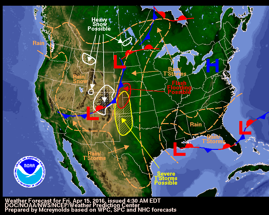
Duo storm systems over the Midwest and Rockies is likely to produce heavy rainfall capable of flooding, severe thunderstorms, and even snow.

The Weather Channel reports that the High Plains will see severe thunderstorms and even some flooding as the 4-5 day period of rain falls over the area. Some parts of the plains may even set all-time monthly records for April.

Many areas in the Plains from South Dakota to Texas could see at least 3 inches of rainfall through Tuesday evening. Parts of Kansas, Oklahoma, Nebraska, and Texas could see around 5-8 inches of rain over the next few days.

Additionally, this storm could produce severe thunderstorms with large hail, damaging winds, and possibly tornadoes.

And if that weren’t enough, the High Plains may also see snow as Winter Storm Vexo hits the Rockies this weekend.

The National Weather Service has issued winter storm warnings for parts of Utah, Colorado, and Wyoming. So far, The Weather Channel has reported that Nebraska and South Dakota will be the only states in the High Plains to possibly see snow.

Winter Storm Vexo will also bring strong winds that could reach gusting speeds of 30-50 mph and may cause power outages throughout the Rockies and High Plains.

Death Toll Rises as Floodwaters Continue to Plague Missouri, Other States

Large portions of the central United States remained under flood warnings on Thursday morning as high waters continued to wreak havoc on dozens of riverside communities.

The National Weather Service issued the warnings for significant swaths of Arkansas, Kansas, Oklahoma and Missouri, where floodwaters reached historic levels following a powerful winter storm, but also issued isolated flood warnings throughout the southeast. The service also issued flash flooding watches in large portions of Florida, Alabama, Georgia and South Carolina.

While floodwaters began to recede in many locations, particularly around hard-hit greater St. Louis, they remained at critically high levels. The National Weather Service warned that towns and cities further south along the Mississippi River could experience “significant river flooding” into mid-January as the massive amounts of water flowed downstream, according to its website.

The National Oceanic and Atmospheric Administration (NOAA) reported that 365 river gauges remained at flood stages on Thursday, 44 of which were at “major flooding” levels. The river gauges don’t always consider lakes, creeks or streams, many of which also breached their banks.

Missouri Governor Jay Nixon, who declared a state of emergency and mobilized the National Guard in the wake of the flooding, said the floods are responsible for killing 14 people in the state, according to a news release from his office. The Missouri Department of Transportation said at least 200 roads were submerged statewide early Thursday, according to a news release.

A busy 21-mile stretch of Interstate 44 remained closed near St.Louis, and the statement from Nixon’s office indicated it was the first time floodwaters shut down the road since 1982.

The Meramec River in Valley Park, Missouri, near St. Louis, crested at a record level of 44.11 feet early Thursday, according to the NOAA, which was more than four feet above a 33-year-old record and only the second time the river reached 38 feet in the past century. The river receded slightly to 43.57 feet later Thursday, the NOAA said, but that was still 27 feet above flood stage.

The community ordered those in low-lying areas to evacuate as the waters surged toward historic heights, according to a posting on its Facebook page. The city is protected by a levee, the posting indicates, but there was still “significant flooding” in several portions of the city.

The Meramec River flooding also damaged “hundreds of homes and businesses” in Pacific, Missouri, according to the governor’s office. The city, located upstream from Valley Park, crested just shy of its all-time record, the NOAA said, but that was still 18 feet above flood stage.

As the waters departed Valley Park and Pacific, they arrived further downstream.

NOAA data indicates the Meramec River in Arnold climbed to an all-time high of 47.22 feet on Thursday morning, nearly two feet above the record and roughly 23 feet above flood stage. The city recommended people evacuate because of the danger to residences, according to its website.

The Meramec flows into the Mississippi River, and communities downstream were expected to see waters rise further. In Chester, Illinois, the NOAA said waters were already at 44.26 feet on Thursday, 17 feet above flood stage and its second-highest level ever, and forecasts called for another 3-foot rise this week. Several roads in the city were already closed, its website indicates.

“This historic flooding event will continue to cause significant hazards and disruptions – from Missourians being forced from their homes, to businesses temporarily closing, to traffic congestion and impacts on interstate commerce due to the closure of a major trucking corridor,” Nixon said in a statement. “I thank the many Missourians who are assisting their neighbors by providing rooms in their homes, helping with sandbagging efforts and countless other acts of kindness.”

Missouri wasn’t the only state affected by the extreme weather.

The storm dumped snow, ice and rain throughout Oklahoma, prompting Governor Mary Fallin to extend a state of emergency. The state Department of Emergency Management reported Wednesday evening that five people lost their lives and another 104 were injured in the storm.

Earlier this week, Illinois Governor Bruce Rauner said “significant issues related to flooding” had occurred in seven counties and he issued a disaster proclamation for those areas, according to a news release from his office.

Canada to accept 25,000 Syrian refugees by February

Canada’s newly elected government will resettle 25,000 refugees from Syria in the next three months, according to multiple published reports, with 10,000 able to arrive by the end of 2015.

That’s a change to the Liberal government’s original plan to bring all 25,000 in by year’s end.

During his election campaign, Prime Minister Justin Trudeau had promised to bring in all of the refugees before Dec. 31, 2015. But the country’s immigration officials said host communities needed more time to prepare to receive the refugees, according to a CBC report on the subject. They will be spread out through 36 different cities throughout Canada, 13 of them in Quebec.

Resettling 25,000 refugees between the Oct. 19 elections and the Dec. 31 deadline would have required the country to accept more than 340 refugees every day. Some politicians had been asking to slow down the timeline to allow more time for security vetting, the CBC reported.

Trudeau told the CBC that the adjustment to the proposal was “not about security.” While he conceded that recent terrorist attacks in Paris has affected the public perception of refugees, the prime minister insisted that the ISIS-affiliated attacks did not influence the revision to the plan.

“We want these families arriving to be welcomed, not feared,” Trudeau told the CBC.

The country’s public safety minister, Ralph Goodale, told the CBC that security screenings will completed on the refugees before they board a plane to Canada. If the checks uncover any doubts about applications, interviews or data, he said, the application will be put on hold.

The refugees will be a mix of privately sponsored and government-assisted individuals. They must register with the United Nations or government of Turkey, according to a BBC report.

Canada will accept the most vulnerable individuals first. These include entire families, at-risk women, and members of the LGBT community. Single men and those not accompanied by their families won’t be initially included in the relocation plan, according to multiple media reports.

Some are wondering if excluding straight, single men from the plan is really necessary.

Benoit Gomis, an international security analyst, wrote in an email to Newsweek that “the multi-layer vetting process should be sufficient enough to alleviate security concerns,” and noted that there wasn’t any evidence that suggested refugees were more dangerous than non-refugees.

“The Migration Policy Institute recently pointed out that out of the 784,000 refugees resettled in the U.S. since 9/11, only three were arrested for terrorism offenses (and they were not plotting attacks in the U.S.),” he wrote. “This type of knee-jerk reaction is common after terrorist attacks.”