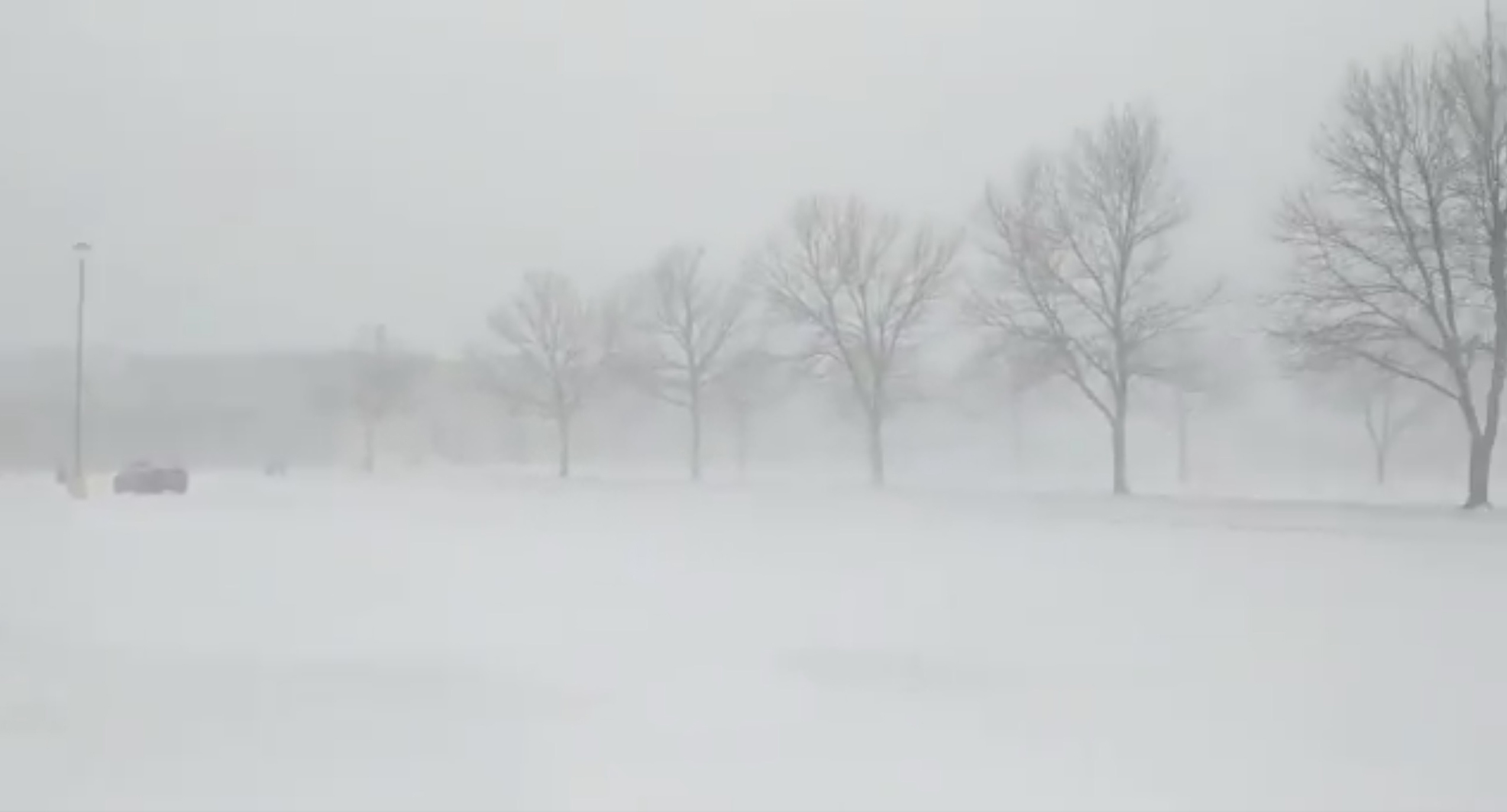
Dorian to hit Bahamas as ‘devastating’ hurricane, then menace Georgia and Carolinas

Hurricane Dorian is seen from the National Oceanic and Atmospheric Administration NOAA's GOES-East Satellite, over the Atlantic Ocean, August 31, 2019 in this handout image obtained from social media. NOAA/Handout via REUTERS

By Zachary Fagenson

JACKSONVILLE, Fla. (Reuters) – Hurricane Dorian punched northwest on Saturday to threaten Georgia and the Carolinas, possibly sparing Florida a direct hit, as the Bahamas braced for catastrophic waves and wind from the muscular category 4 storm.

Florida towns told residents to remain vigilant despite forecasts they might dodge a Dorian landfall, as a tropical storm watch was issued for the state’s south Atlantic coast.

Communities in northeast Florida, Georgia and South Carolina raised alert levels, with residents filling sandbags as authorities tested infrastructure and hurricane drills. South Carolina on Saturday joined Georgia, North Carolina and Florida in declaring a state of emergency.

Bahamas Prime Minister Hubert Minnis begged residents of Abaco and Grand Bahamas to head for the main island to escape the “devastating, dangerous” storm.

Hurricane Dorian is seen from the National Oceanic and Atmospheric Administration NOAA-42 WP-3D Orion aircraft during a reconnaissance mission over the Atlantic Ocean, August 30, 2019 in this handout image obtained from social media. Picture taken August 30, 2019. LCDR Robert Mitchell/NOAA/Handout via REUTERS

“I want you to remember: homes, houses, structures can be replaced. Lives cannot be replaced,” Minnis told a news conference, adding that 73,000 people and 21,000 homes were at risk to storm surges of up to 15 feet (4.6 meters).

At 5 p.m. ET (2100 GMT)The National Hurricane Center (NHC) said Dorian was packing maximum sustained winds of 150 mph (240 kph) and would hit the Bahamas on Sunday with more than two feet of rainfall in places, threatening deadly flash floods.

Dorian could then veer northwest and possibly remain at sea as it moved up the U.S. eastern seaboard late on Monday through Tuesday, the NHC said.

A tropical storm watch was issued for a more than 120-mile stretch (193 km) of Florida coast from Deerfield Beach to around Palm Bay, meaning sustained winds of up to 73 mph (117 kmh)were possible within 48 hours.

North Carolina authorities warned residents Dorian was heading their way, while counterparts in Florida told towns to remain alert.

“While obviously for us it’s a better forecast, we can’t assume that there’s not going to be hazardous weather,” said Miami Beach Mayor Dan Gelber.

BAHAMAS ON SUNDAY

Central Florida towns urged residents to remain alert after past hurricanes like 1992’s Andrew slammed the Bahamas and then barreled straight into the peninsula’s southeast coast.

“Don’t start taking down your shutters, don’t start disassembling your emergency plan,” said Eric Flowers, a spokesman for the sheriff’s office in Indian River County.

On Tybee Island, a Georgia coastal barrier island, authorities put out sand for sandbags to protect against possible flooding in the marshy area.

“Our biggest concern is storm surge because the tides are really high right now,” said the manager of a local restaurant, who asked not be named as he was not authorized to speak to media.

Further north, Dorchester County in South Carolina raised its alert level to make sure infrastructure and public safety crews were ready for the hurricane in the area near the historic city of Charleston.

North Carolina Emergency Management (NCEMA) said the storm was forecast to keep moving in the state’s direction for the next 48 hours.

“Now is the time to prepare and assemble disaster supplies,” said Katie Webster, an NCEMA meteorologist, urging people to prepare a week’s supply of food and water.

(Reporting by Zachary Fagenson in Jacksonville, Andrew Hay in New Mexico; Additional reporting by Daniel Wallis in New York; Editing by Rosalba O’Brien and Franklin Paul)

NHC sees 80% chance of cyclone off North Carolina

Location map, National Hurricane Center

(Reuters) – A low pressure area located about 280 miles (451 km) south-southeast of Cape Hatteras, North Carolina has an 80% chance of becoming a tropical cyclone over the next 48 hours, the U.S. National Hurricane Center said on Monday.

The system is forecast to move slowly north-eastward, well offshore of the southeastern United States, the Miami-based weather forecaster added.

(Reporting by K. Sathya Narayanan in Bengaluru; Editing by Jacqueline Wong)

Back-to-back hurricanes churn towards Hawaii

Hurricanes Erick and Flossie 7-31-19

By Rich McKay

(Reuters) – Back-to-back hurricanes churned in the eastern Pacific on Wednesday towards Hawaii, with one set to lose punch when it reaches the U.S. archipelago state even as its mate gains might.

The closest to Hawaii was Hurricane Erick, which swelled from a tropical storm on Monday to a Category 4 hurricane on Tuesday on the Saffir-Simpson wind scale.

But it has since weakened to Category 3 with sustained winds of 125 mph (205 kph), the National Hurricane Center (NHC) in Miami said on Wednesday.

It was about 695 miles (1,115 km) from Hawaii’s Big Island.

Erick is expected to continue to lose its might, dwindling back into a tropical storm by the time it makes its closest approach to Hawaii.

It is forecast to skirt south of the Big Island on Friday morning. Meteorologists see a higher chance of gale-force winds from the storm on the Big Island later this week.

Meanwhile, farther east in the Pacific, Hurricane Flossie, a Category 1 with sustained winds of 80 mph (130 kph), is expected to gradually gain power and speed over the next few days, the NHC said early on Wednesday.

It was about 1,150 miles (1,850 km) southwest of the Mexican state of Baja California, an advisory said, and was slowly headed west, getting stronger over the next few days.

The latest forecast shows it approaching the island by 8 p.m. Sunday, a forecaster at the NHC said.

(Reporting by Rich McKay in Atlanta; Editing by Andrew Cawthorne)

U.S. oil firms cut nearly a third of Gulf of Mexico output ahead of storm

FILE PHOTO: A massive drilling derrick is pictured on BP's Thunder Horse Oil Platform in the Gulf of Mexico, 150 miles from the Louisiana coast, May 11, 2017. REUTERS/Jessica Resnick-Ault/File Photo

By Collin Eaton and Erwin Seba

HOUSTON (Reuters) – U.S. oil producers on Wednesday cut nearly a third of offshore Gulf of Mexico crude output as what could be one of the first major storms of the Atlantic hurricane season threatened production.

Fifteen oil production platforms and four rigs were evacuated in the north central area of the Gulf of Mexico, according to the U.S. Bureau of Safety and Environmental Enforcement (BSEE), ahead of a storm expected to become a hurricane by Friday.

Exxon Mobil Corp, Chevron Corp, Anadarko Petroleum Corp and others withdrew staff, and some cut production from deepwater platforms as a safety precaution.

The withdrawals helped push U.S. oil futures up 4% to more than $60 a barrel, and lifted gasoline prices. The U.S. Gulf of Mexico produces 17% of U.S. crude oil and 5% of natural gas. Gasoline futures climbed more than 3.5% in New York trading.

A tropical depression is expected to form in the Gulf by Thursday, with the potential to strengthen to a hurricane by the weekend, according to the National Hurricane Center. The system could produce a storm surge and heavy rainfall from Louisiana to the upper Texas coast.

Louisiana Governor John Bel Edwards on Wednesday declared a state of emergency, warning that the storm system could bring up to 15 inches of rain and hurricane-force winds to parts of Louisiana. A state of emergency allows for the activation of the state’s National Guard and the setting of curfews.

The Atlantic hurricane season runs from June through November.

BSEE said more than 600,000 barrels per day of Gulf oil production and 17% of the region’s natural gas production were shut by producers.

Exxon has evacuated nonessential staff from three platforms in the Gulf, but anticipates little effect on its production, spokeswoman Julie King said.

Anadarko, the third largest U.S. Gulf producer by volume, said it is stopping oil and gas production and removing workers from its four central Gulf facilities: the Constitution, Heidelberg, Holstein and Marco Polo platforms. It said it is also evacuating nonessential staff from eastern Gulf platforms.

Royal Dutch Shell Plc expanded an earlier offshore evacuation to seven platforms and shut more production, the company said on Wednesday.

Operations at the Louisiana Offshore Oil Port, the only U.S. port where the largest crude tankers can load and unload, were normal on Wednesday morning, a spokeswoman said.

Oil refiners Motiva Enterprises and Marathon Petroleum Corp said they were monitoring the developing storm and prepared to implement hurricane plans.

Motiva’s Port Arthur, Texas, refinery was one of four refineries in east Texas inundated by more than 5 feet (1.52 m) of rain in a single day during 2017’s Hurricane Harvey.

Chevron, Phillips 66, Exxon and Royal Dutch Shell were preparing for heavy rain and wind at refineries along the Gulf Coast, company representatives said. Exxon reported operations at its Gulf Coast refineries were normal on Wednesday morning.

Chevron has shut production at five Gulf platforms – Big Foot, Blind Faith, Genesis, Petronius and Tahiti – and has begun to evacuate all workers at those offshore facilities, spokeswoman Veronica Flores-Paniagua said.

BP Plc, the second-largest oil producer in the Gulf by volume, is shutting all production at its four Gulf platforms – Thunder Horse, Atlantis, Mad Dog and Na Kika – which produce more than 300,000 barrels of oil equivalent per day.

BHP Group Ltd was also removing staff from its two offshore energy platforms, according to a company statement.

Two independent offshore producers, Fieldwood Energy LLC and LLOG Exploration Company LLC, declined to comment.

(Reporting by Collin Eaton and Erwin Seba in Houston; Editing by Gary McWilliams, Matthew Lewis and Leslie Adler)

After Cyclone Idai, thousands still cut off, many more in need: aid agencies

FILE PHOTO: Women wait to receive aid at a camp for the people displaced in the aftermath of Cyclone Idai in John Segredo near Beira, Mozambique March 31, 2019. REUTERS/Zohra Bensemra

JOHANNESBURG (Reuters) – One month after Cyclone Idai tore through southern Africa bringing devastating floods, aid agencies say the situation remains critical with some communities in worst-hit Mozambique only just being reached with aid.

The storm made landfall in Mozambique on March 14, flattening the port city of Beira before moving inland to batter Malawi and Zimbabwe.

It heaped rain on the region’s highlands that then flowed back into Mozambique, leaving an area the size of Luxembourg under water. More than 1,000 people died across the three countries, and the World Bank has estimated more than $2 billion will be needed for them to recover.

FILE PHOTO: Survivors of cyclone Idai arrive at Coppa business centre to receive aid in Chipinge, Zimbabwe, March 26, 2019. REUTERS/Philimon Bulawayo/File Photo

Over the weekend, aid agencies said thousands of people were still completely cut off and warned of the potential for a catastrophic hunger crisis to take hold, especially as aid appeals went largely underfunded.

Dorothy Sang, Oxfam’s humanitarian advocacy manager, said an aid drop was being planned for an isolated area where just last week 2,000 people were found for the first time since the storm. They had been surviving on coconuts, dates and small fish they could catch.

Oxfam estimates there are 4,000 people still cut off. Sang added that while often these weren’t the worst-hit by the disaster, they were already living in chronic poverty and now face huge challenges to survive.

“They risk becoming utterly forgotten,” she said.

On Sunday, Care International said the destruction of crops would compound existing food security problems across the region, and called on donors to find additional funds for the response.

Mozambique’s $337 million humanitarian response plan, largely made up of an appeal for $281 million after the cyclone hit, remained only 23 percent funded on Monday.

The United Nations has also requested $294 million for Zimbabwe, an appeal currently 11 percent funded. The government has separately asked for $613 million to help with the humanitarian crisis.

Meanwhile, U.N. children’s agency Unicef warned at least 1.6 million children need some kind of urgent assistance, from healthcare to education, across all three countries. Save the Children also said many are traumatized after witnessing the death and destruction wrought by the storm.

Machiel Pouw, Save the Children’s response team leader, said children and their families needed long-term help to recover.

“After a disaster of this scale, the world must not look away.”

(Reporting by Emma Rumney; Editing by Hugh Lawson)

Deadly storms leave thousands without power in eastern U.S

A view of clouds, part of a weather system seen from near Franklin, Texas, U.S., in this still image from social media video dated April 13, 2019. TWITTER @DOC_SANGER/via REUTERS

(Reuters) – Tornadoes, wind gusts of up to 70 mph and pounding hail remained threats early on Monday from eastern New York and into New England, as the remnants of a deadly storm push out to sea, the National Weather Service said.

More than 79,000 homes and businesses were without power in Virginia, according to the tracking site PowerOutage.US, with 89,000 more outages reported across Pennsylvania, North Carolina, Michigan, Maryland and New York.

The affected areas will get heavy rains, winds with gusts of up to 70 mph (110 kph) and the possibility of hail, NWS Weather Prediction Center in Maryland said.

“This is an ongoing threat,” said Brian Hurley, from the center.

“There are short spin-ups, pockets of heavy rain and damaging winds that can still hit before this pushes off shore.”

The weekend’s storm brought tornadoes that killed at least five people, including three children, in the U.S. South, officials said.

The massive storm system sped from Texas eastward with dozens of twisters reported as touching down across the South from Texas through Georgia into Pennsylvania.

Nearly 2,300 U.S. flights were canceled by Sunday evening, more then 90 percent of them at airports in Chicago; Houston, Texas; Charlotte, North Carolina; Pittsburgh; Columbus, Ohio and a dozen major airports on the Eastern Seaboard, according to FlightAware.com.

But no major flight delays were reported on the east coast before 6 a.m. Monday.

The storm’s cold front brought snow to Chicago on Sunday, with 1 to 3 inches (2.5-7.6 cm) reported in central Illinois.

Two children, siblings aged three and eight, were killed on Saturday when a tree fell on the car in which they were sitting in Pollok, Texas, said a spokeswoman for the Angelina County Sheriff’s Department.

A third child, Sebastian Omar Martinez, 13, drowned late on Saturday when he fell into a drainage ditch filled with flash floodwaters near Monroe, Louisiana, said Deputy Glenn Springfield of the Ouachita Parish Sheriff’s Office.

In another storm death nearby, an unidentified victim’s body was trapped in a vehicle submerged in floodwaters in Calhoun, Louisiana, Springfield said.

In Mississippi, Governor Phil Bryant said one person was killed and 11 injured over the weekend as tornadoes ripped through 17 counties and left 26,000 homes and businesses without electricity.

In addition, three people were killed when a private jet crashed in Mississippi on Saturday, although Bryant said it was unclear whether it was caused by the weather.

Soaking rains could snarl the Monday morning commute on the East Coast before the storm moves off to sea.

“The biggest impact rush hour-wise probably will be Boston, around 7 to 8 o’clock in the morning, and around New York City around 5 or 6 o’clock, before sunrise,” NWS meteorologist Bob Oravec said.

(Reporting by Rich McKay in Atlanta, and Barbara Goldberg and Peter Szekely in New York; Editing by Hugh Lawson and Alison Williams)

Blizzard clobbers Plains and Midwest after blanketing the U.S. Rockies

A bicyclist exits the Midtown Greenway bicycle and pedestrian trail during the spring snowstorm in Minneapolis, Minnesota, U.S., April 11, 2019. REUTERS/Annabelle Marcovici

By Keith Coffman

DENVER (Reuters) – A powerful blizzard slammed the U.S. Plains and Midwest on Thursday with heavy snow and fierce winds that caused power outages and closed highways while raising fears of more flooding in the Midwest after a deluge last month.

The system was dumping more than a foot (0.3 m) of heavy snow and winds were gusting up to 65 miles (105 km) per hour from northeast Colorado north to northern Wisconsin, the National Weather Service said in multiple advisories.

Whiteout conditions on roadways were making “travel extremely dangerous,” according to the weather service. Blizzard and winter storm warnings would remain in effect across the region through Friday morning, it said.

“Conditions will continue to deteriorate the rest of the afternoon and overnight,” said Dan Effertz, a NWS meteorologist in Minnesota. “This is a very potent storm.”

Local media reported dozens of crashes and cars in ditches as several major highways and roads were shut down in parts of the U.S. Plains and Midwest. Some counties issued “no travel” advisories, warning drivers to stay off the roads.

“Blizzard, day two. Not even the pack of sled dogs can handle these roads,” said Minnesota crime novelist Anthony Neil Smith on Twitter.

More than 30,000 homes and businesses were without power in Minnesota, 14,200 in Iowa and 22,700 in Michigan by midday on Thursday, according to PowerOutages.us, a website that tracks power outages.

The storm beginning on Wednesday has already dumped more than 2 feet of snow on parts of South Dakota and more than about a foot of snow in communities in Wyoming, Montana and Colorado.

The storm caused officials to close schools and governmental offices in dozens of communities.

In addition to snow, the storm was bombarding the region with rain, sleet, freezing rain and thunderstorms.

“You can probably even throw in the kitchen sink at this point,” the weather service said in a Tweet.

The blizzard, dubbed a “bomb cyclone” because of its rapidly intensifying funnel shape, is the second one to hit the region over the past month.

In March, another “bomb cyclone” triggered heavy rain over the region and combined with melting snow to cause flooding along the Missouri River and its tributaries. Damages and losses to property, cattle and crops in Nebraska and Iowa alone were estimated at more than $3 billion.

Officials in Nebraska on Thursday were cautiously watching the forecast and river levels to the north, said Jodie Fawl, a spokeswoman for the Nebraska Emergency Management Agency.

“We are waiting to see what happens when the snow melts,” she said, noting that warm temperatures since then have thawed the ground and could result in less flooding. “We are just going to have to wait and see.”

Despite the severe weather, crew members at Denver International Airport worked through the night to remove snow from runways, and only about 180 flights were canceled on Thursday morning, down from more than 700 a day earlier, according to FlightAware.come, a flight tracking service, and airport officials.

(Additional writing and reporting by Rich McKay in Atlanta and Brendan O’Brien in Milwaukee; additional reporting by Andrew Hay in Taos, New Mexico, Gina Cherelus in New York and Alex Dobuzinskis in Los Angeles; editing by Bernadette Baum and Phil Berlowitz)

Blizzard moves towards Plains and Midwest after waning in the U.S. Rockies

A general view of the blizzard in Greeley, Colorado, U.S. March 13, 2019 in this picture obtained from social media. Mandatory credit TWITTER @PHOTOWILLG/via REUTERS

By Keith Coffman

DENVER (Reuters) – A powerful storm bringing heavy snowfall and strong winds was churning across the U.S. Plains and Midwest on Thursday, a day after a blizzard in the Rocky Mountains grounded flights, caused power outages and raised fears of further Midwest flooding after a deluge last month.

Warm spring temperatures on Tuesday, upwards of 80 degrees Fahrenheit in Denver, gave way to frigid 20s, heavy snow, gale-force winds and life-threatening conditions through Thursday, the National Weather Service said.

David Roth, a meteorologist with the weather service’s Weather Prediction Center, said that while the Rockies were expected to receive constant precipitation until Saturday, the center of low pressure of the blizzard was spinning into the U.S. Plains and Midwest.

Roth said the storm system will turn northeast into Minnesota late on Thursday and then slowly move into Lake Superior by Friday night.

Heavy snow with blizzard conditions was expected through Thursday night in southeastern South Dakota and southwestern Minnesota, the weather service said.

Despite the severe weather, crew members at Denver International Airport worked through the night to remove snow from runways, and only about 180 flights were canceled on Thursday morning, down from more than 700 a day earlier, according to FlightAware.come, a flight tracking service, and airport officials.

“Some cancellations and delays are expected today, so be sure to check your flight status with your airline!” airport officials wrote on Twitter on Thursday.

Residents throughout the north-central United States could expect downed trees, widespread power outages, road closures and treacherous driving through Friday, the NWS said.

More than 10,000 homes and businesses were without power in South Dakota and about another 10,000 in Minnesota early Thursday.

Officials in Colorado ordered state government offices in 54 counties to be closed on Thursday, according to a statement posted on Facebook. Government offices in Denver were closed on Wednesday afternoon due to weather conditions, according to a statement on the state’s website.

Brian Hurley, another meteorologist with the weather service, had previously described the powerful blizzard as a “bomb cyclone,” the second one to hit the area in two months.

“This is like a slow-moving snowstorm inside a hurricane,” Hurley said, adding that wind gusts were upwards of 100 mph on Wednesday in eastern Colorado.

In March, another “bomb cyclone,” which involves a rapidly intensifying cyclone, triggered heavy rain over the region and combined with melting snow to cause flooding along the Missouri River and its tributaries. Damages and losses to property, cattle and crops in Nebraska and Iowa alone were estimated at more than $3 billion .

This week’s weather system is expected to weaken and move to the Great Lakes area on Friday, bringing rain and snow to that region, the Weather Service said.

“All that snow is going to melt sooner rather than later, and it’ll all flow into the Missouri River basin,” Hurley said.

(Additional writing and reporting by Rich McKay in Atlanta; additional reporting by Andrew Hay in Taos, New Mexico; Gina Cherelus in New York and Alex Dobuzinskis in Los Angeles; editing by Larry King and Bernadette Baum)

Powerful, ‘abnormal’ rains lash Rio de Janeiro, at least six dead

Firefighters work at the site of a mudslide after a heavy rain at the Babilonia slum in Rio de Janeiro, Brazil, April 9, 2019. REUTERS/Pilar Olivares

By Pedro Fonseca and Rodrigo Viga Gaier

RIO DE JANEIRO (Reuters) – Torrential rains doused Rio de Janeiro on Tuesday, killing at least six people and sowing chaos in Brazil’s second largest city, which declared a state of emergency after a storm that the mayor described as “absolutely abnormal.”

A bus is seen underneath trees uprooted by heavy rains in the Leblon neighbourhood in Rio de Janeiro, Brazil April 9, 2019. REUTERS/Sergio Moraes

A bus is seen underneath trees uprooted by heavy rains in the Leblon neighbourhood in Rio de Janeiro, Brazil April 9, 2019. REUTERS/Sergio Moraes

A woman and her 7-year-old granddaughter were buried in a mudslide as they rode in a taxi, and the driver’s body was also found inside the vehicle, police detective Valeria Aragao told O Globo newspaper. Two adult sisters died when their home in a slum was buried in a mudslide, while a man drowned in another part of the city, the mayor’s office said in a statement.

The rains began around Monday evening and had not let up by midday Tuesday, with a heavy downpour forecast through the end of the day. More than 34 cm (13 inches) of rain fell on parts of the city in the last 24 hours, according to the mayor’s office.

Videos on local news showed normally calm residential streets turned into raging torrents that dragged people and cars. A coastal bike path meant to be a legacy of the 2016 Olympics that had been weakened by previous storms suffered more damage, with chunks of the path falling into the sea.

“These rains are absolutely abnormal for this time of year; none of us expected so much rain at this time,” Mayor Marcelo Crivella told an early morning news conference.

The mayor’s office declared a state of emergency on Monday night. Major roads were closed, and the mayor’s office said 785 places were without power.

Emergency services acted to rescue people trapped in cars and on the streets. TV images on Tuesday showed divers examining a car submerged in a flooded underpass.

A truck is seen stuck on a flooded street during heavy rains in the Jardim Botanico neighborhood in Rio de Janeiro, Brazil April 9, 2019. REUTERS/Sergio Moraes

A truck is seen stuck on a flooded street during heavy rains in the Jardim Botanico neighborhood in Rio de Janeiro, Brazil April 9, 2019. REUTERS/Sergio Moraes

Rio’s streets were quieter than usual on Tuesday, as nearly all schools shut and people worked from home to avoid the risk of being trapped at work.

It was the second major storm in two months to batter Rio. A violent tempest that hit the city in February killed at least seven people.

(Reporting by Pedro Fonseca and Rodrigo Viga Gaier in Rio de Janeiro; Additional reporting by Gabriel Stargardter in Rio and Brad Brooks in Sao Paulo; Editing by Jonathan Oatis and Leslie Adler)

Death toll in Mozambique cyclone, floods could surpass 1,000: president

Flooding caused by Cyclone Idai is seen in Chipinge, Zimbabwe, March 16, 2019 in this still image taken from social media video obtained March 17, 2019. Tony Saywood via REUTERS

MAPUTO/HARARE (Reuters) – The number of people killed in a powerful storm and preceding floods in Mozambique could exceed 1,000, the president said on Monday, putting the potential death toll greatly more than current figures.

Only 84 deaths have been confirmed so far in Mozambique as a result of Cyclone Idai, which has also left a trail of death and destruction across Zimbabwe and Malawi, with vast areas of land flooded, roads destroyed and communication wiped out.

Speaking on Radio Mocambique, President Filipe Nyusi said he had flown over the affected region, where two rivers had overflowed. Villages had disappeared, he said, and bodies were floating in the water.

“Everything indicates that we can register more than one thousand deaths,” he said.

The cyclone has also killed 89 people in Zimbabwe, an official said on Monday, while the death toll in Malawi from heavy rains and flooding stood at 56 as of last week. No new numbers had been released following the cyclone’s arrival in the country.

Caroline Haga, a senior International Federation of the Red Cross official who is in Beira, said the situation could be far worse in the surrounding areas, which remained completely cut off by road and where houses were not as sturdy.

Nyusi flew over areas that were otherwise accessible, and some of which had been hit by flooding before Cyclone Idai.

RESCUE EFFORT

In Beira, Mozambique’s fourth-largest city and home to 500,000 people, a large dam had burst, further complicating rescue efforts.

Large swathes of land were completely submerged, and in some streets people waded through knee-high water around piles of mangled metal and other debris.

In the early hours of Monday morning, rescuers launched dinghies onto chest-high waters, navigating through reeds and trees – where some people perched on branches to escape the water – to rescue those trapped by the flooding.

Meanwhile, rescuers were struggling to reach people in Zimbabwe’s Chimanimani district, cut off from the rest of the country by torrential rains and winds of up to 170 km per hour that swept away roads, homes and bridges and knocked out power and communication lines.

Zimbabwean information ministry official Nick Mangwana told Reuters the number of confirmed deaths throughout the country was now 89. The body count is expected to rise.

Many people had been sleeping in the mountains since Friday, after their homes were flattened by rock falls and mudslides or washed away by torrential rains.

The Harare government has declared a state of disaster in areas affected by the storm. Zimbabwe, a country of 15 million people, was already suffering a severe drought that has wilted crops.

SOUTHEASTERN AFRICA GATEWAY

Beira, which sits at the mouth of the Pungwe River, is also home to Mozambique’s second-largest port, serving as gateway for imports to landlocked countries in southeast Africa.

The director of a company that jointly manages the port, Cornelder, based in the Netherlands, said the port had been closed since last Wednesday but would hopefully resume operations on Tuesday.

Two cranes would be working and the company had two large generators and enough fuel for now, though damage to access routes and roads further inland was more likely to cause a problem, said the director, who asked not to be named.

The fuel pipeline running from Beira to Zimbabwe was believed to be intact, the person said, though communication was still very patchy and therefore the situation at the port remained uncertain.

In February 2000, Cyclone Eline hit Mozambique when it was already devastated by its worst floods in three decades. It killed 350 people and made 650,000 homeless across southern Africa, also hitting Zimbabwe.

(Reporting by MacDonald Dzirutwe in Zimbabwe and Manuel Mucari in Mozambique; Additional reporting by Emma Rumney in Johannesburg; Editing by Angus MacSwan)